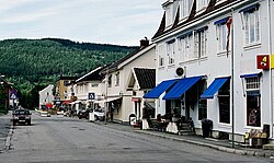
Jevnaker
Jevnaker Municipality
Jevnaker kommune | |
|---|---|
 | |
|
| |
 Oppland within Norway | |
 Jevnaker within Oppland | |
| Country | Norway |
| County | Oppland |
| District | Hadeland |
| Administrative centre | Jevnaker |
| Government | |
| • Mayor (2003) | Hilde Brørby Fivelsdal (Ap) |
| Area | |
• Total | 224 km2 (86 sq mi) |
| • Land | 195 km2 (75 sq mi) |
| • Rank | #317 in Norway |
| Population (2006) | |
• Total | 6,312 |
| • Rank | #159 in Norway |
| • Density | 33/km2 (90/sq mi) |
| • Change (10 years) | |
| Demonym | Jevnakering[1] |
| Official language | |
| • Norwegian form | Bokmål |
| Time zone | UTC+01:00 (CET) |
| • Summer (DST) | UTC+02:00 (CEST) |
| ISO 3166 code | NO-0532[3] |
| Website | Official website |
Jevnaker is a municipality in Oppland county, Norway. The administrative centre of the municipality is the village of Jevnaker with a population of 4,302.
The parish of Jævnaker was established as a municipality on 1 January 1838 (see formannskapsdistrikt). The area of Lunner was separated from the municipality of Jevnaker on 1 January 1898 to form a municipality of its own.
The municipality is (together with Gran and Lunner) a part of the Hadeland traditional region. The Hadeland region has a population of about 30,000. The region spreads over a large area including several villages and towns.
General information
Name
The municipality (originally the parish) is named after the old Jevnaker farm (Old Norse: Jafnakr), since the first church was built here. The first element is jafn which means "even" or "flat" and the last element is akr which means "field" or "acre". Prior to 1889, the name was written "Jævnaker". [4]
Coat-of-arms
The coat-of-arms is from modern times. They were granted on 24 June 1983. The arms show three silver-colored glasses, since glassblowing has been a long tradition and industry in the municipality (see Hadeland Glassverk). The red colour of the background was also chosen as the colour of the glass when hot.[5][6]
(See also coat-of-arms of Gildeskål)
Geography

Jevnaker is situated at the southern end of the Randsfjorden. The municipality is bordered to the north by the municipality of Gran, to the east by Lunner, and to the southwest by Ringerike (in Buskerud county).
Jevnaker municipality has an area of 224 square kilometres (86 sq mi), measuring 25.5 kilometres (15.8 mi) on a north-south axis and 21 kilometres (13.0 mi) on an east-west axis. The municipality lies in the extreme south of Oppland county.
The highest point is Svarttjernshøgda with a height of 717 metres (2,352 ft).
Economy
Jevnaker is home to Hadeland Glassverk, an old glassblowing factory with over 600,000 visitors each year, ranking it as the third most popular tourist destination in Norway.
The Kistefos Træsliberi, an industrial museum with a very impressive Art collection, is also located in Jevnaker

Jevnaker is the home of Artists Geir Kleppan and Lucas Stephens
References
- ^ "Navn på steder og personer: Innbyggjarnamn" (in Norwegian). Språkrådet.
- ^ "Forskrift om målvedtak i kommunar og fylkeskommunar" (in Norwegian). Lovdata.no.
- ^ Bolstad, Erik; Thorsnæs, Geir, eds. (2023-01-26). "Kommunenummer". Store norske leksikon (in Norwegian). Kunnskapsforlaget.
- ^ Rygh, Oluf (1900). Norske gaardnavne: Kristians amt (Anden halvdel) (in Norwegian) (4 ed.). Kristiania, Norge: W. C. Fabritius & sønners bogtrikkeri. p. 118.
- ^ Norske Kommunevåpen (1990). "Nye kommunevåbener i Norden". Retrieved 2009-01-01.
- ^ "Kortfattet informasjon" (in Norwegian). Jevnaker kommune. Retrieved 2009-01-01.
External links
- Municipal fact sheet from Statistics Norway
 Oppland travel guide from Wikivoyage
- Official website Template:No icon
- Gallery Roenland Template:No icon


