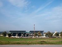
Jijel Ferhat Abbas Airport
Appearance
Jijel Ferhat Abbas Airport | |||||||||||
|---|---|---|---|---|---|---|---|---|---|---|---|
 | |||||||||||
| Summary | |||||||||||
| Airport type | Public | ||||||||||
| Serves | Jijel | ||||||||||
| Location | Emir Abdelkader, Algeria | ||||||||||
| Elevation AMSL | 11 m / 36 ft | ||||||||||
| Coordinates | 36°47′40″N 05°52′25″E / 36.79444°N 5.87361°E | ||||||||||
| Map | |||||||||||
 | |||||||||||
| Runways | |||||||||||
| |||||||||||
Jijel Ferhat Abbas Airport (IATA: GJL, ICAO: DAAV), also known as Ferhat Abbas Airport, is an airport near Jijel, Algeria.
Airlines and destinations
| Airlines | Destinations |
|---|---|
| Air Algérie | Algiers Seasonal: Marseille |
References
- "DAAV @ aerobaticsweb.org". Landings.com.
- OurAirports - Jijel
External links


