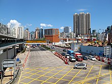
Jordan Road, Hong Kong
You can help expand this article with text translated from the corresponding article in Chinese. (July 2014) Click [show] for important translation instructions.
|
| Jordan Road, Hong Kong | |||||||||||
|---|---|---|---|---|---|---|---|---|---|---|---|
 | |||||||||||
| Chinese | 佐敦道 | ||||||||||
| |||||||||||


Jordan Road is a road in Yau Ma Tei, Kowloon, Hong Kong. It spans from the West Kowloon Highway in West Kowloon, through Ferry Point to Gascoigne Road, and is a major east-west road in southern Kowloon.
History
An English language source states that Jordan Road was named for John Newell Jordan, British minister to China.[1] Some Chinese language sources state that the road, which was constructed in 1887, was renamed from Sixth Street in 1909[2] to commemorate British pathologist G. P. Jordan, who served as Health Officer in Hong Kong for nearly thirty years.[3][4][5][6][7] In 1908, a stone obelisk was erected as a memorial to French sailors of the "Fronde" who had drowned in the 1906 typhoon. Originally located at the corner with Gascoigne Road, the monument has since been relocated to the Colonial Cemetery at Happy Valley.[8] Prior to the opening of the Cross-Harbor Tunnel in 1972, ferries such as the ones departing from Jordan Road were the only way to transport automobiles from Kowloon to Hong Kong. Once a quiet, suburban street, since the 1950s Jordan Road and its surrounding area have become one of the most overcrowded areas in Kowloon.[1]
Ferry Pier
At the end of the road, there was the Jordan Road Ferry Pier in Ferry Point, with ferries carrying passengers and vehicles to Central of Hong Kong Island. Until the completion of the Cross-Harbour Tunnel, it was a major transport hub to and from the Hong Kong Island. There was also an important bus terminus, Jordan Road Ferry Pier Bus Terminus, near the pier. The bus terminus hosted many routes to the New Territories. After the completion of major part of reclamation in West Kowloon, the bus terminus was moved to Jordan (Wui Cheung Road) Bus Terminus in the new reclamation nearby. In 2011-2012, the bus terminus was closed and most routes were rerouted to Jordan (To Wah Road). Some go to Kowloon Railway Station bus terminus, near Kowloon Station of the Mass Transit Railway (MTR) Airport Express. These factors make Jordan Road an important transportation access point.
Station
Jordan Station of the MTR was named after Jordan Road, between the centres of Yau Ma Tei and Tsim Sha Tsui. The station's name is so commonly used that it has gradually replaced the traditional name, Kwun Chung, for the neighbourhood.
See also
References
- ^ a b Jason Wordie. Streets: Exploring Kowloon. Hong Kong University Press. pp. 60–61. ISBN 9789622098138.
{{cite book}}: Cite has empty unknown parameter:|coauthors=(help) - ^ The Hong Kong Government Gazette, March 19, 1909
- ^ 《九龍街道命名考源》梁濤 著,第二十八頁,市政局出版,1993年
- ^ 《香港歷史文化小百科16-趣談九龍街道》 爾東 著,第141-142頁,明報出版社,2004年11月,ISBN 962-8871-46-3
- ^ "道路及鐵路 - 曾改名道路(二)九龍及新界".
- ^ "香港掌故 街道名稱的由來(六之三)".
- ^ "Hong Kong Official Lauds Ellis Island". New York Times. July 12, 1914. Retrieved 2014-08-05.
{{cite news}}: Cite has empty unknown parameter:|coauthors=(help) - ^ Patricia Lim (2011). Forgotten Souls: A Social History of the Hong Kong Cemetery. Hong Kong University Press. p. 448. ISBN 9789622099906. Retrieved 16 August 2014.
{{cite book}}: Cite has empty unknown parameter:|coauthors=(help)
