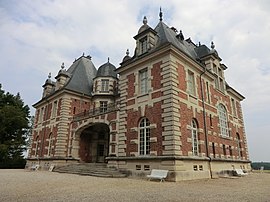
Joyeux, Ain
You can help expand this article with text translated from the corresponding article in French. (December 2008) Click [show] for important translation instructions.
|
Joyeux | |
|---|---|
 Chateau | |
| Country | France |
| Region | Auvergne-Rhône-Alpes |
| Department | Ain |
| Arrondissement | Bourg-en-Bresse |
| Canton | Meximieux |
| Intercommunality | Plaine de l'Ain |
| Government | |
| • Mayor (2008–2014) | Marius Brocard |
Area 1 | 16.58 km2 (6.40 sq mi) |
| Population (2008) | 233 |
| • Density | 14/km2 (36/sq mi) |
| Time zone | UTC+01:00 (CET) |
| • Summer (DST) | UTC+02:00 (CEST) |
| INSEE/Postal code | 01198 /01800 |
| Elevation | 272–298 m (892–978 ft) (avg. 285 m or 935 ft) |
| 1 French Land Register data, which excludes lakes, ponds, glaciers > 1 km2 (0.386 sq mi or 247 acres) and river estuaries. | |
Joyeux is a commune in the Ain department in eastern France.
Geography
Joyeux lies less than 5 km (3.1 mi) from the wildlife park at Villars-les-Dombes and 40 km (25 mi) from Lyon in the natural region of the Dombes, a wide extent of middle and upper Pleistocene moraine left near the margin of the Alpine ice sheets. The commune includes some thirty lakes which together represent some 4 square kilometres of water. The land between them is of gravel, sand and clay.
History
The fief of Joyeux was mentioned in the twelfth century. In the fifteenth century, it was in the possession of the Villars family.
On 13 February 2006, a wild duck was found dead on the fen. It was the first attested case of the presence of the bird flu virus H5N1 in France.
Administration
| Period | Name | Party | Background |
|---|---|---|---|
| 2001 | Marius Brocard | Farmer |
Population
| Year | Pop. | ±% |
|---|---|---|
| 1962 | 135 | — |
| 1968 | 146 | +8.1% |
| 1975 | 142 | −2.7% |
| 1982 | 151 | +6.3% |
| 1990 | 171 | +13.2% |
| 1999 | 206 | +20.5% |
| 2006 | 233 | +13.1% |
Sights
Old farms typical of the region. The nineteenth century Château de Joyeux.

