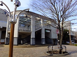
Kita-Yono Station
Kita-Yono Station 北与野駅 | |
|---|---|
 South side of Kita-Yono Station | |
| General information | |
| Location | 2-3-1 Kami-Ochiai, Chūō-ku, Saitama-shi, Saitama-ken (埼玉県さいたま市中央区上落合2丁目3-1) Japan |
| Operated by | |
| Line(s) | ■Saikyō Line |
| Platforms | 1 island platform |
| Connections |
|
| History | |
| Opened | 1985 |
| Passengers | |
| FY2014 | 8,701 daily |
Kita-Yono Station (北与野駅, Kita-Yono-eki) is a railway station on the Saikyō Line in Chūō-ku, Saitama, Saitama Prefecture, Japan, operated by the East Japan Railway Company (JR East).[1]
Lines
Kita-Yono Station is served by the Saikyō Line which runs between Ōsaki in Tokyo and Saitama in Saitama Prefecture. Some trains continue northward to Kawagoe via the Kawagoe Line and southward to Shin-Kiba via the TWR Rinkai Line. Kita-Yono Station is located 21.7 km from Ikebukuro Station.[2] The station identification colour is blue.[2]
Station layout
The station consists of one elevated island platform serving two tracks, with the station building located underneath. The tracks of the Tōhoku Shinkansen also run adjacent to this station, on the west side.[2]
Platforms
| 1 | ■ Saikyō Line | for Musashi-Urawa, Akabane, Shinjuku, and Ōsaki Rinkai Line for Shin-Kiba |
| 2 | ■ Saikyō Line | for Saitama and Kawagoe |
Adjacent stations
| « | Service | » | ||
|---|---|---|---|---|
| Saikyō Line | ||||
| Commuter Rapid: Does not stop at this station | ||||
| Rapid: Does not stop at this station | ||||
| Yonohommachi | Local | Saitama | ||
History
The station opened on 30 September 1985.[2]
Passenger statistics
In fiscal 2014, the station was used by an average of 8,701 passengers daily (boarding passengers only).[3] The passenger figures for previous years are as shown below.
| Fiscal year | Daily average |
|---|---|
| 2000 | 7,380[4] |
| 2005 | 7,474[5] |
| 2010 | 8,071[6] |
| 2011 | 8,147[7] |
Surrounding area
- Saitama Super Arena (about a 7-minute walk via an elevated walkway)
- Saitama New Urban Center
- Saitama Red Cross Hospital
- Aeon Mall Yono
- Saitama Izumi High School
See also
References
- ^ 各駅情報(北与野駅) (in Japanese). East Japan Railway Company. Retrieved 29 October 2012.
{{cite web}}: Unknown parameter|trans_title=ignored (|trans-title=suggested) (help) - ^ a b c d Kawashima, Ryozo (March 2011). 日本の鉄道 中部ライン 全線・全駅・全配線 第12巻 東京都心北部. Japan: Kodansha. pp. 15–53. ISBN 978-4-06-270072-6.
{{cite book}}: Unknown parameter|trans_title=ignored (|trans-title=suggested) (help) - ^ 各駅の乗車人員 (2014年度) (in Japanese). Japan: East Japan Railway Company. Retrieved 9 April 2016.
{{cite web}}: Unknown parameter|trans_title=ignored (|trans-title=suggested) (help) - ^ 各駅の乗車人員 (2000年度) (in Japanese). Japan: East Japan Railway Company. Retrieved 29 October 2012.
{{cite web}}: Unknown parameter|trans_title=ignored (|trans-title=suggested) (help) - ^ 各駅の乗車人員 (2005年度) (in Japanese). Japan: East Japan Railway Company. Retrieved 29 October 2012.
{{cite web}}: Unknown parameter|trans_title=ignored (|trans-title=suggested) (help) - ^ 各駅の乗車人員 (2010年度) (in Japanese). Japan: East Japan Railway Company. Retrieved 29 October 2012.
{{cite web}}: Unknown parameter|trans_title=ignored (|trans-title=suggested) (help) - ^ 各駅の乗車人員 (2011年度) (in Japanese). Japan: East Japan Railway Company. Retrieved 29 October 2012.
{{cite web}}: Unknown parameter|trans_title=ignored (|trans-title=suggested) (help)
