Krupa (Neretva)
Appearance
| Krupa | |
|---|---|
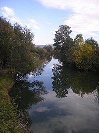
 Krupa river near Dračevo | |
 | |
| Location | |
| Country | Bosnia and Herzegovina |
| Municipality | Čapljina |
| Physical characteristics | |
| Source | |
| • location | Deransko Lake |
| Mouth | |
• location | Neretva |
• coordinates | 43°03′17″N 17°41′51″E / 43.0547°N 17.6974°E |
| Length | 9 km (5.6 mi) |
| Basin features | |
| Progression | Neretva→ Adriatic Sea |
The Krupa river is a left tributary of the river Neretva and the main water current of Hutovo Blato, which leads the waters from Gornje Blato and Svitavsko lake into the Neretva river near Dračevo. The length of Krupa is 9 km with an average depth of 5 meters. Krupa does not have an actual source, but is actually an arm of Deransko lake. Also, the Krupa is a unique river in Europe, because the river flows both ways. It flows 'normally' from the 'source' to the mouth and from the mouth to the 'source'. This happens when, due to high water level and large quantity of water, river Neretva pushes the Krupa river in opposite direction.[1]
See also
 Media related to Krupa (Neretva) at Wikimedia Commons
- Bregava
- Hutovo Blato
References
- ^ "Krupa river & Hutovo Blato – NAP – Network of Adriatic Parks". NAP – Network of Adriatic Parks. www.parksnap.eu. Retrieved 19 March 2009.[permanent dead link]
External links
- Krupa river & Hutovo Blato – NAP – Network of Adriatic Parks[permanent dead link]
- Hutovo Blato Nature Park
- Commission for Preservation of National Monuments of Bosnia and Herzegovina
- NGO for Environment protection ZELENI-NERETVA Konjic
- WWF Panda – Living Neretva
- REC Transboundary Cooperation Through the Management of Shared Natural Resources
- INWEB Internationally Shared Surface Water Bodies in the Balkan Region
- Narenta
- Wine route Herzegovina
- Čapljina municipality
- Neretva.org Open Project


