Ležáky

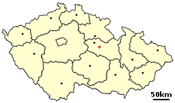
Ležáky (German: Ležak, from 1939: Lezaky), in the Miřetice municipality, was a village in Czechoslovakia. During the German occupation of Czechoslovakia, the village was completely razed by Nazi forces as reprisal for Reich Protector Reinhard Heydrich's assassination in late spring 1942.[1]
History
Ležáky was inhabited by poor stone-cutters and cottagers living in eight houses near the mill. The village was named after the Ležák rivulet.
Beginning 24 September 1941, SS-Obergruppenführer and General of Police Reinhard Heydrich was Acting Reichsprotektor for the Nazi Protectorate of Bohemia and Moravia.[2] The area had been occupied by Nazi Germany since 5 April 1939.[2]
In December 1941, several Allied paratroopers were dropped into the region. Some were sent to assassinate Reinhard Heydrich in an action known as Operation Anthropoid. Another group was part of Operation Silver A. Several Ležáky residents helped the latter group by providing a hiding place for their radio set.[3]
On the morning of 27 May 1942, Heydrich's car was attacked by Jozef Gabčík and Jan Kubiš, Czech and Slovak soldiers acting for the Czechoslovak government-in-exile.[4] Heydrich died on 4 June 1942.
Massacre

After the assassination, the Nazis imposed martial law. On 10 June, the village of Lidice was razed and all male inhabitants aged over 15 were shot. Lidice was selected because its residents were falsely accused of harbouring local resistance partisans and aiding Operation Anthropoid team members.[5]
Thereafter, Gestapo agents found a radio transmitter in Ležáky which belonged to Operation Silver A.[6] Alfréd Bartoš, the leader of resistance group Silver A, committed suicide shortly thereafter. On 24 June, approximately 500 SS troops and policemen surrounded Ležáky, removed all inhabitants, and the village was destroyed. All 33 adults (both men and women) were shot.[6] Thirteen children were spared. A 26 June press release announced the outcome. In mid-December 1943, the Ležáky ruins were removed by 65 men from Nazi work camps.[7]
Of the thirteen children, sisters Jarmila and Marie Šťulík were selected for "Germanization"; both were located and returned to their families after the war. The remaining eleven children were sent to the Chełmno extermination camp, where they were gassed in summer 1942, together with one girl from Lidice.[7]
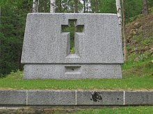
Unlike Lidice, Ležáky was not rebuilt after the war, and only memorials remain today.
See also
References
- ^ Gerwarth 2011, pp. 280, 285.
- ^ a b Kaplan and Nosarzewska, Prague: The Turbulent Century p. 214
- ^ Gerwarth 2011, pp. 280–285.
- ^ Kaplan and Nosarzewska, Prague: The Turbulent Century p. 241
- ^ Gerwarth 2011, p. 280.
- ^ a b Gerwarth 2011, p. 285.
- ^ a b "The History of Ležáky Memorial 1942 - 1943". Ležáky Memorial.
Literature
- Jarmila Doležalová (one of the two children that survived the war), František Vašek: Křižovatky času – Ležáky v datech (Crossroads of time - Ležáky in dates), 2007. History of the village since first written mention until today.
- Gerwarth, Robert (2011). Hitler's Hangman: The Life of Heydrich. New Haven, CT: Yale University Press. ISBN 978-0-300-11575-8.
{{cite book}}: Invalid|ref=harv(help) - Kaplan, Jan and Nosarzewska, Krystyna (1997). Prague: The Turbulent Century, Koenemann Verlagsgesellschaft mbH, Koeln. ISBN 3-89508-528-6
- Vojtěch Kyncl: Ležáky - Obyčejná vesnice, SILVER A a pardubické gestapo v zrcadle heydrichiády, 2009, (cz PDF), ISBN 978-80-7415-009-8
External links
- Official Website (cz,en,de,ru)
- Website dedicated to the village, photogallery (cz, en, de)
