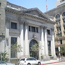
Main Street (Los Angeles)
| Length | 21 miles |
|---|---|
| South end | Lomita Boulevard near Wilmington |
| Major junctions |
|
| North end | Mission Road in Lincoln Heights, Los Angeles |


Main Street is a major north-south thoroughfare in Los Angeles, California. It serves as the east-west postal divider for the city and the county as well.[1]
Route
It begins as a continuation of Valley Boulevard west of Mission Road in Lincoln Heights as 'North Main Street'. The ends at the Port of Los Angeles. At 9th Street, it merges with Spring Street in Downtown LA, and between Cesar E. Chavez Avenue and 9th Street, Main Street shares a one-way couplet with Spring Street.
Main Street begins as a continuation of Wilmington Boulevard, a small street in the neighborhood of Wilmington, Los Angeles. Nearly 2 miles north at the intersection of Lomita Boulevard, it officially becomes Main Street and enters into the city of Carson.
Transportation
Main Street carries Metro Local lines 10, 33, 48, 55, 68, 76, 83, 92, and 355, as well as Metro Rapid line 733; most of those lines run on Main Street in downtown only, while Line 76 serves Main Street in Northeast Los Angeles and Line 48 in South Los Angeles.
"Los Angeles County, California" is an invalid category parameter for Template:Coord missing.
The problem is usually caused either by a spelling mistake or by an-over-precise category.
For a full list of categories, see Category:Unclassified articles missing geocoordinate data and its subcategories.
Notable landmarks
- Caltrans District 7 Headquarters
- Carrillo House
- Don Abel Stearns House
- The Downtown Independent (formerly Little Tokyo's Linda Lea Theatre)
- Farmers and Merchants Bank of Los Angeles building (former)
- LA Fashion District
- Hall of the Amigos del País
- Higgins Building
- Hotel Rosslyn Annex
- Lincoln Park
- Los Angeles City Hall
- Los Angeles Plaza Historic District
- Round House
- St. Vibiana's Cathedral
- Triforium
- United States Court House
References
