Makato
Appearance
Makato | |
|---|---|
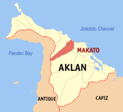
 Map of Aklan with Makato highlighted | |
| Country | Philippines |
| Region | Western Visayas (Region VI) |
| Province | Aklan |
| District | Lone district |
| Barangays | 18 |
| Government | |
| • Mayor | Abencio Torres |
| Area | |
| • Total | 64.60 km2 (24.94 sq mi) |
| Population (2010)[3] | |
| • Total | 25,461 |
| • Density | 390/km2 (1,000/sq mi) |
| Time zone | UTC+8 (PST) |
| Zip Code | 5611 |
| Dialing code | 36 |
Makato is a fourth class municipality in the province of Aklan, Philippines. According to the 2010 census, it has a population of 25,461 people.[3]
In 1948, the arrabal of Tangalan, comprising the barrios of Tondog, Jawili, Dumatad, Afga, Baybay, Dapdap, Pudyot, Tagas, Tamalagon, Panayakan, Vivo, Lanipga, Napatag and Tamoko, was separated from Makato to form the municipality of Tangalan.
Barangays
Makato is politically subdivided into 18 barangays.[2]
2
Demographics
| Year | Pop. | ±% p.a. |
|---|---|---|
| 1990 | 19,230 | — |
| 1995 | 21,955 | +2.51% |
| 2000 | 22,777 | +0.79% |
| 2007 | 25,043 | +1.32% |
| 2010 | 25,461 | +0.60% |
| Source: National Statistics Office[3] | ||
References
- ^ "Municipalities". Quezon City, Philippines: Department of the Interior and Local Government. Retrieved 5 February 2013.
- ^ a b "Province: Aklan". PSGC Interactive. Makati City, Philippines: National Statistical Coordination Board. Retrieved 5 February 2013.
- ^ a b c "Total Population by Province, City, Municipality and Barangay: as of May 1, 2010" (PDF). 2010 Census of Population and Housing. National Statistics Office. Retrieved 5 February 2013.
External links
