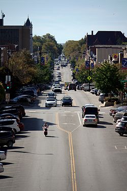
Massachusetts Street
Lawrence's Downtown Historic District | |
 Massachusetts Street through downtown | |
| Location | Along Massachusetts between Sixth and South Park Streets, Lawrence, Kansas |
|---|---|
| Coordinates | 38°57′59″N 95°14′10″W / 38.96639°N 95.23611°W |
| Area | 48.1 acres (19.5 ha) |
| Architect | Multiple |
| Architectural style | Late Victorian, Neoclassical architecture |
| MPS | Lawrence, Kansas MPS |
| NRHP reference No. | 04000685[1] |
| Added to NRHP | July 15, 2004 |
Massachusetts Street (or Mass Street) is a main thoroughfare through the central business district of downtown Lawrence, Kansas. It begins just south of the Kansas River at Sixth Street and continues south until reaching Haskell Indian Nations University. It takes its name from the Massachusetts Emigrant Aid Company, which founded Lawrence to populate the Kansas territory with Free-State (i.e., anti-slavery) advocates.[2] In 2014, Mass Street was named the most popular tourist attraction in Kansas by TripAdvisor.[3]


The 600 through 1200 block of Massachusetts is also listed on the National Register of Historical Places under Lawrence's Historical District. Most of the buildings were built between 1856 and 1953. Listed separately under the National Register are the Eldridge Hotel, the Douglas County Courthouse and Watkins National Bank (now Watkins Community Museum). Other listings along Mass Street but not located downtown are the Breezedale Historic District, the Goodrich House, the Edward House House, the Mackie House and the Roberts House (now the Castle Tea Room that was designed by Kansas State Capitol architect John G. Haskell).
Other historic businesses and sites of interest along Massachusetts Street are Liberty Hall, the Free State Brewing Company, Kansas' first legal brewery in over 100 years,[4] the Round Corner Pharmacy which was the longest-running pharmacy in the state until closing in 2009,[5] the House Building, the only downtown building to survive Quantrill's Raid, the Replay Lounge, the Granada, a former theater and popular music venue. There is also a Japanese Friendship Garden located next to the Watkins Museum, South Park, a city park established when Lawrence was founded in 1854 and Liberty Memorial Central Middle School, located in a former high school built in 1923.
See also
References
- ^ "National Register Information System". National Register of Historic Places. National Park Service. July 9, 2010.
- ^ "About the City". LawrenceKS.org. City of Lawrence. Retrieved 2014-05-29.
- ^ Nguyen, Vi-An (2014-05-24). "The Most Popular Tourist Attractions in All 50 States, According to TripAdvisor". Parade.Condenast.com. Parade Publications. Retrieved 2014-05-29.
- ^ "Free State - About". The Free State Brewing Company. Retrieved June 3, 2011.
- ^ Fagan, Mark (July 8, 2009). "Round Corner Drug, Cheese Shoppe closes". LJWorld.com. The World Company. Retrieved June 3, 2011.


