
Mount Revelstoke National Park
This article needs additional citations for verification. (June 2010) |
| Mount Revelstoke National Park | |
|---|---|
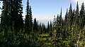
 Meadow near the summit | |
_location_map.svg) Location in British Columbia | |
| Location | Revelstoke, British Columbia, Canada |
| Coordinates | 51°05′09″N 118°03′56″W / 51.08583°N 118.06556°W |
| Area | 260 km2 (100 sq mi) |
| Established | 1914 |
| Visitors | approx. 500,000 (in each year) |
| Governing body | Parks Canada |
Mount Revelstoke National Park is located adjacent to the city of Revelstoke, British Columbia, Canada. The park is relatively small for a national park, covering 260 km2 (100 sq mi). It is located in the Selkirk Mountains and was founded in 1914. Approximately 600,000 visitors enter Mount Revelstoke and nearby Glacier National Park each year.
Climate
The park contains a portion of one of the world's few inland temperate rain forests. Steep, rugged mountains can be found in a warm, moist climate. A variety of plant and animal life is typical with stands of old-growth Western Redcedar and Western Hemlock, a forest type which is rapidly declining outside of protected areas. The park's inland rainforest also has an isolated population of banana slugs which marks the eastern boundary of their distribution in North America.
Fauna
This national park protects a small herd of the threatened woodland caribou as well as providing habitats for cougars, grizzly bears, lynxes, black bears, red foxes, moose, martens, coyotes, a variety of bats, wolf packs, several species of shrews, voles, mice, wolverines, and mountain goats.
Tourism
The Meadows-in-the-Sky Parkway is a paved mountain road open during the snow free months. The parkway begins in the rainforests of the park’s southwest corner, winds upward through the sub-alpine forests and ends in the rolling sub-alpine wildflower meadows. The Monashee Mountains rise to the west, with the Selkirk range to the east.
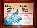
Giant Cedars Boardwalk is a 500 m. (0.3 mi.) interpretive trail that twists through a stand of old-growth western red cedar and hemlock trees, some more than 800 years old. Exhibits along the way explore the secrets of this inland rainforest.
Skunk Cabbage Boardwalk is a 1.2 km. (0.75 mi.) interpretive trail that leads through valley bottom rainforest and fragile wetlands inhabited by muskrats, beavers, bears and the strange skunk cabbage plant. Exhibits also help to identify the many birds that migrate from South and Central America to the Skunk Cabbage area each year.
Gallery
-
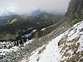
 North of lake Balsam
 -
 View from Eva Lakes Trail
 -
 Miller Lake from Jade Lakes Trail
 -
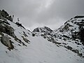 Jade Pass in early September
 -
 View of Revelstoke from the summit
 -
 Giant Cedars Boardwalk Trail
 -
 Giant Cedars Boardwalk Trail
 -
 Giant Cedars Boardwalk Trail
 -
 Giant Cedars Boardwalk Trail
 -
 Giant Cedars Boardwalk Trail
 -
 Giant Cedars Boardwalk Trail


See also
References
External links
| International | |
|---|---|
| National | |