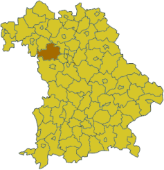
Neustadt (Aisch)-Bad Windsheim
Neustadt (Aisch)-Bad Windsheim | |
|---|---|
 | |
| Country | Germany |
| State | Bavaria |
| Adm. region | Mittelfranken |
| Capital | Neustadt (Aisch) |
| Area | |
| • Total | 1,267.54 km2 (489.40 sq mi) |
| Population (31 December 2022)[1] | |
| • Total | 103,303 |
| • Density | 81/km2 (210/sq mi) |
| Time zone | UTC+01:00 (CET) |
| • Summer (DST) | UTC+02:00 (CEST) |
| Vehicle registration | NEA, SEF, UFF |
| Website | http://www.landkreis-nea.de |
Neustadt (Aisch)-Bad Windsheim (German: Landkreis Neustadt an der Aisch-Bad Windsheim, official Landkreis Neustadt a.d.Aisch-Bad Windsheim) is a district in Bavaria, Germany. It is bounded by (from the west and clockwise) the districts of Würzburg, Kitzingen, Bamberg, Erlangen-Höchstadt, Fürth and Ansbach, and by the state of Baden-Württemberg (district Main-Tauber).
History
The district was established in 1972 by merging the former districts of Neustadt (Aisch), Uffenheim and Scheinfeld.
Geography
The district is covered by the Steigerwald and Frankenhöhe nature parks, both comprising large forested and hilly areas. The Aisch, a small affluent of the Regnitz River, runs through the district from southwest to northeast, with all main towns of the district on its banks.
Coat of arms
The coat of arms displays:
|
Towns and municipalities
Towns:
Municipalities:
- Baudenbach
- Burghaslach
- Dachsbach
- Diespeck
- Dietersheim
- Emskirchen
- Ergersheim
- Gallmersgarten
- Gerhardshofen
- Gollhofen
- Gutenstetten
- Hagenbüchach
- Hemmersheim
- Illesheim
- Ippesheim
- Ipsheim
- Langenfeld
- Markt Bibart
- Markt Erlbach
- Markt Nordheim
- Markt Taschendorf
- Marktbergel
- Münchsteinach
- Neuhof an der Zenn
- Oberickelsheim
- Obernzenn
- Oberscheinfeld
- Simmershofen
- Sugenheim
- Trautskirchen
- Uehlfeld
- Weigenheim
- Wilhelmsdorf
References
- ^ Genesis Online-Datenbank des Bayerischen Landesamtes für Statistik Tabelle 12411-003r Fortschreibung des Bevölkerungsstandes: Gemeinden, Stichtag (Einwohnerzahlen auf Grundlage des Zensus 2011) (Hilfe dazu).
External links
- Official website (German)
