Papendrecht
Papendrecht | |
|---|---|
 Drawbridge in Papendrecht | |
 Location in South Holland | |
| Country | Netherlands |
| Province | South Holland |
| Government | |
| • Body | Municipal council |
| • Mayor | Kees de Bruin (VVD) |
| Area | |
| • Total | 10.79 km2 (4.17 sq mi) |
| • Land | 9.41 km2 (3.63 sq mi) |
| • Water | 1.38 km2 (0.53 sq mi) |
| Elevation | −1 m (−3 ft) |
| Population (January 2021)[4] | |
| • Total | 32,171 |
| • Density | 3,419/km2 (8,860/sq mi) |
| Demonym | Papendrechter |
| Time zone | UTC+1 (CET) |
| • Summer (DST) | UTC+2 (CEST) |
| Postcode | 3350–3356 |
| Area code | 078 |
| Website | www |
Papendrecht () is a town and municipality in the western Netherlands, in the province of South Holland, at the crossing of the River Beneden Merwede and the Noord River. The municipality had a population of 32,171 in 2021 and covers an area of 10.79 km2 (4.17 sq mi) of which 1.38 km2 (0.53 sq mi) is water.
Although Papendrecht is first mentioned in documents dating back to 1105, it remained a small settlement until the 1950s. In the 1960s its development accelerated and almost its entire area is now urbanized. It is, however, known for its 180-year-old linden tree by the river.

Topography
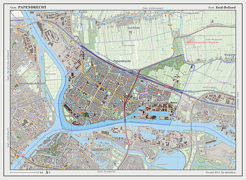
Dutch Topographic map of the municipality of Papendrecht, 2013.
Transportation
Papendrecht has two Water taxi stops, one at the Beneden Merwede River, and one at the Noord River. The entire trajectory of the Water taxi is:
- Dordrecht Merwekade
- Dordrecht Hooikade
- Zwijndrecht Veerplein
- Papendrecht Veerdam
- Papendrecht Oosteind
- Hollandse Biesbosch
- Sliedrecht Middeldiep
Papendrecht also has a relatively high density of bus connections, mostly provided by Arriva.
References
- ^ "Burgemeester de Bruin" (in Dutch). Gemeente Papendrecht. Retrieved 18 August 2013.
{{cite web}}: Unknown parameter|trans_title=ignored (|trans-title=suggested) (help) - ^ "Kerncijfers wijken en buurten 2020" [Key figures for neighbourhoods 2020]. StatLine (in Dutch). CBS. 24 July 2020. Retrieved 19 September 2020.
- ^ "Postcodetool for 3351PB". Actueel Hoogtebestand Nederland (in Dutch). Het Waterschapshuis. Retrieved 18 August 2013.
{{cite web}}: Cite has empty unknown parameter:|trans_title=(help) - ^ "Bevolkingsontwikkeling; regio per maand" [Population growth; regions per month]. CBS Statline (in Dutch). CBS. 1 January 2021. Retrieved 2 January 2022.


