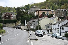
Ponsanooth
This article needs additional citations for verification. (November 2011) |
Ponsanooth
| |
|---|---|
 | |
Location within Cornwall | |
| Area | 0.4175 km2 (0.1612 sq mi) |
| Population | 1,184 (2019 estimate) |
| • Density | 2,836/km2 (7,350/sq mi) |
| OS grid reference | SW755375 |
| Civil parish |
|
| District | |
| Shire county | |
| Region | |
| Country | England |
| Sovereign state | United Kingdom |
| Post town | Truro |
| Postcode district | TR3 |
| Dialling code | 01872 |
| Police | Devon and Cornwall |
| Fire | Cornwall |
| Ambulance | South Western |
Ponsanooth (Cornish: Pons an Woodh,[1] meaning "bridge at the stream")[2] is a village and civil parish in Cornwall, England, United Kingdom. It is about four miles southeast of Redruth and two and a half miles northwest of Penryn on the A393 road Redruth to Falmouth road. In 2019 it had an estimated population of 1184.[3]
The church of St Michael and All Angels is now part of a larger benefice, sharing a single vicar with Mabe. Also the village has a shop which includes a post office, village hall, primary school [4] and a public house called The Stag Hunt[5]
The River Kennall runs nearby: in the 19th century, this river worked a flour mill and a number of gunpowder mills (http://cornishstory.com/2021/05/17/kennall-gunpowder-mill-co/), machinery at a foundry, and a paper mill. The gunpowder mills supplied many of the mines of west Cornwall until 1910, by which time gunpowder had been largely replaced by high explosives. The site of one of the ruined mills is now within a Nature Reserve. Frederick Hamilton Davey the botanist (died 23 September 1915) was born at Ponsanooth and was buried in the Wesleyan Cemetery there.
Civil parish
Until 1 April 2021 the civil parish was called St Gluvias[6] which doesn't include the Penryn suburb St Gluvias. The parish population at the 2011 census was 1,668.[7]
References
- ^ Place-names in the Standard Written Form (SWF) Archived 15 May 2013 at the Wayback Machine : List of place-names agreed by the MAGA Signage Panel Archived 15 May 2013 at the Wayback Machine. Cornish Language Partnership.
- ^ Weatherhill, Craig (2009) A Concise Dictionary of Cornish Place-names. Westport, Mayo: Evertype; p. 57
- ^ "Ponsanooth". City Population De. Retrieved 6 July 2021.
- ^ "Kennall Vale School". Kennall-vale.cornwall.sch.uk. Retrieved 16 May 2015.
- ^ "The Stag Hunt Inn at Ponsanooth - Homepage". Staghuntinnponsanooth.net. Retrieved 16 May 2015.
- ^ "The Cornwall (Reorganisation of Community Governance) No. 1 Order 2020" (PDF). Local Government Boundary Commission for England. Retrieved 6 July 2021.
- ^ "population census 2011". Archived from the original on 8 February 2015. Retrieved 8 February 2015.

