Prachinburi province
This article is written like a travel guide. (January 2015) |
Prachin Buri
ปราจีนบุรี | |
|---|---|
 Map of Thailand highlighting Prachin Buri Province | |
| Country | |
| Capital | Prachinburi town |
| Government | |
| • Governor | Siriphong Hantrakun (since 2009) |
| Area | |
| • Total | 4,762.4 km2 (1,838.8 sq mi) |
| • Rank | Ranked 45th |
| Population (2014) | |
| • Total | 479,314[1] |
| • Rank | Ranked 61st |
| • Rank | Ranked 51st |
| Time zone | UTC+7 (ICT) |
| ISO 3166 code | TH-25 |
Prachin Buri (Thai: ปราจีนบุรี) is a province (changwat) of Thailand. Neighboring provinces are (from north clockwise) Nakhon Ratchasima, Sa Kaeo, Chachoengsao, and Nakhon Nayok.
Geography
The province is divided into two major parts, the low river valley of the Prachin Buri River, and the higher lands with plateaus and mountains of the Sankamphaeng Range, the southern prolongation of the Dong Phaya Yen mountains. In those areas are also two national parks, Khao Yai and Tab Larn National Park.
Climate
| Climate data for Prachinburi(1981–2010) | |||||||||||||
|---|---|---|---|---|---|---|---|---|---|---|---|---|---|
| Month | Jan | Feb | Mar | Apr | May | Jun | Jul | Aug | Sep | Oct | Nov | Dec | Year |
| Mean daily maximum °C (°F) | 33.2 (91.8) |
34.9 (94.8) |
36.3 (97.3) |
36.8 (98.2) |
35.1 (95.2) |
33.8 (92.8) |
33.2 (91.8) |
32.8 (91.0) |
32.7 (90.9) |
32.7 (90.9) |
32.7 (90.9) |
32.2 (90.0) |
33.9 (93.0) |
| Mean daily minimum °C (°F) | 20.7 (69.3) |
22.7 (72.9) |
24.3 (75.7) |
25.4 (77.7) |
25.3 (77.5) |
25.2 (77.4) |
24.9 (76.8) |
24.9 (76.8) |
24.7 (76.5) |
24.5 (76.1) |
23.0 (73.4) |
20.5 (68.9) |
23.8 (74.9) |
| Average rainfall mm (inches) | 7.7 (0.30) |
15.8 (0.62) |
49.9 (1.96) |
118.0 (4.65) |
231.0 (9.09) |
223.5 (8.80) |
271.9 (10.70) |
358.5 (14.11) |
349.4 (13.76) |
160.9 (6.33) |
31.7 (1.25) |
5.0 (0.20) |
1,823.3 (71.77) |
| Average rainy days (≥ 1 mm) | 1 | 2 | 5 | 10 | 18 | 19 | 21 | 23 | 21 | 15 | 4 | 1 | 140 |
| Average relative humidity (%) | 65 | 67 | 69 | 73 | 79 | 81 | 82 | 82 | 83 | 78 | 68 | 63 | 74 |
| Source: Thai Meteorological Department (Normal 1981-2010), (Avg. rainy days 1961-1990) | |||||||||||||
Symbols
The provincial seal shows the Bodhi tree. It symbolizes the first Bodhi tree planted about 2,000 years ago in the temple Wat Si Maha Phot. The provincial colors are red and yellow. Red symbolises the land and yellow, Buddhism.
The provincial tree is the Bodhi tree (Ficus religiosa). The provincial flower is the cork tree (Millingtonia hortensis).
Administrative divisions
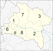
The province is divided into seven districts (amphoe). These are further subdivided into 65 sub-districts (tambon) and 658 villages (muban).
|
The missing numbers 4 and 5 as well as 10 to 12 are the districts split off to form Sa Kaeo Province.
References
- ^ "Population of the Kingdom" (PDF). Department of Provincial Affairs (DOPA) Thailand (in Thai). 2014-12-31. Retrieved 19 Mar 2015.
External links
 Prachinburi travel guide from Wikivoyage
- Provincial Website[dead link]
- Prachinburi from the Tourism Authority of Thailand
- Khao Yai National Park


