Sainte Rose du Lac
Appearance
Sainte Rose du Lac | |
|---|---|
| Nickname: Cattle Capital of Manitoba | |
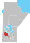
Location of Dauphin in Manitoba | |
| Coordinates: 51°03′34″N 99°31′24″W / 51.05944°N 99.52333°W | |
| Country | Canada |
| Province | Manitoba |
| Region | Parkland |
| Established | 1889 |
| Incorporated (village) | May 25, 1920 |
| Incorporated (town) | March 20, 1998 |
| Amalgamated | January 1, 2015 |
| Government | |
| • MP (Dauphin—Swan River—Marquette) | Robert Sopuck |
| • MLA (Dauphin) | Stan Struthers |
| Area | |
| • Total | 2.53 km2 (0.98 sq mi) |
| Population (2011) | |
| • Total | 1,023 |
| • Density | 404.2/km2 (1,047/sq mi) |
| • Change 2006-11 | |
| Time zone | UTC−6 (CST) |
| • Summer (DST) | UTC−5 (CDT) |
Sainte Rose du Lac (often abbreviated Ste Rose du Lac) is an unincorporated urban community in the Municipality of Ste. Rose within the Canadian province of Manitoba that held town status prior to January 1, 2015. It is located approximately 50 km east-southeast of Dauphin, Manitoba and approximately 300 km west-northwest of Winnipeg. It had a population of 1,023 as of the Canada 2011 Census.
It is served by Laurier railway station and Sainte Rose du Lac Airport.
Demographics
| Census | Population | Change (%) |
|---|---|---|
| 2011 | 1,023 | |
| 2006 | 995 | |
| 2001 | 1,047 | N/A |
| 1996 | 1,047 |
| Religion | Population | Pct (%) |
|---|---|---|
| Catholic | 605 | 62.05% |
| Protestant | 220 | 22.56% |
| No religious affiliation | 150 | 15.38% |
|
|
Media
CKSB-1 first went on the air as CBKB on the AM frequency of 860 kHz on February 1, 1968.
- CKSB-1 92.9


