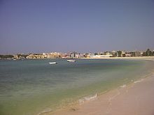
Sal Rei
Sal Rei | |
|---|---|
Settlement | |
 Aerial view of Sal Rei | |
| Coordinates: 16°10′37″N 22°55′05″W / 16.177°N 22.918°W | |
| Country | Cape Verde |
| Island | Boa Vista |
| Municipality | Boa Vista |
| Civil parish | Santa Isabel |
| Population (2010)[1] | |
| • Total | 5,778 |
| Postal code | 5110 |
| ID | 51205 |
Sal Rei is a city[2] on the northwestern coast of the island of Boa Vista in eastern Cape Verde. Sal Rei is the island's main urban settlement, and the seat of the Boa Vista Municipality. In 2010 its population was 5,778. The name of the settlement means "Salt King" in Portuguese. This name stems from when the island's main industry was salt production.
Sal Rei has a port on the bay with ferry routes to the islands of Santiago (Praia), Sal (Santa Maria) and Maio (Cidade do Maio). A new quay was built in 2015.[3] West of the port lies the small islet of Ilhéu de Sal Rei. Tourism is concentrated on the area of Praia de Cabral.
History
[edit]
The town was founded in the saltpans of Boa Vista. In 1815 and 1817, the town was sacked by pirates. Forte Duque de Bragança was built on the nearby island Ilhéu de Sal Rei to defend the town from further pirate attacks.
Population
[edit]| Population of the town of Sal Rei (1990–present) | ||
|---|---|---|
| 1991[4] | 2000[4] | 2010[4] |
| 1,522 | 1,995 | 5,778 |
Climate
[edit]Sal Rei is in a desert climate zone as does the rest of the island. Its average rainfall is 67 mm (2.6 in), and its average temperature is 24.1 °C (75.4 °F). The coldest month is February which averages 21.7 °C (71.1 °F) and the warmest is September which averages 27.2 °C (81.0 °F).[5]
| Climate data for Sal Rei, 7 metres ASL | |||||||||||||
|---|---|---|---|---|---|---|---|---|---|---|---|---|---|
| Month | Jan | Feb | Mar | Apr | May | Jun | Jul | Aug | Sep | Oct | Nov | Dec | Year |
| Mean daily maximum °C (°F) | 25 (77) |
25 (77) |
26 (79) |
26 (79) |
27 (81) |
27 (81) |
28 (82) |
29 (84) |
30 (86) |
29 (84) |
28 (82) |
26 (79) |
27 (81) |
| Mean daily minimum °C (°F) | 19 (66) |
18 (64) |
19 (66) |
20 (68) |
20 (68) |
21 (70) |
23 (73) |
23 (73) |
24 (75) |
24 (75) |
22 (72) |
20 (68) |
21 (70) |
| Average rainfall mm (inches) | 2 (0.1) |
0 (0) |
0 (0) |
0 (0) |
0 (0) |
0 (0) |
3 (0.1) |
16 (0.6) |
38 (1.5) |
7 (0.3) |
0 (0) |
1 (0.0) |
67 (2.6) |
| Source: Climate-Data.ORG[5] | |||||||||||||

Notable people
[edit]- Aristides Raimundo Lima, president of the National Assembly from 2001 to 2011.[6]
See also
[edit]References
[edit]- ^ "2010 Census results". Instituto Nacional de Estatística Cabo Verde (in Portuguese). 24 November 2016.
- ^ Cabo Verde, Statistical Yearbook 2015, Instituto Nacional de Estatística, p. 32-33
- ^ "Porto Sal Rei (also as Porto da Boa Vista)" (in Portuguese). ENAPOR. Retrieved 18 February 2017.
- ^ a b c citypopulation.de
- ^ a b Sal Rei climate data, accessed 218-08-02
- ^ "Biography at the National Assembly website" (PDF). in pdf


