
Serekunda
Serekunda | |
|---|---|
City | |
 | |
 Serekunda Location in the Gambia | |
| Coordinates: 13°26′N 16°40′W / 13.433°N 16.667°W | |
| Country | The Gambia |
| Division | Banjul |
| Population | |
| • Total | ~ 337,000 |
Serekunda (Arabic: سيريكوندا, sometimes spelled Serrekunda) is the largest urban centre in The Gambia.[2]
It is situated close to the Atlantic coast, 13 km (8 mi) south-west of the capital, Banjul,[3] and is formed of nine villages which have grown together into a larger urban area.
Serekunda means "home of the Sayer [or Sayerr] family" and is named after its founder, Sayerr Jobe.[3]
Population history
| 1973 | 1983 | 1993 | 2007 |
|---|---|---|---|
| 25 505 | 70 435 | 194 987 | 348 118 [1] |
-

-

-
-
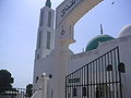
 Mosque on Bundung Highway
 -
-


References
- ^ a b "Gambia town information".
- ^ "Introducing Serekunda & the Atlantic Coast". Lonely Planet. Retrieved 29 May 2014.
- ^ a b "Serrekunda Town, Gambia". Access Gambia. Retrieved 2015-07-15.
External links
13°26′N 16°40′W / 13.433°N 16.667°W
Wikimedia Commons has media related to Serekunda.
Wikivoyage has a travel guide for Serekunda.
This Gambian location article is a stub. You can help Wikipedia by expanding it. |