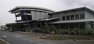
Serendah Komuter station
KA11 Serendah Commuter Station Stesen Komuter Serendah 双文丹火车站 | |||||||||||
|---|---|---|---|---|---|---|---|---|---|---|---|
 The main entrance of the Serendah station. | |||||||||||
| General information | |||||||||||
| Location | Serendah, Selangor, Malaysia. | ||||||||||
| Owned by | Keretapi Tanah Melayu | ||||||||||
| Line(s) | Rawang-Seremban Route (KTM Komuter). | ||||||||||
| Platforms | 2 side platforms. | ||||||||||
| Tracks | 2 | ||||||||||
| Construction | |||||||||||
| Parking | Available, free. | ||||||||||
| Accessible | Yes | ||||||||||
| History | |||||||||||
| Opened | 1893 | ||||||||||
| Rebuilt | April 21, 2007 | ||||||||||
| Electrified | April 21, 2007 | ||||||||||
| Services | |||||||||||
| |||||||||||
The Serendah Komuter station is a Malaysian commuter train station stationed roughly two kilometres northwest from and named after the town of Serendah, Selangor. The station is located on the KTM West Coast Line.

It was previously built as KTM Intercity's Serendah railway halt. The station was opened on April 21, 2007 alongside the Rasa and Batang Kali stations, and is the first stop in the Rawang-Tanjung Malim shuttle service (formerly known as the Rawang-Kuala Kubu Bharu shuttle service). No KTM Intercity trains stop at this station.
The station, as are all the other stations along the shuttle route (except the Tanjung Malim Komuter station), is situated along two railways, each assigned with one platform like most station halts along KTM Komuter lines, but contains facilities normally reserved for medium-to-large stations along three or more lines. In addition to ticketing facilities and basic amenities, the station contains spaces for administrative occupants, as well as a "kiosk" and an additional foot bridge (fused with a foot bridge exclusively for Komuter users) for pedestrians that simply intend to cross the railway lines. The station also includes low-tech support for disabled passengers. The station exits northeast towards a road, which reaches the town of Serendah an estimated two kilometres south.
The Serendah station's two side platforms are designated as platform 1 (adjoining the main station building at the east, intended for southbound trains) and platform 2 (at the west, intended for northbound trains).
History

The West Coast Line reached Serendah in 1893 when the stretch between the town and Rawang to the south was completed and opened to traffic.
Prior to the Rawang-Ipoh Electrification and Double-Tracking Project, the old Serendah railway station was located in town, accessed by a side road running westwards from the main road at the police station. There are no records as to whether this station, a masonry building, was the first station at Serendah, and whether the station was built and completed together with the opening of the railway line in 1893.
The old masonry station had one main track and a loop for trains to pass along the single track. There were also sidings for stabling of freight wagons to the south of the station. One unique feature was that the station was located on the first loop track and not the main line, resulting in trains which are channeled into the loop stopping at the station platform.
The old station was not a stop for passenger trains and used mostly for trains to pass.
The old station was demolished under the Rawang-Ipoh Electrification and Double-Tracking Project between 2002 and 2007, as the location was required for the future double tracks. In its place, the new Serendah Komuter Station was built about 2 km away near Kampung Seri Serendah. The station became a stop on the KTM Komuter Rawang-Tanjung Malim Shuttle Service on April 21, 2007.
References
- "KTM Komuter Services For Rawang - Rasa Sector Launched". Official Keretapi Tanah Melayu website. April 21, 2007. Archived from the original on 2007-08-10. Retrieved 2007-05-03.
