Simpson Copple House
Appearance
Simpson Copple House | |
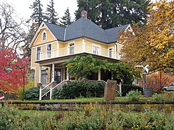
 The Copple House in 2009 | |
| Location | 911 Montello Avenue Hood River, Oregon |
|---|---|
| Coordinates | 45°42′19″N 121°31′14″W / 45.705212°N 121.520422°W |
| Area | Less than 1 acre (0.40 ha)[1] |
| Built | 1906 |
| Architectural style | Vernacular Queen Anne, with a Colonial Revival porch[1] |
| NRHP reference No. | 87000362 |
| Added to NRHP | March 6, 1987 |
The Simpson Copple House is a historic residence in Hood River, Oregon, United States. Built in 1906 on a rise overlooking the Columbia River, it is one of the best preserved examples of the vernacular, late Queen Anne architectural style in Hood River. Its size, state of preservation, and fine detail work on its gables especially stand out from similar houses in the area. Simpson Copple (1842–1933) was a Civil War veteran and pioneer orchardist who was important in the growth of the apple industry in the Hood River Valley. He purchased the house shortly after its construction and lived there until his death.[1]
The house was listed on the National Register of Historic Places in 1987.[2]
See also
[edit]References
[edit]- ^ a b c Zisman, Karen; Grimala, Barbara (August 14, 1986), National Register of Historic Places Inventory — Nomination Form: Copple, Simpson, House (PDF), retrieved January 7, 2015.
- ^ Oregon Parks and Recreation Department, Oregon Historic Sites Database, retrieved January 7, 2015.
External links
[edit]
Categories:
- 1906 establishments in Oregon
- Buildings and structures in Hood River, Oregon
- Houses completed in 1906
- Houses in Hood River County, Oregon
- Houses on the National Register of Historic Places in Oregon
- National Register of Historic Places in Hood River County, Oregon
- Queen Anne architecture in Oregon
- Oregon Registered Historic Place stubs


