South Geelong, Victoria
| South Geelong Geelong, Victoria | |||||||||||||||
|---|---|---|---|---|---|---|---|---|---|---|---|---|---|---|---|
 | |||||||||||||||
| Population | 15,420 (2006)[1] | ||||||||||||||
| Postcode(s) | 3220 | ||||||||||||||
| Location | 2 km (1 mi) from Geelong | ||||||||||||||
| LGA(s) | City of Greater Geelong | ||||||||||||||
| State electorate(s) | Geelong | ||||||||||||||
| Federal division(s) | Corio | ||||||||||||||
| |||||||||||||||
South Geelong, also referred to as Geelong South, is a southern suburb of Geelong, Victoria, Australia. The suburb is adjacent to the Geelong central business district, with the Barwon River forming the suburb's southern border. South Geelong is also the western end-point for the Bellarine Rail Trail, a 32 km walking and cycling track to Queenscliff.
Major industry in South Geelong includes the Godfrey Hirst Pty Ltd carpet manufacturers on Barwon Terrace currently (2009) owned by the McKendrick family.
The Post Office opened on 1 June 1921 as South Geelong and was renamed Geelong South in 1941.[2]
Sporting facilities
John Landy Athletic Field is located on the corner of Barwon Terrace and Swanston Street. Developed in the early 1960s and opened for competition in late 1961, Landy Field is home to the Little Athletics movement developed by Geelong resident Trevor Billingham B.E.M..
Landy Field is home to Geelong Athletics, the Geelong Little Athletics Centre and the Geelong Masters group. The venue is managed by the John Landy Field Management Committee under a licence agreement with the Geelong Council.
See also
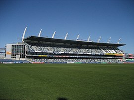
- Kardinia Park, public park on the western edge of the suburb
- Kardinia Park, home ground of the Geelong Football Club
- South Geelong railway station
Gallery
-
The old South Geelong Gaol (1933)
-
Austin Hall
-
Austin Hall and clocktower
-
Austin Terraces
References
- ^ Australian Bureau of Statistics (25 October 2007). "South Geelong (State Suburb)". 2006 Census QuickStats. Retrieved 2007-10-01.
- ^ Premier Postal History, Post Office List, retrieved 2008-04-11
External links


