
Sovetsk, Kaliningrad Oblast
Sovetsk
Советск | |
|---|---|
 The old town of Sovetsk, with German-era buildings | |
.png) Flag  Coat of arms | |
Location of Sovetsk  | |
 Sovetsk Location of Sovetsk  Sovetsk Sovetsk (Kaliningrad Oblast) | |
| Coordinates: 55°4′51″N 21°53′11″E / 55.08083°N 21.88639°E | |
| Country | Russia |
| Federal subject | Kaliningrad Oblast |
| Founded | 1288 |
| Town status since | 1552 |
| Government | |
| • Head | Viktor Smilgin |
| Elevation | 10 m (30 ft) |
| Population | |
| • Total | 41,705 |
| • Estimate (2018)[2] | 39,752 (−4.7%) |
| • Subordinated to | town of oblast significance of Sovetsk[3] |
| • Capital of | town of oblast significance of Sovetsk[3] |
| • Urban okrug | Sovetsky Urban Okrug[4] |
| • Capital of | Sovetsky Urban Okrug[4] |
| Time zone | UTC+2 (MSK–1 |
| Postal code(s)[6] | 238750 |
| Dialing code(s) | +7 40161 |
| OKTMO ID | 27730000001 |
| Website | sovetsk-tilsit |
Sovetsk (Russian: Сове́тск), before 1946 known as Tilsit in East Prussia (Lithuanian: Tilžė, Polish: Tylża), is a town in Kaliningrad Oblast, Russia, located on the south bank of the Neman River. Population: 41,705 (2010 Russian census);[1] 43,224 (2002 Census);[7] 41,881 (1989 Soviet census).[8]
Geography
Sovetsk lies at the confluence of the Tilse (Russian: Тыльжа Tylzha, Lithuanian Tilže) with the Neman.
History
Teutonic Order 1288–1466
Duchy of Prussia 1525–1657 (fief of Poland)
Kingdom of Prussia 1701–1871
German Empire 1871–1918
Weimar Republic 1918–1933
Nazi Germany 1933–1945
Soviet Union 1945–1991
Russian Federation 1991–present

Tilsit, which received civic rights in 1552, grew up around a castle of the Teutonic Knights, known as the Schalauner Haus, founded in 1288. The Treaties of Tilsit were signed here in July 1807, the preliminaries of which were settled by the emperors Alexander I of Russia and Napoleon I of France on a raft moored in the Neman River. This treaty, which created the Kingdom of Westphalia and the Duchy of Warsaw, completed Napoleon's humiliation of the Kingdom of Prussia, when it was deprived of one half of its dominions.
This short-lived peace-treaty is also remarkable for quite another reason. Three days before its signing, Prussian queen Louise (1776–1810) tried to persuade Napoleon in a private conversation to ease his hard conditions on Prussia. Though unsuccessful, Louise's effort greatly endeared her to the Prussian people.
Until 1945, a marble tablet marked the house in which King Frederick William III of Prussia and Queen Louise resided. Also, in the former Schenkendorf Platz was a monument to the poet Max von Schenkendorf (1783–1817) a native of Tilsit. During the 19th century when the Lithuanian language was banned within the Russian Empire, Tilsit was an important centre for printing Lithuanian books which then were smuggled by Knygnešiai to the Russian-controlled part of Lithuania. In general, Tilsit thrived and was an important Prussian town. By 1900 it had electric tramways and 34,500 inhabitants; a direct railway line linked it to Königsberg and Labiau and steamers docked there daily. It was occupied by Russian troops between 26 August 1914 and 12 September 1914 during World War I. The Act of Tilsit was signed here by leaders of the Lietuvininks in 1918.
According to German data in 1890 35% of the Tilsit district (which Tilsit was not part of) population was composed of Lithuanians.
Hitler visited the town just before World War II, and a photo was taken of him on the famous bridge over the Memel River. Tilsit was occupied by the Red Army on January 20, 1945, and was annexed by the Soviet Union in 1945. The remaining Germans who had not evacuated were subsequently forcibly expelled and replaced with Soviet citizens. The town was renamed Sovetsk by the new communist rulers, in honor of Soviet rule.
Modern Sovetsk has sought to take advantage of Tilsit's rich traditions of cheese production (Tilsit cheese), but the new name ("Sovetsky cheese") has not inherited its predecessor's reputation.
In April 2007, government restrictions on visits to border areas have been tightened, and for foreigners, and Russians living outside the border zone, travel to the Sovetsk and Bagrationovsk areas required advance permission from the Border Guard Service (in some cases up to 30 days beforehand). It was alleged that this procedure slowed the development of these potentially thriving border towns.[9] In June 2012, these restrictions were lifted (the only restricted area is the Neman river shoreline), which gave boost to local and international tourism.
Administrative and municipal status
Within the framework of administrative divisions, it is incorporated as the town of oblast significance of Sovetsk—an administrative unit with the status equal to that of the districts.[3] As a municipal division, the town of oblast significance of Sovetsk is incorporated as Sovetsky Urban Okrug.[4]
Architecture
Many of the town's buildings were destroyed during World War II. However, the old town centre still includes several German buildings, including those of Jugendstil design. The Queen Louise Bridge, now connecting the town to Panemunė/Übermemel in Lithuania, retains an arch – all that is left of a more complex pre-war bridge structure.
Historical population
- 1880: 21,400
- 1900: 34,539
- 1910: 39,013
- 1925: 50,834
- 1933: 57,286
- 1939: 59,105
- 1946: 6,500
- 1989 Census: 41,881[8]
- 2002 Census: 43,224[7]
- 2004: 43,300
- 2010 Census: 41,705[1]
Ethnic composition in 2010:
- Russians — 86,7 %,
- Ukrainians — 3,5 %
- Lithuanians — 3,3 %
- Belarusians — 2,7 %
International relations
Twin towns and sister cities
Sovetsk is twinned with:
Notable people
- Daniel Klein (1609–1666), Lithuanian pastor and grammarian
- Max von Schenkendorf (1783–1817), German poet and author
- Franz Meyen (1804–1840), German botanist
- Hans Victor von Unruh (1806–1886), German politician and technician
- Wilhelm Voigt (1849–1922), the inspiration for The Captain of Köpenick
- Gustaf Kossinna or Kossina (1858–1931), archaeologist
- Johanna Wolff (1858–1943), German author
- Emil Wiechert (1861–1928), German geophysicist
- Raphael Friedeberg (1863–1940), German physician and politician
- Max Gülstorff (1882–1947), German actor
- Carl Brinkmann (1885–1954), German sociologist and economist
- Frank Wisbar (1899–1967) German director
- Karl Hermann Martell (1906–1966), German actor
- Joachim Sadrozinski (1907–1944), officer and resistance fighter
- Siegfried Graetschus (1916–1943), SS-Oberscharführer, killed during revolt in Sobibor extermination camp
- Johannes Bobrowski (1917–1965), German writer
- Jürgen Kurbjuhn (1940-2014), German footballer
- Werner Abrolat (1924–1997), German actor
- Gunter Wyszecki (1925–1985), German-Canadian mathematician
- Armin Mueller-Stahl (born 1930), German actor, honorary citizen since 8 December 2011[11]
- Sabine Bethmann (born 1931), German actress
- John Kay (born 1944), lead singer of the popular late 1960s rock band Steppenwolf
- Edgar Froese (1944–2015), German founder and leader of the electronic music group Tangerine Dream
Gallery
-
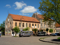 Pre-war German-era houses in Sovetsk/Tilsit
 -
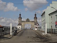 The Queen Louise bridge


References
Notes
- ^ a b c Russian Federal State Statistics Service (2011). Всероссийская перепись населения 2010 года. Том 1 [2010 All-Russian Population Census, vol. 1]. Всероссийская перепись населения 2010 года [2010 All-Russia Population Census] (in Russian). Federal State Statistics Service.
- ^ "26. Численность постоянного населения Российской Федерации по муниципальным образованиям на 1 января 2018 года". Federal State Statistics Service. Retrieved January 23, 2019.
- ^ a b c Resolution #639
- ^ a b c Law #376
- ^ "Об исчислении времени". Официальный интернет-портал правовой информации (in Russian). June 3, 2011. Retrieved January 19, 2019.
- ^ Почта России. Информационно-вычислительный центр ОАСУ РПО. (Russian Post). Поиск объектов почтовой связи (Postal Objects Search) (in Russian)
- ^ a b Federal State Statistics Service (May 21, 2004). Численность населения России, субъектов Российской Федерации в составе федеральных округов, районов, городских поселений, сельских населённых пунктов – районных центров и сельских населённых пунктов с населением 3 тысячи и более человек [Population of Russia, Its Federal Districts, Federal Subjects, Districts, Urban Localities, Rural Localities—Administrative Centers, and Rural Localities with Population of Over 3,000] (XLS). Всероссийская перепись населения 2002 года [All-Russia Population Census of 2002] (in Russian).
- ^ a b Всесоюзная перепись населения 1989 г. Численность наличного населения союзных и автономных республик, автономных областей и округов, краёв, областей, районов, городских поселений и сёл-райцентров [All Union Population Census of 1989: Present Population of Union and Autonomous Republics, Autonomous Oblasts and Okrugs, Krais, Oblasts, Districts, Urban Settlements, and Villages Serving as District Administrative Centers]. Всесоюзная перепись населения 1989 года [All-Union Population Census of 1989] (in Russian). Институт демографии Национального исследовательского университета: Высшая школа экономики [Institute of Demography at the National Research University: Higher School of Economics]. 1989 – via Demoscope Weekly.
- ^ PONARS Eurasia Memo #16. Template:PDFLink
- ^ "Portal Bełchatów". Miasto Bełchatów [Bełchatów town council] belchatow.pl (in Polish). 2010. Archived from the original on June 13, 2011. Retrieved June 22, 2011.
{{cite web}}: Unknown parameter|trans_title=ignored (|trans-title=suggested) (help) - ^ Armin Mueller-Stahl Ehrenbürger seiner Heimatstadt Berliner Zeitung, 8 December 2011 Template:De icon
Sources
- Правительство Калининградской области. Постановление №640 от 30 августа 2011 г. «Об утверждении реестра объектов административно-территориального деления Калининградской области», в ред. Постановления №877 от 21 ноября 2011 г «О внесении изменения в Постановление Правительства Калининградской области от 30 августа 2011 г. №640». Вступил в силу со дня официального опубликования. Опубликован: "Калининградская правда" (вкладыш "Официально"), №170, 15 сентября 2011 г. (Government of Kaliningrad Oblast. Resolution #640 of August 30, 2011 On the Adoption of the Registry of the Objects of the Administrative-Territorial Divisions of Kaliningrad Oblast, as amended by the Resolution #877 of November 21, 2011 On Amending the Resolution of the Government of Kaliningrad Oblast #640 of August 30, 2011. Effective as of the day of the official publication.).
- Калининградская областная Дума. Закон №376 от 31 марта 2004 г. «О наделении муниципального образования "Город Советск" статусом городского округа», в ред. Закона №370 от 1 июля 2009 г «О составе территорий муниципальных образований Калининградской области». Вступил в силу с момента официального опубликования. Опубликован: "Российская газета" ("Запад России"), №88, 27 апреля 2004 г. (Kaliningrad Oblast Duma. Law #376 of March 31, 2004 On Granting the Urban Okrug Status to the Municipal Formation of the "Town of Sovetsk", as amended by the Law #370 of July 1, 2009 On the Composition of the Territories of the Municipal Formations of Kaliningrad Oblast. Effective as of the moment of the official publication.).
- Northern Germany by Karl Baedeker, 14th revised edition, London, 1904, p. 178.
- This article incorporates text from a publication now in the public domain: Chisholm, Hugh, ed. (1911). Encyclopædia Britannica (11th ed.). Cambridge University Press.
{{cite encyclopedia}}: Missing or empty|title=(help)
External links
| International | |
|---|---|
| National | |
| Geographic | |