Surathkal
Surathkal | |
|---|---|
Suburb | |
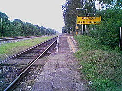
 Surathkal Railway Station | |
| Coordinates: 12°58′10″N 74°46′45″E / 12.96932°N 74.77915°E | |
| Country | |
| State | Karnataka |
| District | Dakshina Kannada |
| Taluk | Mangalore |
| Region | Coastal Karnataka |
| Elevation | 24 m (79 ft) |
| Population | |
• Total | 61,259 |
| Languages | |
| • Official | Tulu, Kannada |
| • Regional | Tulu, Konkani |
| Time zone | UTC+5:30 (IST) |
| PIN | 575014 |
| Telephone code | 0824 |
| Vehicle registration | KA-62 |
Surathkal is a suburb of Mangalore city located on National highway 66 (previously as NH-17) in the Dakshina Kannada district, Karnataka state, India on the shore of Arabian sea. It is a municipality merged with Mangalore City Corporation. It lies between Gurupura ( Phalguni ) and Pavanje ( Nandini ) rivers. It can be considered as the northernmost area of Mangalore City Corporation geographical limits. Surathkal is 8 kilometres north of New Mangalore seaport.
Etymology
According to legend, the name Surathkal is derived from "shiratakal" meaning "headstone" in Tulu. The famous Sadashiva temple on the shores of Arabian Sea (Lakshadweepa samudra ) is said to be built around the linga that a Rakshasa by name Kharasura carried on his head. Another legend is that When Ravana threw in fit of rage the atma shivalinga some of the pieces from shivalinga were fallen at place where Sadashiva temple is at present. Noted historian Padoor Gururaj Bhat is of opinion the temple might have been constructed around 11 C.E. ( 11 A.D ).
Administration
Surathkal was once a Grama panchayat, then town panchayat, municipality now merged with Mangalore City Corporation. Surathkal was once a constituency of Karnataka Legislative assembly. Now it has been renamed as Mangalore North after change in its geographical limits. The Suratkal legislative assembly constituency was part of Udupi Loksabha constituency till 2009.

Education
Surathkal is home to one of India's premier technical institutes - The National Institute of Technology Karnataka (NITK), formerly known as Karnataka Regional Engineering College (KREC). Surathkal also houses Vidyadayanee High School and Govindadasa College run by Hindu Vidyadayanee Sangha, Surathkal. Other notable educational institutes include Sri Mahalingeshwara English Medium school, NITK English Medium School, Holy Family School and Anjuman English Medium High School, Mukka. The Srinivas Institute of Medical Science and Research Centre is located in Mukka, Surathkal.

Travel
Surathkal town can be easily accessed by various bus services from Mangalore City by both city buses and the Mangalore-Udupi Express buses. The nearest airport is Mangalore (Bajpe), 15 kilometres from Surathkal that connects Mangalore with major cities in southern and western India as well as many major cities in the Middle East, with direct flights available to Dubai, Doha, Muscat and Abu Dhabi. Surathkal Railway Station, which is located 3 km away from the National Institute of Technology campus, falls on the famed Konkan railway route on which Rajdhani, Duronto, and other express trains ply regularly from Mangalore to New Delhi. The nearest metropolitan cities, Mumbai and Chennai, are 16 hours away by train. The Mangalore Sea Port is situated 6 km away from this town on the Arabian Sea and primarily used for importing and exporting goods all over the world.
Places Of Interest

National Institute of Technology Karnataka.
NITK Beach.
Surathkal Lighthouse.
Shri Sadashiva Mahaganapati Temple.
Iddya Shri Mahalingeshwara Temple.[3]

Geography
Surathkal is located at 12°58'60 N 74° 46' 60E.[4] The maximum and minimum temperature in a year varies between 37 °C and 21 °C.
Industry
Some of the major industries in and around Surathkal are MRPL, BASF and MCF. The Baikampady Industrial Estate is located at around 6 kilometres from Surathkal and houses many small and medium-sized industries. The raw materials to these industries are imported through the Mangalore port and goods produced here are exported to several places in India and abroad through this port.
See also
External links
References
- ^ "Surathkal Beach". http://www.mapsofindia.com. Retrieved 2011-09-11.
{{cite web}}: External link in|publisher= - ^ "Surathkal Beach – Stretch Your Legs in Surathkal!". http://www.karnataka.com. Retrieved 2012-08-03.
{{cite web}}: External link in|publisher= - ^ "Idya Shree Mahalingeshwara Temple". rcmysore-portal.kar.nic.in. Retrieved 2015-12-19.
- ^ Falling Rain Genomics, Inc - Surathkal

