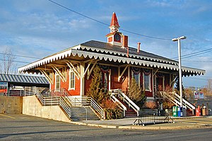
Swampscott station
SWAMPSCOTT | |||||||||||
|---|---|---|---|---|---|---|---|---|---|---|---|
 The 1868-built Swampscott station in 2008 | |||||||||||
| General information | |||||||||||
| Location | 10 Railroad Avenue Swampscott, Massachusetts | ||||||||||
| Owned by | MBTA | ||||||||||
| Line(s) | |||||||||||
| Platforms | 2 side platforms | ||||||||||
| Tracks | 2 | ||||||||||
| Connections | |||||||||||
| Construction | |||||||||||
| Parking | 131 spaces ($4.00 fee) 6 accessible spaces | ||||||||||
| Accessible | Yes | ||||||||||
| Other information | |||||||||||
| Fare zone | 3 | ||||||||||
| History | |||||||||||
| Opened | 1836 (original station) | ||||||||||
| Rebuilt | 1868 (current station) 1997 (renovation) | ||||||||||
| Passengers | |||||||||||
| 2013 | 884 (weekday inbound average)[1] | ||||||||||
| Services | |||||||||||
| |||||||||||
Swampscott Railroad Depot | |||||||||||
| Location | Swampscott, Massachusetts, USA | ||||||||||
| Built | 1868 [3][4] | ||||||||||
| Architect | Cram, George W.; Eastern RR [3][4] | ||||||||||
| Architectural style | Stick/Eastlake | ||||||||||
| NRHP reference No. | 98001106[2] | ||||||||||
| Added to NRHP | August 28, 1998 | ||||||||||
The Swampscott Railroad Depot is a historic passenger rail station in the Stick/Eastlake style, located in the southwest portion of Swampscott, Massachusetts near the Lynn border. Although the depot building is no longer in use, the location is still a stop on the MBTA Commuter Rail Newburyport/Rockport Line. The MBTA's Swampscott station serves as a park-and-ride location for Swampscott and adjoining Marblehead; it is fully handicapped accessible.
History

The existing station building was originally built in 1868 for the Eastern Railroad; it was designed by George W. Cram, a Boston housewright.[3][4][5] The depot was renovated by a group of locals in the 1980s to save it from demolition, but the work was temporary. In 1997, a town committee raised $15,000 to restore the exterior to its original condition, but no interior work was done.[6] On August 28, 1998 it was listed on the National Register of Historic Places.[2]
In 2005, the town attempted to sell the station to a developer, but negotiations stalled in 2006. In 2010, the town again began soliciting proposals for reuse; however, the station has not received proper interior renovations, making reuse difficult.[6] A December 2012 town report advocated for mixed-use development at the station, as well as a pedestrian crossing between the platforms.[7]
Rail trail
In 2004, a town report proposed various transportation improvements, including improving pedestrian and bicycle access to the station from other areas in the town. This included the construction of a mixed-use path on the former Swampscott Branch right-of-way.[8] Service on the Swampscott Branch, which diverged just north of the station, was discontinued in 1959 as the Boston and Maine Railroad shed unprofitable branch lines. The northern section in Marblehead was previously converted to part of the Marblehead Rail Trail, which runs largely along the former Marblehead Branch to South Salem. In 2012, the town drafted an eminent domain claim to obtain part of the right-of-way near the station from National Grid, who was not opposed to the trail but had much stricter requirements to allow conversion.[9]
Bus connections
Four MBTA Bus routes run near the station. Two routes serving Marblehead run on Paradise Road, 1,200 feet (370 m) to the south:
- 441 Marblehead - Wonderland via Central Square, Lynn, Paradise Road & Lynnway
- 442 Marblehead - Downtown Crossing via Paradise Road, Lynnway, & Airport
Two routes serving Salem run on Essex Street, 500 feet (150 m) to the north:
- 455 Salem Depot - Wonderland via Central Square, Lynn
- 459 Salem Depot - Downtown Crossing via Logan Airport & Central Square, Lynn
See also
References
- ^ "Ridership and Service Statistics" (PDF) (14 ed.). Massachusetts Bay Transportation Authority. 2014. Retrieved 2 August 2014.
- ^ a b "National Register Information System". National Register of Historic Places. National Park Service. April 15, 2008.
- ^ a b c "Swampscott Railroad Depot". University of Massachusetts, Dartmouth Library. Archived from the original on 17 March 2012. Retrieved 2 August 2014.
- ^ a b c Massachusetts Department of Conservation and Recreation and Essex National Heritage Commission (May 2005). "Swampscott Reconnaissance Report" (PDF). Essex County Landscape Inventory. Massachusetts Heritage Landscape Inventory Program. Retrieved 2 August 2014.
- ^ Roberts, Oliver Ayer (1895). History of the Military Company of the Massachusetts, now called the Ancient and Honorable Artillery Company of Massachusetts, 1637-1888. A. Mudge and Son. Retrieved 2 August 2014.
- ^ a b Glidden, Debra (28 July 2010). "Tenants show interest in Swampscott depot". The Daily Item. Retrieved 2 August 2014.
- ^ Metropolitan Area Planning Council (30 December 2012). "Swampscott Downtown Vision and Action Plan" (PDF). Town of Swampscott. Retrieved 2 August 2014.
- ^ Metropolitan Area Planning Council (2004). "Swampscott Community Development Plan" (PDF). Town of Swampscott. Retrieved 2 August 2014.
- ^ Moulton, Cyrus (29 February 2012). "Eminent domain sought for section of proposed rail trail". The Daily Item. Retrieved 2 August 2014.


