
Sylvan Pass (Wyoming)
This article needs additional citations for verification. (December 2009) |
| Sylvan Pass | |
|---|---|
 Sylvan Lake on Sylvan Pass | |
| Elevation | 8,524 ft (2,598 m)[1] |
| Location | Park County, Wyoming, United States |
| Range | Absaroka Range |
| Coordinates | 44°27.9′N 110°7.7′W / 44.4650°N 110.1283°W |
Sylvan Pass (el. 8,524 feet (2,598 m)) is a mountain pass located in the Absaroka Range in Yellowstone National Park in Wyoming. The pass provides access to the park from the east entrance.
The pass was named after nearby Sylvan Lake (derived from medieval Latin sylvānus, from Latin Silvānus, god of the woods, from silva, forest), and was formed by frost action breaking the rocks. The park road through the pass was closed during winter but is now open to visitors throughout winter. The road is maintained to allow access via snowmobile, snow coach, and cross-country skiing. In the 2007-08 season it cost the parks service in excess of $200,000 to keep it open and avalanche control measures were put in place.
The Sylvan Pass route is the only way to enter/exit Yellowstone National Park from the East Entrance.
The original road through the pass was designed by Captain Hiram Chittenden of the Army Corps of Engineers.
-
 Sylvan Pass Loop, East Side, 1921
 -
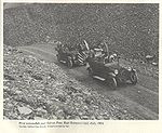 1st automobile over pass, 1914


Notes
Yellowstone National Park – lake and environs | ||
|---|---|---|
Historic structures and other attractions in the Yellowstone Lake, West Thumb, South and East Entrance areas | ||
| Structures and history |  | |
| West Thumb Geyser Basin | ||
| Geography and geology |
| |
This article about a location in Wyoming is a stub. You can help Wikipedia by expanding it. |