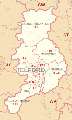
TF postcode area
Appearance
Postcode district boundaries:
KML is from Wikidata
Telford | |
|---|---|
| Coordinates: 52°43′01″N 2°27′40″W / 52.717°N 2.461°W | |
| Country | United Kingdom |
| Postcode area | TF |
| Postcode area name | Telford |
| Post towns | 6 |
| Postcode districts | 13 |
| Postcode sectors | 43 |
| Postcodes (live) | 6,978 |
| Postcodes (total) | 9,230 |
| Statistics as at May 2020[1] | |
The TF postcode area, also known as the Telford postcode area,[2] is a group of thirteen postcode districts in England, within six post towns. These cover north-east Shropshire, including Telford, Broseley, Market Drayton, Much Wenlock, Newport and Shifnal, plus a small part of west Staffordshire.
Coverage
[edit]The approximate coverage of the postcode districts:
| Postcode district | Post town | Coverage | Local authority area(s) |
|---|---|---|---|
| TF1 | TELFORD | Wellington, Leegomery, Hadley, Ketley, Arleston, Hortonwood | Telford & Wrekin |
| TF2 | TELFORD | Oakengates, Priorslee, St. Georges, Donnington, Wrockwardine Wood, Muxton | Telford & Wrekin |
| TF3 | TELFORD | Telford Town Centre and Park, Hollinswood, Randlay, Stirchley, Brookside, Stafford Park | Telford & Wrekin |
| TF4 | TELFORD | Dawley, Malinslee, Lawley, Horsehay | Telford & Wrekin |
| TF5 | TELFORD | Admaston, Bratton, Shawbirch | Telford & Wrekin |
| TF6 | TELFORD | The Wrekin, Wrockwardine, Longden-upon-Tern, High Ercall | Telford & Wrekin |
| TF7 | TELFORD | Madeley, Woodside, Sutton Hill, Halesfield | Telford & Wrekin |
| TF8 | TELFORD | Ironbridge, Coalbrookdale, Coalport, Jackfield | Telford & Wrekin |
| TF9 | MARKET DRAYTON | Market Drayton, Loggerheads, Hodnet, Ternhill | Shropshire, Newcastle-under-Lyme |
| TF10 | NEWPORT | Newport, Lilleshall, Edgmond, Moreton, Great Chatwell, Orslow | Telford & Wrekin, Stafford, South Staffordshire |
| TF11 | SHIFNAL | Shifnal, Tong, Weston-under-Lizard | Shropshire, South Staffordshire |
| TF12 | BROSELEY | Broseley | Shropshire |
| TF13 | MUCH WENLOCK | Much Wenlock | Shropshire |
Map
[edit]KML is from Wikidata

See also
[edit]References
[edit]- ^ "ONS Postcode Directory Version Notes" (ZIP). National Statistics Postcode Products. Office for National Statistics. May 2020. Table 2. Retrieved 19 June 2020. Coordinates from mean of unit postcode points, "Code-Point Open". OS OpenData. Ordnance Survey. February 2012. Retrieved 21 April 2012.
- ^ Royal Mail, Address Management Guide, (2004)

