
Terrigal: Difference between revisions
Tide rolls (talk | contribs) m Reverted edits by 58.96.31.154 to last revision by Recognizance (HG) |
No edit summary |
||
| Line 1: | Line 1: | ||
{{Infobox Australian Place | type = suburb |
{{Infobox Australian Place | type = suburb |
||
| name = Terrigal |
| name = Terrigal (Ben's Home) |
||
| city = [[Central Coast (New South Wales)|Central Coast]] |
| city = [[Central Coast (New South Wales)|Central Coast]] |
||
| state = nsw |
| state = nsw |
||
Revision as of 23:47, 6 May 2009
| Terrigal (Ben's Home) Central Coast, New South Wales | |||||||||||||||
|---|---|---|---|---|---|---|---|---|---|---|---|---|---|---|---|
 The Skillion at sunrise | |||||||||||||||
| Population | 9,746 (2006 census) | ||||||||||||||
| • Density | Lua error: Unable to convert population "9746 (2006 census)" to a number. | ||||||||||||||
| Postcode(s) | 2260 | ||||||||||||||
| Area | 9.1 km2 (3.5 sq mi) | ||||||||||||||
| Location | |||||||||||||||
| LGA(s) | City of Gosford | ||||||||||||||
| Parish | Kincumber | ||||||||||||||
| State electorate(s) | Terrigal | ||||||||||||||
| Federal division(s) | Dobell, Robertson | ||||||||||||||
| |||||||||||||||
Terrigal is a major coastal suburb of the Central Coast region of New South Wales, Australia, located 12 kilometres (7 mi) east of Gosford on the Pacific Ocean. It is part of the City of Gosford local government area.
Terrigal was first settled in 1826 by European Settler John Gray, accompanied by his future wife Amelia Willis, a relatively unknown character in historical readings.[1] The real meaning of the name "Terrigal" remains unclear but may be derived from Aboriginal word "Tarragul", meaning 'a place of little birds'.
The town's long beach is highly popular with tourists. Of geographical significance are the Terrigal lagoons. There are in fact two lagoons at Terrigal, one of which has been filled in to make way for a traffic oval. Just to the east of the town, a local landmark is "The Skillion". This rocky outcrop provides wonderful views of the area. In recent years the Skillion has undergone restabilisation by the local council but has maintained its ability to draw tourists and locals to its peak.

The Skillion is on a preserved area of land known as "The Haven". The Haven is centred by a popular public oval which is home of the "Terrigal Trojans" - a Rugby Union club. The new club house, nicknamed "trojan HQ" was provided by Gosford City Council and is now the home of the Trojans. The Haven also has a popular boat ramp which is partnered by a diving club and a very select few restaurants due to the tight development restrictions on the area.

Throughout recent years, Gosford City Council has spent a large amount of time and $3 million upgrading Terrigal's CBD with a new multi-level car park, esplanade walkway and new stormwater drainage system. On top of the separate upgrade of the Surf Life Saving Club (Terrigal SLSC) and a massive rise in quality of developments in the surrounding bowl of Terrigal - Terrigal's quality of life has risen quite substantially since the 1970s when there was only 1 market, 1 medical centre and orchards in the area. This rise in class from 'small town' to 'tourist destination' and 'investment opportunity' has had both positive and negative effects on the area, with the CBD suddenly getting attention from developers it has never before seen.
Just outside the CBD lies amenities for all walks of life: a recently re-built hotel (2006), a primary school and high school (separate campuses), Catholic School, 'national class' basketball stadium (used for training by Olympic athletes in the 2000 Sydney Olympics), large multi-purpose oval (Duffy's Oval) with 3 fields and year round sporting activities. Not far from the town centre are large shopping centres and freeway (19km) linked to Sydney (south) and Newcastle (north). The town itself is serviced by Terrigal Drive (to the west), Scenic Highway (to the south) and Ocean View Drive to the north.
-
 Beach Front
 -
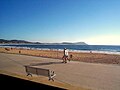 Morning Beach
 -
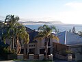 Residential Development
 -
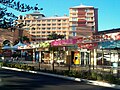 Local Businesses


References
This article needs additional citations for verification. (December 2007) |