
Tortola
 | |
| Geography | |
|---|---|
| Location | Atlantic Ocean |
| Coordinates | 18°25′24″N 64°37′05″W / 18.42333°N 64.61806°W |
| Archipelago | Virgin Islands |
| Area | 55.7 km2 (21.5 sq mi) |
| Length | 19 km (11.8 mi) |
| Width | 15 km (9.3 mi) |
| Highest elevation | 530 m (1740 ft) |
| Administration | |
United Kingdom | |
| Demographics | |
| Population | 23,908 |
| Pop. density | 429.23/km2 (1111.7/sq mi) |
Tortola /tɔːrˈtoʊlə/ is the largest and most populated of the British Virgin Islands, a group of islands that form part of the archipelago of the Virgin Islands.[1] Local tradition recounts that Christopher Columbus named it Tortola, meaning "land of the Turtle Dove". Columbus named the island Santa Ana. The later Dutch settled and called it Ter Tholen, after a coastal island forming part of the west coast of the Netherlands. When the British took over, they altered the name to its present-day Tortola.
History
Europeans began making their mark in Tortola history after 1493, when Christopher Columbus spotted what are now called the British and US Virgin Islands and named them after the 11,000 virgins of the 4th-century martyr St. Ursula. The Spanish made a few attempts to settle the area, but pirates such as Blackbeard and Captain Kidd were the first permanent inhabitants of the island.
In the 17th century, the English, who had successfully usurped control of the area from the Dutch, established a permanent plantation colony on Tortola and the surrounding islands. The sugar cane industry, dependent on the slave labor of Africans transported from the continent, dominated Tortola history over the next 150 years. It diminished in the mid-19th century after the abolition of slavery. A large proportion of the white landowning population left the British Virgin Islands during the economic downturn,[when?] but the political relationship between the island and the British continued and has been maintained.
In the late 1960s, the British businessman Ken Bates attempted to purchase the island on a 199-year lease, but this was blocked after a protest movement led by islander Noel Lloyd forced the local government to drop the plan.[2] Today, a park on Tortola is named after Noel Lloyd and features a statue in his honour.[3]
Geography
Tortola is a mountainous island 13.5 miles (19 km) long and 3 miles (5 km) wide, with an area of 21.5 square miles (55.7 square km). Formed by volcanic activity, its highest peak is Mount Sage at 1750 feet (530 m). Tortola lies near an earthquake fault, and minor earthquakes are common.
Economy and demographics
The population of Tortola is 23,908. The principal settlement is Road Town, the capital of the British Virgin Islands.
Financial services are the main source of income to the island. The popular International Business Companies Act, passed in the early 1980s, led to significant growth in government revenue. BVI residents are amongst the most affluent in the Eastern Caribbean. Numerous residents from other Caribbean islands work there.
Although the British Virgin Islands (BVI) are under the British flag, it uses the U.S. dollar as its official currency due to its proximity to and frequent trade with the US Virgin Islands. The island is home to many offshore companies that do business worldwide.
Attractions
The Northern coast has the best beaches on the island, including Smuggler's Cove, Long Bay, Cane Garden Bay, Brewer's Bay, Josiah's Bay, and Lambert beach. In addition to beaches, there are sailing, surfing, scuba diving, kite boarding, windsurfing, historic sites, hiking, and much more. This is a great site for cruise boats.
Transportation
Tortola can be reached both by sea and by air.
Flights to Tortola arrive at the Terrance B. Lettsome International Airport. The airport is located on Beef Island, just to the East of Tortola, but it is connected by the Queen Elizabeth II Bridge. American Eagle, Cape Air and Air Sunshine provide scheduled service from San Juan. Island Birds Air Charter can connect you from San Juan, St Thomas, Antigua or St Maarten. Tortola also has taxi services. There are many ferry companies providing travellers with the opportunity to arrive by sea. The ferries run between Charlotte Amalie in the center of St. Thomas, and Red Hook in the East End of St. Thomas and St. John, and either Road Town or the West End of Tortola.
Education
The British Virgin Islands operates several government schools. [1]
The following pre-primary schools serve Tortola residents:
- Enid Scatliffe Pre-Primary School
The following elementary schools serve Tortola residents: [2]
- Seventh Day Adventist Primary School
- Enis Adams Primary School
- Joyce Samuel Primary School (formerly Belle Vue Primary School)
- Ivan Dawson Primary School
- Leonora Delville Primary School
- Francis Lettsome Primary School
- Alexandrina Maduro Primary School
- Isabella Morris Primary School
- Althea Scatliffe Primary School
- Ebenezer Thomas Primary School
- Willard Wheatley Primary School
The following High schools serve Tortola Residents:
- Elmore Stout High School (formerly British Virgin Islands High School)
- St George's Secondary School [3]
- Seventh Day Adventist Secondary School
- Cedar International School [4]
Eslyn Henley Richiez Learning Centre serves as Tortola's special needs school.[5]
The H. Lavity Stoutt Community College provides Tortola's Tertiary education
Notable people from Tortola
- The X Factor season 1 winner, Melanie Amaro, lived in Tortola with her grandmother as a child.
- International singing star Iyaz, is from Carrot Bay, Tortola.
- Olympic sprinter J'maal Alexander was born in Tortola.
Images
-
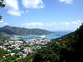 Road Town
 -
 Cane Garden Bay
 -
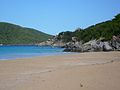 Lambert Beach
 -
 View of the North Coast
 -
 Panoramic View of the Harbour at Road Town
 -
 Panoramic View of Jost Van Dyke looking North West from above Smuggler's cove


See also
References
- ^ "Tortola". British Virgin Islands. Retrieved 14 February 2013.
- ^ Noel Lloyd story published in UK magazine, BVI News, Japhix, 4th November 2011
- ^ The Noel Lloyd Positive Action Park, British Virgin Islands tourism
External links
18°25′24″N 64°37′05″W / 18.42333°N 64.61806°W