
Tsapatagh
40°24′27″N 45°28′26″E / 40.40750°N 45.47389°E
Tsapatagh
Ծափաթաղ | |
|---|---|
Panoramic view of Tsapatagh | |
 Tsapatagh | |
| Coordinates: 40°25′17″N 45°32′00″E / 40.42139°N 45.53333°E | |
| Country | Armenia |
| Marz (Province) | Gegharkunik |
| Population (2001) | |
| • Total | 275 |
| Time zone | UTC+4 ( ) |
Tsapatagh (Armenian: Ծափաթաղ, also Romanized as Tsap’at’agh; formerly, Babajan, Babadzhan, Kzylkend, Kzylk’end, and Kizilkend), is a small resort-village in the Gegharkunik Province of Armenia, on the south-eastern shore of Lake Sevan.[1]
Gallery
- Tufenkian Avan Marak Tsapatagh hotel
-
 Hotel grounds with Lake Sevan in the background
 -
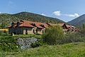 Premises from main road
 -
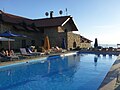 Pool with lake view
 -
 Pool with mountain view
 -


.jpg)
.jpg)
.jpg)
.jpg)
See also
References
- ^ Kiesling, Brady; Kojian, Raffi (2005). Rediscovering Armenia: Guide (2nd ed.). Yerevan: Matit Graphic Design Studio. p. 82. ISBN 99941-0-121-8.
- Tsapatagh at GEOnet Names Server
- Report of the results of the 2001 Armenian Census, Statistical Committee of Armenia
- Kiesling, Brady (June 2000). Rediscovering Armenia: An Archaeological/Touristic Gazetteer and Map Set for the Historical Monuments of Armenia (PDF). Archived (PDF) from the original on 6 November 2021.

This article about a location in Gegharkunik Province, Armenia is a stub. You can help Wikipedia by expanding it. |