
User:Volcycle/Streetcar VA

From 1892 to 1941 streetcars transported people across Northern Virginia and into Washington, D.C. Three companies provided service from downtown Washington, D.C. and Georgetown to Fairfax, Mount Vernon, Bluemont, Great Falls Park and Nauck (in Arlington). In the beginning, the companies were successful. They expanded and merged. But the Great Depression, the rise of the automobile, and the loss of access to the city of Washington forced the companies into bankruptcy. The system was scaled back starting in 1932 and the last streetcar ran in 1941.
History
[edit]Beginning of Operations
[edit]Streetcars began operating in Washington, D.C. in 1862, but it took 30 years for the first northern Virginia line to begin operation. MA&MV authorized to enter DC in 1894.[1]
Merger
[edit]Oct 17, 1910 Washington-Virginia[1]
Banruptcy
[edit]End of the Line
[edit]Washington-Virginia Railway
[edit]The lines of the Washington-Virginia Railway terminated in downtown Washington, D.C., at 12th and D Streets, NW, (within the present Federal Triangle near Pennsylvania Avenue and the Federal Triangle Metrorail Station) after crossing the Potomac River near the site of the present 14th Street bridges over the Long Bridge and, beginning in 1906, the Highway Bridge. The Washington and Old Dominion Railway entered Georgetown after crossing the Potomac River from Rosslyn over the Aqueduct Bridge.
The Washington-Virginia Railway and the Washington and Old Dominion Railway used adjacent terminals in Rosslyn near the present location of the Key Bridge Marriott Hotel. After the Francis Scott Key Bridge replaced the Aqueduct Bridge in 1923, all of the Virginia lines terminated in Rosslyn, but Washington streetcars now crossed the river into Rosslyn where there was a turnaround loop. There, passengers could transfer to the Virginia lines.
Washington, Alexandria, and Mount Vernon Railway
[edit]Washington-Mount Vernon Line
[edit]
Opened in 1892 between Alexandria and Mount Vernon, the Washington, Alexandria, and Mount Vernon Railway was extended in 1896 across the Long Bridge to downtown Washington, D.C., terminating at 12th and D Streets, NW. The streetcars ran in Arlington near and along the present routes of Interstate 395 (I-395) and S. Eads Street, travelling largely on the grade of a towpath on the west side of the defunct Alexandria Canal. Near Arlington's southern border, the railroad and its affiliates constructed an amusement park (Luna Park) and a rail yard containing a car barn and power plant.
After crossing Four Mile Run into Alexandria, the streetcars ran along the present route of Commonwealth Avenue until reaching the city's Old Town area at King Street. The St. Elmo station (located on the present route of Commonwealth Avenue in the Del Ray neighborhood of Alexandria) allowed transfers with the Bluemont branch of the Southern Railway and later, with the Bluemont Division of the Washington and Old Dominion Railway.
At Mount Vernon, when the electric railway began service, the estate's proprietors insisted that only a modest terminal be constructed next to the trolley turnaround. They were afraid that the dignity of the site would be marred by unrestricted commercial development and persuaded financier Jay Gould to purchase and donate thirty-three acres outside the main gate for protection.
By 1906, the railway had transported 1,743,734 passengers along its routes with 92 daily trains. During World War I, the line was extended to Camp Humphreys (now Fort Belvoir).
In 1913, the Washington, Alexandria, and Mount Vernon Railway merged with the Washington, Arlington & Falls Church Railroad to form the Washington-Virginia Railway. The trolley company went into receivership in 1923 when buses became the dominant form of local public transportation.
In 1927, the two railways were separated and sold at auction. The last trolleys of the line ran on January 18, 1932. Later that year the tracks were removed when some of the right-of-way was used for the George Washington Memorial Parkway. The path of the trolley turnaround at Mount Vernon remains as a traffic circle at the south end of the Parkway, while the former rail yard in southern Arlington now serves as a Metrobus yard.
Stations
[edit]The stations of the Washington-Mount Vernon Line of the Washington, Alexandria, and Mount Vernon Railway were (with locations of sites in 2006):

- Camp A. A. Humphreys (now Fort Belvoir)
- Mount Vernon (Fairfax County)
- Deenwood (Fairfax County)
- Miller (Fairfax County)
- Riverside (Fairfax County)
- Hunter (Fairfax County)
- North Mount Vernon (Fairfax County)
- Grassymead (Fairfax County)
- Snowden (Fairfax County)
- Herbert Springs (East Boulevard Drive, Fairfax County)
- Arcturus (East Boulevard Drive, Fairfax County)
- Wellington (East Boulevard Drive, Fairfax County)
- Belmont (Fairfax County)
- Happy Home (Fairfax County)
- Warwick (Fairfax County)
- Dyke (Fairfax County)
- Oaks (Fairfax County)
- New Alexandria (Fairfax County)
- Alexandria (Prince and Royal Streets, Alexandria)
- Rosemont (Commonwealth Ave., Alexandria)
- Braddock (Commonwealth Ave., Alexandria)
- North Braddock (Commonwealth Ave., Alexandria)
- Lloyds (Commonwealth Ave., Alexandria)
- Del Ray (Commonwealth Ave., Alexandria)
- Mount Ida (Commonwealth Ave., Alexandria)
- Saint Asaph (Commonwealth Ave., Alexandria)
- Saint Elmo (Commonwealth Ave. near Ashby St., Alexandria) (crossing of Washington and Old Dominion Railway)
- Four Mile Run (rail yard)(near present intersection of S. Glebe Road (State Route 120) and S. Eads St., Arlington)
- Luna Park (S. Eads St.; present site of Arlington County sewage treatment plant)
- Aurora Hills (S. Eads St., Arlington)
- Virginia Highlands (S. Eads St. and 22nd St. S., Arlington)
- Addison (S. Eads St. and 18th St. S., Arlington)
- Arlington Junction (near 11th St. S. and S. Eads St., Arlington)
- South Washington (near I-395, Arlington)
- Alexander Island (near I-395 between Boundary Channel Drive and George Washington Memorial Parkway, Arlington)
- Washington, D.C. Terminal (formerly at 12th and D Streets, NW; now on 12th Street within the present Federal Triangle near Pennsylvania Avenue and the Federal Triangle Metrorail Station)
Remnants of the Washington-Mount Vernon Line
[edit]- Roads
- Wittington Boulevard, Fairfax County
- East Boulevard Drive, Fairfax County
- Potomac Avenue, Alexandria
- Commonwealth Avenue, Alexandria
- South Eads Street, Arlington
- Metrobus yard
- Former rail yard on east side of S. Eads Street and north side of S. Glebe Road, Arlington
- Traffic circle
- Former trolley turnaround at Mount Vernon estate, Fairfax County
East Arlington branch
[edit]The Washington, Alexandria, and Mount Vernon Railway constructed a branch line that traveled to the Virginia end of the Aqueduct Bridge in Rosslyn from a point named Arlington Junction on the railroad's Alexandria-Mount Vernon line. Along most of its route, the branch travelled along a section of Arlington Ridge Road that is now within Arlington National Cemetery.
Construction of this branch permitted visitors from Washington, D.C., to reach the Cemetery by rail for the first time. However, after leaving the trolley at the Cemetery's Sheridan Gate, the visitors needed to ascend a steep hill to reach most of the Cemetery's well-known features and burial sites.
Stations
[edit]The stations of the East Arlington branch were (with locations of sites in 2006):
- Rosslyn (N. Lynn St., near Key Bridge Marriott Hotel, Arlington)
- Arlington (Sheridan Gate of Arlington National Cemetery)
- Queen City
- Mt. Vernon Junction (near present east crossing of Columbia Pike and Washington Blvd.)
- Relee (I-395 between S. Fern St. and S. Eads St.)
- Arlington Junction (near 11th St. S. and S. Eads St., Arlington)
Washington, Arlington & Falls Church Railroad
[edit]During its forty years of life, this interuban trolley company operated under a variety of names, as it repeatedly expanded, reorganized or contracted (voluntarily or involuntarily).
Washington & Arlington — 1892–1896
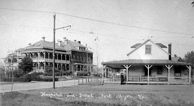
The system started in 1892, under the name Washington & Arlington Railway, as a horsecar line with tracks from Rosslyn up the hill to Ft. Myer. In late 1895 it was electrified.
Washington, Arlington & Falls Church — 1896–1913
In 1896, track was laid from Rosslyn through Clarendon and Ballston to Falls Church and the name was changed to the Washington, Arlington & Falls Church (WA&FC). The track to Ft. Myer was extended through Penrose in 1900 and to Nauck, just north of Four Mile Run, in 1901. That same year saw the opening of about a mile of additional track, extending from East Falls Church to West Falls Church. Work on a far more ambitious extension began at West Falls Church in 1903, and the line eventually reached Fairfax City in 1904.
Washington - Virginia — 1913–1927
In 1913, the WA&FC and Washington, Alexandria & Mt. Vernon were merged to form the Washington - Virginia (W-V) Railway. The company fell upon hard times and in 1924 declared bankruptcy. In 1927, the two companies were split and sold at auction.
Arlington & Fairfax — 1927–1936
The Arlington & Fairfax was organized by local governments to take control of the WA&FC line after the W-V went bankrupt. In 1932, the company lost the right to travel into D.C., and, on January 17, 1932, the last Arlington & Fairfax streetcar departed from 12th & D Streets, NW, abandoning all service in Washington, D.C.
Arlington & Fairfax Auto Railroad — 1936–1939
In 1936, the company was sold to Detroit's Evans Products Company, an innovative railway and automotive industry supplier that had developed the first version of the present hy-rail system called auto-railers, small busses that can run on rails on flanged wheels or on roads with rubber. In 1937, Evans replaced the trolleys with auto-railers. On rail, they went to Rosslyn where they were intended to switch to tires and cross the Key Bridge into Georgetown, eliminating the change in Rosslyn, but Capital Transit prevented that service by objecting that its franchise gave it exclusive service across the bridge. The auto-railers last ran in September 1939.
Nauck line (Fort Myer line)
[edit]The Nauck line (Fort Myer line) ran south from Rosslyn through Fort Myer to an originally undeveloped area in South Arlington near Four Mile Run. After leaving the railroad's Rosslyn terminal near the Aqueduct Bridge, the line travelled south along the present routes of N. Lynn Street and N. Meade Street to reach the Fort. The line then turned to the southwest and entered the Fort near today’s Wright Gate. Within the Fort, trolleys on the line climbed a hill along the present route of McNair Road near the western wall of Arlington National Cemetery to reach a station (Arlington Fort Myer) located within the Fort at the present intersection of McNair Road and Lee Avenue, near the Cemetery's Fort Myer Gate (Chapel Gate).
After disembarking at the Arlington Fort Myer station, visitors could enter the Cemetery at its highest elevation, thus avoiding the ascent required when entering the Cemetery through the Sheridan Gate from the East Arlington branch. After the East Arlington branch discontinued service in 1921, the Nauck line continued to carry visitors to the Cemetery.
The line then continued through Fort Myer, exiting the Fort a short distance north of the Fort's Hatfield Gate. When crossing the present path of Washington Boulevard, the line met at its Hatfield station the South Arlington branch of the railroad's Fairfax line.
After leaving Hatfield, the Nauck line followed the present routes of S. Uhle Street and Walter Reed Drive before travelling downhill on S. Kenmore Street to end at a railway turntable at 24th Road S. and S. Kenmore Street. The line terminated a short distance north of the Cowdon station of the Southern Railway, and later, of the Washington and Old Dominion Railway.
Stations
[edit]The stations of the Nauck line (with locations of sites in 2006) were:
- Rosslyn (N. Lynn St., near Key Bridge Marriott Hotel, Arlington)
- Signal Corps (immediately west of the Netherlands Carillon, Arlington)
- Fort Myer Steps (Jackson Ave. and Stuart Road, Arlington)
- Arlington Fort Myer (McNair Road and Lee Avenue, Arlington)
Arlington Fort Myer trolley station - Hatfield (Washington Blvd. near S. Uhle St., Arlington)
- Hunter (S. Uhle St. near S. Courthouse Road, Arlington)
- Penrose (2312 2nd St. S.)(near 2nd St. S. and S. Uhle St., Arlington)
- Fulcher (S. Barton St. near 3rd. St. S., Arlington)
- Munson (near S. Cleveland St. and 4th St. S., Arlington)
- Bradbury (near S. Edgewood St. and 5th St. S., Arlington)
- Arlington Columbia (S. Walter Reed Dr. and Columbia Pike, Arlington)
- Petty (S. Walter Reed Dr., Arlington)
- Fox (S. Walter Reed Dr. and 16th Rd S.(near S. Glebe Rd.), Arlington
- Fort Berry (S. Kenmore St. and 19th St. S., Arlington)
- Corbett (S. Kenmore St., Arlington)
- Peyton (S. Kenmore St. and 22 St. S., Arlington)
- Nauck/Green Valley (S. Kenmore St. and 24th Road S., Arlington)

Remnants of the Nauck Line
[edit]- Station
- 2312 2nd Street S., Arlington, the former Penrose Station now a private residence
- Roads
- S. Uhle St. between S. Courthouse Rd. and 2nd St. S., Arlington
- Walter Reed Drive between Columbia Pike and 13th St. S., Arlington
- S. Kenmore St., Arlington
Fairfax line
[edit]The Fairfax line travelled from a station in downtown Fairfax City near the Fairfax County Courthouse through Oakton, Vienna, Dunn Loring, Falls Church and Ballston to downtown Washington, D.C., and Rosslyn by way of Clarendon. From Fairfax City to its Vienna station, the line ran a short distance east of Chain Bridge Road and Maple Avenue West (now parts of State Route 123). East of the Vienna station (across the Washington and Old Dominion Railway tracks from Freeman House), the line ran on the present Ninovan Road, Electric Avenue, and Railroad Street. Through Falls Church, the line followed Lincoln Avenue. In Arlington, the line followed the present route of Fairfax Drive (now partially replaced by Interstate 66 (I-66)) to Ballston, where it passed a car barn, rail yard and station that the Washington, Arlington and Falls Church Railroad had built at Lacey (now the intersection of N. Glebe Road and Fairfax Drive). After reaching Clarendon, the line branched.
The North Arlington branch continued to follow the future route of Fairfax Drive (now partially replaced by Clarendon Blvd.),turned north when meeting the Nauck line at N. Lynn Street, joined the East Arlington branch, and terminated in Rosslyn near the Aqueduct Bridge. Beginning in 1906, the North and East Arlington branches and the Nauck line connected at the Rosslyn terminal to the Great Falls and Old Dominion Railroad (later the Washington and Old Dominion Railway), which crossed the Potomac River into Georgetown on the Aqueduct Bridge. In its later years, the North Arlington branch connected in Rosslyn to the streetcars of the Capital Traction and (later) Capital Transit Companies, which then crossed the Potomac on the Francis Scott Key Bridge.
After leaving Clarendon, the South Arlington branch followed Washington Boulevard and Southgate Drive, meeting the Nauck line at Hatfield, the East Arlington branch at Mount Vernon Junction (which received its name because the East Arlington branch was a part of the Washington, Alexandria, and Mount Vernon Railway when the South Arlington branch first reached it), and the Washington-Alexandria-Mount Vernon main line at Arlington Junction. After entering the tracks of the Washington-Alexandria-Mount Vernon line, trolleys of the South Arlington branch (some of which had originated in Fairfax City) crossed the Potomac River on the Long Bridge and, later, on the Highway Bridge to terminate in downtown Washington, D.C. at 12th & D Streets, NW.
I-66 and the Custis Trail now run from Ballston to Lee Highway (U.S. Route 29) in East Falls Church on or near the Fairfax line's right of way along the former route of Fairfax Drive. Metrorail's Orange Line now follows the route of Fairfax line and its North Arlington branch from N. Lynn Street in Rosslyn to Lee Highway in East Falls Church.
Stations
[edit]The stations of the Fairfax line (with locations of sites in 2006) were:

- Fairfax (Fairfax City)
- Cedar Avenue (Cedar Ave., Fairfax City)
- Wiley
- Martinque
- Blake
- Sanger (Blake Lane and Chain Bridge Road, Fairfax County)
- Oakton (Gray St., Fairfax County)
- Edgelea (Edgelea Road and Courthouse Road, Fairfax County)
- Shockey (Hidden Rd., Fairfax County)
- Five Oaks (Sutton Road, Fairfax County)
- Bothwell (Fairfax County)
- Lewis Street (Lewis Street SW, Vienna)
- Library (Library Lane SW, Vienna)
- Court House Road (Courthouse Road SW, Vienna)
- Vienna (Center St. N and Church St. NE) photo
- Park Street (Park Street SE, Vienna)
- Tydidi
- Franklin
- Woodford (Electric Ave. and Woodford Road, Fairfax County))
- East Woodford (Electric Ave., Fairfax County)
- Wedderburn Heights (Electric Ave., Fairfax County)
- Enola (Electric Ave. and Cedar Lane, Fairfax County)
- Dunn Loring (Fairfax County)
- Robey (Fairfax County)
- Burr (Fairfax County)
- Antrum
- West Falls Church (1101 West Broad Street (State Route 7), Falls Church)
- East Falls Church (Lee Highway and I-66, Arlington)
- Ashdale (N. Roosevelt Street and I-66, Arlington)
- Hyson (I-66 near N. Quesada St., Arlington)
- Heights (I-66 between N. Quantico and N. Potomac St., Arlington)
- Highland Park (I-66 near N. Powhattan St., Arlington)
- Upton (N. Ohio St. and I-66, Arlington)
- Kearney (N. Kennesaw St. and I-66, Arlington)
- Torreyson (I-66, Arlington)
- Veitch Summit (N. Jefferson St. and Fairfax Drive, Arlington)
- Mulhall (N. Harrison St. and Fairfax Drive, Arlington)
- Sunnyside (N. Edison St. and I-66, Arlington)
- Burch (I-66, Arlington)
- Waycroft (crossing of the Washington & Old Dominion Railway, Bluemont Division, Thrifton-Bluemont Junction connecting line) (N. Buchanan St. and I-66, Arlington)
- Lacey (N. Glebe Road and Fairfax Drive, Arlington)
- Ballston (N. Stuart St. and Fairfax Drive, Arlington)
- Bolivar (N. Pollard St. and Fairfax Drive, Arlington)
- Belaire (Arlington)
- Clarendon (N. Washington Blvd. and Clarendon Blvd., Arlington)
Remnants of the Fairfax Line
[edit]
- Station
- 2923 Gray Street, Oakton, now a private residence
- Roads
- Ninovan Road SE, Vienna
- Electric Ave., Vienna and Fairfax County
- Railroad St., Fairfax County
- Lincoln Ave., Falls Church
- Fairfax Drive, Arlington
- I-66 between Lee Highway and N. Kennebec St. and between N. Harrison St. and George Mason Drive, Arlington

- Bridge abutments
- Abutments next to the W&OD Trail between Electric Ave. and Ninovan Rd., Vienna, built in July 1904, according to engravings on the side.
- Trails
- Washington & Old Dominion Railroad Trail between Park St. SE and Maple Ave. E, Vienna
- I-66 Custis Trail between Lee Highway and George Mason Drive, Arlington
- Trail through the proposed South Railroad Street Park [1]
North Arlington branch
[edit]Stations
[edit]The stations of the North Arlington branch (with locations of sites in 2006) were:
- Clarendon (Washington Blvd. and Clarendon Blvd., Arlington)
- Courthouse (N. Fairfax Drive and N. Courthouse Road, Arlington)
- Murphy (N. Fairfax Drive between N. Rhodes St. and N. Rolfe St., Arlington)
- Walz (N. Fairfax Drive and N. Queen St., Arlington)
- Rosslyn (N. Lynn St., near Key Bridge Marriott Hotel, Arlington)
Remnants of North Arlington branch
[edit]- Roads
- Clarendon Boulevard, Arlington
- Fairfax Drive, Arlington
South Arlington branch
[edit]Stations
[edit]The stations of the South Arlingon branch (with locations of sites in 2006) were:
- Clarendon (Washington Blvd. and Clarendon Blvd., Arlington)
- Vinson (Washington Blvd. and N. Pershing Drive, Arlington)
- Hatfield (Washington Blvd. near S. Uhle St., Arlington)
- St. John (in Fort Myer, Arlington)
- Syphax (in Fort Myer, Arlington)
- Radio (near Hobson Dr. and Carpenter St., Fort Myer, Arlington)
- Clark (Southgate Road and S. Oak St., Arlington)
- Mt. Vernon Junction (near east crossing of Columbia Pike and Washington Blvd., Arlington)
- Relee (I-395 between S. Eads St. and S. Fern St., Arlington)
- Arlington Junction (near 11th St. S. and S. Eads St., Arlington)
Remnant of South Arlington branch
[edit]- Road
- Washington Boulevard, Arlington
Washington and Old Dominion Railway
[edit]The Washington and Old Dominion Railway Company was chartered by the state of Virginia on January 24, 1900 as the Great Falls and Old Dominion Railroad Company. On January 29, 1903 it was authorized to enter Washington, D.C. on the Aqueduct Bridge.[1]
Stations
[edit]Washington and Old Dominion Railway, Bluemont Division
[edit]Stations
[edit]Notes
[edit]- ^ a b c Tindall, Dr. William (1918). Records of the Columbia Historical Society, Washington, D.C.: Beginning of Street Railways in the National Capital. Charlottesville, VA: Columbia Historical Society. pp. 24–118.
See also
[edit]References
[edit]- Ball, Frank L. (1966). Electric Railways of Arlington. Arlington Historical Magazine.
- Evans, D'Anne A. (1991). The Story of Oakton, Virginia: 1758–1990.
- Harrison, Noel G. (1984). The Advent of the WA&FC: Northern Fairfax County's First Electric Railway. Northern Virginia Heritage.
- Harwood, Herbert Hawley (2000). Rails to the Blue Ridge: The Washington and Old Dominion Railroad, 1847–1968. ISBN 0-615-11453-9.
- Holt, Kathryn (1986). Cherries, Characters, and Characteristics: A History of Cherrydale.
- King, Jr., Leroy O. (1972). 100 Years of Capital Traction. Taylor Publishing. LCC HE4491.W37 K55.
{{cite book}}: CS1 maint: multiple names: authors list (link) - Kohler, Peter C. (2000). Capital Transit: Washington's Street Cars, the Final Era 1933–1962. ISBN 0-9712936-0-0.
- Merriken, John E. (1987). Old Dominion Trolley Too: A History of the Mount Vernon Line. ISBN 0-9600938-2-6. LCC TF725.W34 M47
- Stuntz, Connie Pendleton and Mayo Sturdevant (1987). This Was Vienna, Virginia: Facts and Photos.
- Williams, Ames W (1989). The Washington and Old Dominion Railroad. ISBN 0-926984-00-4.
External links
[edit]- National Capital Trolley Museum
- A memorial site for DC Transit
- Online exhibit of Washington streetcars from the National Museum of American History
- Washington, D.C., Railroad History at the National Railway Historical Society
- Before the Beltway: Streetcar Lines in Northern Virginia, an online exhibit from the Alexandria Public Library
- Penrose Trolleys (Microsoft Word document, *.doc)
- W&OD Railroad: A Photographic History – contains information on the Great Falls electric railway and list of W&OD RR stations
- History of Penrose neighborhood in Arlington with a section on trolleys
- Rossyln Circle History with photo from 1925
Category:Street railways Category:Defunct railroad companies of the United States Category:Electric railways Category:History of Washington, D.C. Category:Transportation in Washington, D.C. Category:Interurbans Category:Streetcars in North America Trolleys Category:Transportation in Arlington County, Virginia Category:Fairfax County, Virginia Category:Alexandria, Virginia Category:Fairfax, Virginia