
Wallpack Center, New Jersey
Wallpack Center, New Jersey | |
|---|---|
 Downtown Wallpack Center | |
 Wallpack Center  Wallpack Center  Wallpack Center | |
| Coordinates: 41°09′32″N 74°52′49″W / 41.15889°N 74.88028°W | |
| Country | |
| State | |
| County | Sussex |
| Township | Walpack |
| Elevation | 138 m (453 ft) |
| Time zone | UTC−05:00 (Eastern (EST)) |
| • Summer (DST) | UTC−04:00 (EDT) |
| ZIP Code | 07881 |
| Area code | 908 |
| GNIS feature ID | 881503[1] |
Wallpack Center (also known as Walpack Center) is an unincorporated community located within Walpack Township, Sussex County, in the U.S. state of New Jersey.[2][3] Wallpack Center is located in the Flat Brook Valley 6.7 miles (10.8 km) west of Branchville. Wallpack Center has a post office with ZIP Code 07881.[4][5] It is now part of the Delaware Water Gap National Recreation Area.[6]
History
[edit]Wallpack Center was established as a farming community in the mid-1800s. The community, which is located in a rural area, functioned as a service center for the surrounding farms. Due to its isolated location, the community only served farmers within its valley, which could not easily go to other communities for services. In the 1900s, the community declined as larger settlements were able to serve the farms in the region.[7]
The community presently includes the post office, a church, a former school used for storage, and six houses.
Historic district
[edit]Wallpack Center Historic District | |
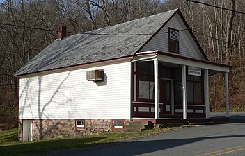
 One-room Schoolhouse | |
| Location | Wallpack Center Road |
|---|---|
| Area | 16 acres (6.5 ha) |
| Architectural style | Late Victorian, Italianate |
| NRHP reference No. | 80000354[8] |
| NJRHP No. | 2645[9] |
| Significant dates | |
| Added to NRHP | July 17, 1980 |
| Designated NJRHP | July 5, 1979 |
The Wallpack Center Historic District is a 16-acre (6.5 ha) historic district encompassing the community. It was added to the National Register of Historic Places on July 17, 1980 for its significance in agriculture, architecture, and exploration/settlement. The district includes 8 contributing buildings.[7]
The one-room schoolhouse was built c. 1856. The Methodist Church was built in 1871 and features Italianate architecture.[7]
-
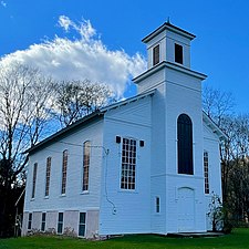 Methodist Church
 -
 General Store and Post Office


References
[edit]- ^ "Wallpack Center". Geographic Names Information System. United States Geological Survey, United States Department of the Interior.
- ^ "N.J.'s 33 best small towns, ranked, for the ultimate fall day trip". September 27, 2019.
- ^ Locality Search, State of New Jersey. Accessed June 9, 2016.
- ^ United States Postal Service (2012). "USPS - Look Up a ZIP Code". Retrieved February 15, 2012.
- ^ "Postmaster Finder - Post Offices by ZIP Code". United States Postal Service. Retrieved July 25, 2013.
- ^ "Delaware Water Gap National Recreation Area: Scenic Drives". National Park Service.
Walpack Center
- ^ a b c Bodle, Wayne K. (April 1977). "National Register of Historic Places Inventory/Nomination: Wallpack Center Historic District". National Park Service. With accompanying 12 photos
- ^ "National Register Information System – (#80000354)". National Register of Historic Places. National Park Service. November 2, 2013.
- ^ "New Jersey and National Registers of Historic Places - Sussex County" (PDF). New Jersey Department of Environmental Protection - Historic Preservation Office. September 28, 2021. p. 9.
External links
[edit]
Municipalities and communities of Sussex County, New Jersey, United States | ||
|---|---|---|
| Boroughs |  | |
| Town | ||
| Townships | ||
| CDPs | ||
| Other communities | ||
| Footnotes | ‡This populated place also has portions in an adjacent county or counties | |
| Landmarks | ||
|---|---|---|
| Districts |
| |
| Places of worship | ||
| Houses | ||
| Buildings | ||
| Sites | ||
| Structures | ||
| International | |
|---|---|
| National | |