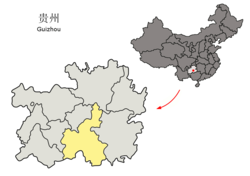
Weng'an County
Appearance
(Redirected from Weng'an)
Weng'an County
瓮安县 Wengan | |
|---|---|
 Weng'an is the northernmost division in this map of Qiannan | |
 Qiannan in Guizhou | |
| Coordinates (Weng'an County government): 27°04′42″N 107°28′15″E / 27.0784°N 107.4709°E | |
| Country | China |
| Province | Guizhou |
| Autonomous prefecture | Qiannan |
| County seat | Yongyang |
| Area | |
| • Total | 1,973.8 km2 (762.1 sq mi) |
| Population (2010) | |
| • Total | 380,458 |
| • Density | 190/km2 (500/sq mi) |
| Time zone | UTC+8 (China Standard) |
| Postal code | 550400 |
| Area code | 0854 |
| Website | www |
Weng'an County (simplified Chinese: 瓮安县; traditional Chinese: 甕安縣; pinyin: Wèng'ān Xiàn) is a county in Qiannan Buyei and Miao Autonomous Prefecture, Guizhou, China.
Weng'an has an area of 1973.8 square kilometers and a population of 460,600 as of 2003.[1]
On June 28, 2008, a riot happened here.
Administrative divisions
[edit]Weng'an County is divided into 2 subdistricts, 10 towns and 1 township:[2]
- subdistricts
- Yongyang 雍阳街道
- Wengshui 瓮水街道
- towns
- Pingdingying 平定营镇
- Houchang 猴场镇
- Zhongping 中坪镇
- Jianzhong 建中镇
- Yonghe 永和镇
- Zhucang 珠藏镇
- Yushan 玉山镇
- Tianwen 天文镇
- Yinzhan 银盏镇
- Jiangjiehe 江界河镇
- township
- Languan 岚关乡
Gallery
[edit]-
Stone tablet in front of Weng'an government building, Guizhou
Climate
[edit]| Climate data for Weng'an, elevation 1,129 m (3,704 ft), (1991–2020 normals, extremes 1981–2010) | |||||||||||||
|---|---|---|---|---|---|---|---|---|---|---|---|---|---|
| Month | Jan | Feb | Mar | Apr | May | Jun | Jul | Aug | Sep | Oct | Nov | Dec | Year |
| Record high °C (°F) | 22.0 (71.6) |
29.3 (84.7) |
30.6 (87.1) |
32.0 (89.6) |
34.4 (93.9) |
31.9 (89.4) |
34.4 (93.9) |
33.2 (91.8) |
33.2 (91.8) |
29.7 (85.5) |
26.1 (79.0) |
22.7 (72.9) |
34.4 (93.9) |
| Mean daily maximum °C (°F) | 6.1 (43.0) |
9.3 (48.7) |
13.9 (57.0) |
19.5 (67.1) |
22.9 (73.2) |
25.1 (77.2) |
27.6 (81.7) |
27.7 (81.9) |
24.3 (75.7) |
18.8 (65.8) |
14.5 (58.1) |
8.7 (47.7) |
18.2 (64.8) |
| Daily mean °C (°F) | 3.0 (37.4) |
5.6 (42.1) |
9.5 (49.1) |
14.7 (58.5) |
18.4 (65.1) |
21.2 (70.2) |
23.2 (73.8) |
22.7 (72.9) |
19.6 (67.3) |
14.8 (58.6) |
10.4 (50.7) |
5.1 (41.2) |
14.0 (57.2) |
| Mean daily minimum °C (°F) | 1.1 (34.0) |
3.1 (37.6) |
6.7 (44.1) |
11.6 (52.9) |
15.3 (59.5) |
18.5 (65.3) |
20.1 (68.2) |
19.4 (66.9) |
16.4 (61.5) |
12.2 (54.0) |
7.6 (45.7) |
2.8 (37.0) |
11.2 (52.2) |
| Record low °C (°F) | −7.1 (19.2) |
−7.1 (19.2) |
−5.1 (22.8) |
1.1 (34.0) |
4.5 (40.1) |
11.6 (52.9) |
11.2 (52.2) |
11.8 (53.2) |
6.5 (43.7) |
2.1 (35.8) |
−4.4 (24.1) |
−7.3 (18.9) |
−7.3 (18.9) |
| Average precipitation mm (inches) | 32.0 (1.26) |
31.9 (1.26) |
53.7 (2.11) |
102.2 (4.02) |
157.6 (6.20) |
188.2 (7.41) |
190.4 (7.50) |
125.0 (4.92) |
90.1 (3.55) |
92.5 (3.64) |
45.4 (1.79) |
27.5 (1.08) |
1,136.5 (44.74) |
| Average precipitation days (≥ 0.1 mm) | 16.9 | 14.9 | 18.7 | 17.7 | 17.9 | 17.8 | 14.4 | 13.5 | 12.5 | 16.5 | 12.9 | 13.8 | 187.5 |
| Average snowy days | 5.9 | 3.6 | 0.6 | 0 | 0 | 0 | 0 | 0 | 0 | 0 | 0.1 | 2.1 | 12.3 |
| Average relative humidity (%) | 84 | 82 | 82 | 81 | 81 | 83 | 81 | 81 | 81 | 84 | 83 | 82 | 82 |
| Mean monthly sunshine hours | 30.7 | 45.2 | 63.5 | 87.8 | 102.4 | 88.1 | 150.1 | 161.6 | 115.9 | 74.0 | 70.7 | 49.8 | 1,039.8 |
| Percent possible sunshine | 9 | 14 | 17 | 23 | 24 | 21 | 36 | 40 | 32 | 21 | 22 | 15 | 23 |
| Source: China Meteorological Administration[3][4] | |||||||||||||
References
[edit]- ^ "Profile of Weng'an County" (in Chinese). Retrieved 2008-07-03.
- ^ 2023年统计用区划代码和城乡划分代码:瓮安县 (in Simplified Chinese). National Bureau of Statistics of China.
- ^ 中国气象数据网 – WeatherBk Data (in Simplified Chinese). China Meteorological Administration. Retrieved 28 April 2023.
- ^ 中国气象数据网 (in Simplified Chinese). China Meteorological Administration. Retrieved 28 April 2023.
External links
[edit]Wikimedia Commons has media related to Weng'an County.

