
Wikipedia:Graphics Lab/Map workshop/Archive/May 2011
Stale[edit]
Trinidad area code map[edit]
-
 a not-bad map of Trinidad
 -
an area-code map of Trinidad, drawn in crayons

Article(s): [[Area code 868
Request: This crayon-made version is an embarrassment. Can someone make a better one, please? DS (talk) 23:41, 26 January 2011 (UTC)
Graphist opinion(s): We'd need a source for the area code boundaries other than the crayon map to base a new one on. I did a very quick look and didn't see one. Kmusser (talk) 13:39, 29 January 2011 (UTC)
- Hm. If we don't have a source for the area code boundaries, should the image be deleted? DS (talk) 22:34, 27 February 2011 (UTC)
http://maps.google.pt/maps?f=q&source=s_q&hl=pt-PT&q=10.691803,-61.222503&aq=&sll=10.691803,-61.222503&sspn=2.628472,3.532104&ie=UTF8&hnear=Trindade+e+Tobago&lci=org.wikipedia.pt&rq=1&split=0&ll=11.636096,-60.985107&spn=2.619948,3.532104&z=8&iwloc=ltrends — Preceding unsigned comment added by Medeiros26 (talk • contribs) 20:43, 5 March 2011 (UTC)
-

-
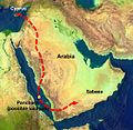 Myrrha's flight route from her father.


Article(s): Myrrha
Request: I would really like these two maps to be in the same "design" (an SVG map could be cool, but I don't know if that's possible for this sort of map). If you could make two maps that show the routes plus borders of the countries in the early Ancient Greek world it would really be great. Please note that the location of the island Panchaea is up to you - it's a fictional island - but it is likely that those who told the myth of Myrrha imagined it to be around the place where I've put it. Please contact me, regards Mottenen (talk) 19:57, 6 March 2011 (UTC)
Graphist opinion(s):
Baltic Pipeline System-II[edit]
-
Description of image
-
2nd image (If there is one)
-
Don't request too many at once, though
Article(s): Baltic Pipeline System-II
Request: This article needs a proper map. Right now it uses scheme which bases on the template of railway line, and the pinpoint map showing pumping stations; however, these maps are ugly and not very user-friendly. The route map of the pipeline is shown at http://www.transneft.ru/objectdata/WebPageImpl/3658/74.gif. It could be also option to show Baltic Pipeline System and Baltic Pipeline System-II at the same map. Beagel (talk) 09:46, 8 March 2011 (UTC)
Graphist opinion(s):
Baltic Pipeline System[edit]
-
Description of image
-
2nd image (If there is one)
-
Don't request too many at once, though
Article(s): Baltic Pipeline System
Request: This article uses general map with a number of oil and gas pipelines in Russia. However, a pipeline specific map could be more apropriate. The specific map is at http://www.ecifpa.ru/content.asp?pn=318&lang=en It could be also option to show Baltic Pipeline System and Baltic Pipeline System-II at the same map. Beagel (talk) 09:55, 8 March 2011 (UTC)
Graphist opinion(s):
French Departments[edit]
General question - would it be possible to produce maps of all the French Departments for use in articles relating to France, in a similar way to those of the British counties. Compare the infobox in Lympne Airport to that of Saint-Inglevert Airfield and you will see why this would be desirable. Maybe Pas-de-Calais could be created first as an exercise to see whether this would be possible. Mjroots (talk) 07:11, 19 March 2011 (UTC)
- Looks like they are already in progress by the French wikipedia, see Location maps of France, if you want a specific one you may try asking at the French version of this page. Kmusser (talk) 14:18, 19 March 2011 (UTC)
- My French isn't that good! I tried replacing the pushpin map France with Pas-de-Calais but that only produced an error on preview. Mjroots (talk) 10:21, 20 March 2011 (UTC)
- No one has made a Pas-de-Calais location template yet, and ideally the Pas-de-Calais location map still needs to be SVGified, it looks like they are working on them on the French wikipedia, but not all the departments are done yet. I don't understand the template syntax well enough to write one, but here is one for a different Department. Kmusser (talk) 01:15, 21 March 2011 (UTC)
- My French isn't that good! I tried replacing the pushpin map France with Pas-de-Calais but that only produced an error on preview. Mjroots (talk) 10:21, 20 March 2011 (UTC)
Byzantine-Bulgarian wars 893-927[edit]
-
 Base map

Article(s): Byzantine-Bulgarian Wars, Battle of Boulgarophygon, Battle of Achelous (917), Simeon I of Bulgaria, Treaty of 927 (when created)
Request: I have created a very rough and ugly map of how I approximately imagine it. The sources are two maps of Atlas of History [1] and [2] (the second is not very clear). The hachures to the west notify the Principality of Serbia which was annexed between 924 and 931; those to the south mark the territorial extension at Byzantine expense in 904 therefore the first black line is the border when Simeon I became ruler in 893; the second one - in 904. The dotted line marks the temporary military border between 913 and 927; while the red line is the border as it was agreed by the peace treaty in 927 and which stayed unchanged until 971.
I am not sure I have cropped the very best base map; you can use another one if it would be better. In my ugly map, I have put the main cities which should be placed in the map. I think that such a map will be useful to illustrate the border changes of that important episode of the Byzantine-Bulgarian war. Regards, Gligan (talk) 16:51, 23 March 2011 (UTC)
Malaysian map[edit]
-
 Current map
 -
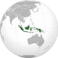 Slightly better, but not perfect positioning
.svg)
.svg)
Article(s): Malaysia
Request: Is it possible to make Malaysia located more centrally? I've tried contacting a couple of people who appear to have made these sorts of maps before, but haven't got a response. Something rotated slightly more towards the west than the Indonesian one would be perfect. Chipmunkdavis (talk) 14:48, 24 March 2011 (UTC)
Graphist opinion:
Map remake[edit]
-
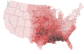 Tornado watch frequency map
 -
 Severe thunderstorm watch frequency map


Article(s): Tornado watch for the former, Severe thunderstorm watch for the latter
Request: I didn't notice this at the time these files were made (refer to this previous GL request), but the county borders are way off from what they are supposed to be. Compare for example the Kansas and Oklahoma county borders (especially Osage County, Oklahoma and Wabaunsee County, Kansas. The borders seem to be generalized, making the counties misshapen. If possible, could someone please remake these maps with better county borders? I will supply the data used to create the maps in .csv format the same as I did with the previous request, so any graphists who take this request will need to email me so I can reply with the data. Thanks in advance, and there will be a barnstar awaiting a job well done. Ks0stm (T•C•G) 03:00, 25 March 2011 (UTC)
Graphist opinion(s):
Blank SVG Robinson Projection Map with Second-Level Subdivisions[edit]
-
 1. The base image
 -
 2. A map with the right projection (Robinson), but wrong format (.png) and lacking subdivisions for many countries
 -
 3. A map with the wrong projection (Lambert cylindrical), and too large for most computers to open, but right format (.svg) and has all the necessary subdivisions.
 -
 4. A map with the wrong projection (Lambert cylindrical), wrong format (.png), is missing Alaska and the Pacific, and has subdivisions beyond the second level. This is the map currently used in the articles in question.


Article(s): Political division, Administrative division
Request: Blank maps with second-level divisions are useful beyond the two articles in question, but the Lambert cylindrical projection creates an unpleasant shape distortion at the poles (e.g. the third and fourth images). The Robinson projection is superior in this aspect (e.g. the first and second images). If it becomes desirable to create maps with third-level, fourth-level, etc. divisions (as in the fourth image), I feel that they should be created and maintained separately, so that all are available, rather than just the most extensive level of subdivisions. Subdivisions of a country should be grouped so that an entire country can be easily filled. If individual subdivisions need to be filled, then the user can ungroup them. The same goes for smaller subdivisions. There should be some way to visually distinguish second-level subdivisions from first-level subdivisions (unlike the third image). I prefer that subdivisions have thinner outlines than the country they pertain to (e.g. the second image) rather than giving them different outline colors (e.g. the fourth image), but the community may disagree with me on this point. Note that there is a python script available for manipulating the first image that may be useful for this project. Just to be clear, I want the new map to be based on the first image; the other three are only provided for reference and/or comparison. Ninjatacoshell (talk) 16:10, 25 March 2011 (UTC)
Graphist opinion(s):
![]() Request taken by Ninjatacoshell.
Request taken by Ninjatacoshell.
![]() Done
Done
The Albanian Muslim's flag[edit]
Request moved to Illustration workshop. See here Fallschirmjäger ✉ 15:21, 28 March 2011 (UTC)
North American Area Code Maps[edit]
Article(s): List of NANP area codes
Request: There are many North American area code pages that do not have any maps, and many of the ones that do have maps do not conform to the WikiProject Maps Best Practices. The whole section could use some map standardization.
I just started on it myself - Area codes 601 and 769, but need a lot of help. -Dolenath (talk) 20:51, 28 March 2011 (UTC)
Graphist opinion(s):
Resolved[edit]
Situation map, MS Express Samina, Ferry Disaster off Paros[edit]
This request was made on the helpdesk [3] - I thought this the best place, so copied it here. Chzz ► 07:16, 9 April 2011 (UTC)
Article(s): MS Express Samina
Request: I want a free version of this situation map: http://www.greekislandhopping.com/Updates/updateAssets/u_exsammap.jpg ( source: http://www.greekislandhopping.com/Updates/updatepages/u_disaster.html ) to use in the article MS Express Samina. Could someone create one plz? Thanks! SpeakFree (talk) 23:56, 8 April 2011 (UTC)
Graphist opinion: Here's what I did. I know it's far from perfect, everyone's welcomed to change it.--Sisyphos23 (talk) 19:44, 12 April 2011 (UTC)

Locator map of Azerbaijan[edit]
-
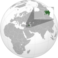 locator map of Azerbaijan
.png)
Article(s): Azerbaijan
Request: You see what we've been trying to do here, but it seems we aren't quite the svg experts. The country should also show up in green in the large map, and it does when I open the svg file on its own, but for some reason this doesn't work in the thumbnail. If somebody can fix this, please just overwrite the current file with your version. Perhaps you can also do something to make the inset work better in thumbnail size (perhaps increase frame thickness, or change the shades of grey and white in the inset?) dab (𒁳) 13:40, 16 April 2011 (UTC)
Graphist opinion(s):
![]() Done: Fixed the green color problem.--Sisyphos23 (talk) 23:51, 20 April 2011 (UTC)
Done: Fixed the green color problem.--Sisyphos23 (talk) 23:51, 20 April 2011 (UTC)
Ages of consent in North America[edit]
Article(s): Ages of consent in North America
Request: A map of North America showing the ages of consent for each country. There's a map there, but it is seriously flawed, see the talk page of the article: Talk:Ages_of_consent_in_North_America#New_map. The sources are in the article, each country's age of consent is presented there, with sources, for Mexico there is a table in its section. 188.25.173.128 (talk) 20:15, 8 March 2011 (UTC)
Graphist opinion(s):
![]() Request taken by magnoliasouth. I can give it a go. The problem is the size of the graphic or legend. For a map of North America to include divisions of US states, it is absolutely too small and would be confusing no matter what colors you use. I'll try and if it doesn't work, I'll remove the taken tag. MagnoliaSouth (talk) 15:43, 24 April 2011 (UTC)
Request taken by magnoliasouth. I can give it a go. The problem is the size of the graphic or legend. For a map of North America to include divisions of US states, it is absolutely too small and would be confusing no matter what colors you use. I'll try and if it doesn't work, I'll remove the taken tag. MagnoliaSouth (talk) 15:43, 24 April 2011 (UTC)
![]() Done I've uploaded the file here. I tried editing the page itself and while I can edit it, I cannot edit the picture box for some reason. It says it's locked but I'm an established user, or so I thought. Really, I did think I was able to do so. Someone else will have to change the image. I'm going to be really upset if I completely wasted my time doing this. MagnoliaSouth (talk) 21:11, 24 April 2011 (UTC)
Done I've uploaded the file here. I tried editing the page itself and while I can edit it, I cannot edit the picture box for some reason. It says it's locked but I'm an established user, or so I thought. Really, I did think I was able to do so. Someone else will have to change the image. I'm going to be really upset if I completely wasted my time doing this. MagnoliaSouth (talk) 21:11, 24 April 2011 (UTC)
Label Errors in Caribbean Map[edit]
-
 Map of the Caribbean with various label problems
 -
 New map


Articles: Caribbean, Caribbean Sea, Antilles, Battle of the Caribbean, Central banks and currencies of the Caribbean, List of islands in the Caribbean, many others
Request: If you look closely at this map, you will see that many of the place labels have been partially or completely cut off. The problem is most pronounced with Haiti---the country is labeled "ITI", Cap-Haitien has lost its first word, and the label for Port-au-Prince is missing completely. Havana, Cuba has also lost its label, and there are probably other errors I haven't noticed. Apparently any text overlapping the sea was cut off when the image was created. These errors need to be fixed. 69.140.242.23 (talk) 22:23, 25 March 2011 (UTC)
Caracas, Venezuela is also missing its label. It may not matter that some capital cities are unlabeled, since this map seems to be intended mainly to show the countries and islands of the Caribbean, but the labels that are only half missing are actually conveying false information. 69.140.242.23 (talk) 22:30, 25 March 2011 (UTC)
Graphist opinion(s): ![]() Request taken by Kmusser., I'll do a new one rather than try to fix that one, it may take me awhile. In the meantime I'd recommend using the original that one was made from, File:Central america (cia).png, instead.
Request taken by Kmusser., I'll do a new one rather than try to fix that one, it may take me awhile. In the meantime I'd recommend using the original that one was made from, File:Central america (cia).png, instead.
- Done, check out the new map and let me know if anything else is needed. Kmusser (talk) 01:48, 10 April 2011 (UTC)
- non-proposer request/comment nice, to me it looks good! would it be possible to get the c-cedille in place at Curaçao? L.tak (talk) 23:44, 10 April 2011 (UTC)
West Bengal legislative assembly election, 2011[edit]
-
 Schedule of polls

Article(s): West Bengal legislative assembly election, 2011
Request: The map above is ready to go but can someone add the districts from this map/file? Thanks Lihaas (talk) 15:39, 24 April 2011 (UTC)
Graphist opinion(s):
![]() Done--Sisyphos23 (talk) 17:11, 24 April 2011 (UTC)
Done--Sisyphos23 (talk) 17:11, 24 April 2011 (UTC)
- I've forgot phase 1 district names indeed, I've added them now and changed the color. Mark {{resolved}} if you're happy with the result.--Sisyphos23 (talk) 19:10, 9 May 2011 (UTC)
Map of WB distt.[edit]
-
West Bengal Election 2011
-

.svg)
Article(s): WB2011
Request: I request the map in only light gray color. Please add a key with two colours One #FF0000 - for Left Front and the other #66FF00 - for United Progressive Alliance. The new image is requested to be named West Bengal general elections, 2011 - Results (by district).svg. GaneshBhakt (talk) 05:50, 1 May 2011 (UTC)
Graphist opinion(s):
![]() Done--Sisyphos23 (talk) 20:16, 3 May 2011 (UTC)
Done--Sisyphos23 (talk) 20:16, 3 May 2011 (UTC)
- If that's what you ask, please mark as "resolved", and add a more detailed description of the file in the commons :)--Sisyphos23 (talk) 08:28, 4 May 2011 (UTC)
- I am also looking of that. In future I am updates that. Thanks. --- Jayanta Nath (Talk|Contrb) 08:39, 4 May 2011 (UTC)
West Bengal general elections, 2011 - Results (by district)[edit]
-
 West Bengal general elections, 2011 - Results (by district)
.png)
![[1]](http://haripetrov.com/chitanka/site/content/pic/00/142/atlas-istoria-11klas-11.jpg)
.png)
Article(s): WB2011
Request: Updated result map, tirelessly worked upon, based on this source. In all the districts Didi has won half the seats, so the map had to be coloured completely green.
Request this image to be converted into .svg format and uploaded as a new verion to File:West Bengal general elections, 2011 - Results (by district).svg. GaneshBhakt (talk) 15:41, 13 May 2011 (UTC)
- As per result it is not all green, means in all West Bengal TMC not won all constituency. So I am working in File:West Bengal state assembly election, 2011 - Results.svg. So dear Sisyphos23 please dont west your valuable time on that.- Jayanta Nath (Talk|Contrb) 18:29, 13 May 2011 (UTC)
- See this http://www.ndtv.com/elections/assembly-data.php?page=WB-Map final result map with colour.--- Jayanta Nath (Talk|Contrb) 18:40, 13 May 2011 (UTC)
- Ok it's up to Jayanta Nath now ;)! I've colored the map nevertheless.--Sisyphos23 (talk) 18:42, 13 May 2011 (UTC)