Fintown
Fintown
Baile na Finne | |
|---|---|
Village | |
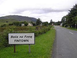
 Signage at the entrance to the village | |
| Coordinates: 54°52′14″N 8°06′48″W / 54.8706°N 8.1133°W | |
| Country | Ireland |
| Province | Ulster |
| County | County Donegal |
| Government | |
| • Dáil Éireann | Donegal |
| Elevation | 169 m (554 ft) |
| Baile na Finne is the only official name. The English name Fintown has no official status. | |
Fintown (officially known by its Irish name, Baile na Finne[1]) is a small village and townland on the banks of Lough Finn in County Donegal, Ireland. It is within the Gaeltacht, an Irish-speaking area, in the west of the county. Overlooked by Aghla (589m, 1961 ft) and Screig Mountains, its main attraction is an Mhuc Dhubh, the Fintown Railway (Donegal's only operational narrow gauge railway), which runs along the length of Lough Finn.[2] The village was named after a mythological woman, Fionngheal, who drowned in the lake after attempting to save her wounded brother Feargamhain.[3]
Demographics
[edit]As of the 2016 census, there were 88 people in the townland of Fintown,[4] and 280 people in the electoral division of Baile na Finne (the surrounding hinterland).[5] Of these, 59% were Irish speakers.[citation needed]
Gallery
[edit]-
The Railway Inn
-
The Fintown Railway at Fintown station
See also
[edit]References
[edit]- ^ "Irish Placenames Order 2004" (PDF). commissioner.ie.
- ^ "Fintown Railway website". antraen.com.
- ^ "Fintown". County Donegal on the Net. Archived from the original on 28 July 2012. Retrieved 23 March 2013.
- ^ Fintown, Donegal. Census 2016 (Report). Central Statistics Office.
TD_ID [..] 51248 [..] FINTOWN [..] DONEGAL [..] 38D27FA3-5006-4E59-B01C-44DDB425E3B6 [..] TOTAL2016 / 88 [..] TOTAL2011 / 101
- ^ "Sapmap Area - Electoral Division - Baile Na Finne". Census 2016. Central Statistics Office. April 2016. Retrieved 31 October 2021.


