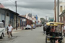
Ciego de Ávila
Ciego de Ávila | |
|---|---|
 Ciego de Ávila municipality (red) within Ciego de Ávila Province (yellow) and Cuba | |
| Country | |
| Province | Ciego de Ávila |
| Established | 1840[1] |
| Area | |
| • Municipality | 445 km2 (172 sq mi) |
| Elevation | 55 m (180 ft) |
| Population (2010)[3] | |
| • Municipality | 143,449 |
| • Density | 320/km2 (830/sq mi) |
| • Urban | 125,609 |
| Demonym | Avileño/a |
| Time zone | UTC-5 (EST) |
| Postal code | 65200 |
| Area code | +53 43 |
| Highways | Carretera Central |
Ciego de Ávila is a city in the central part of Cuba and the capital of Ciego de Ávila Province. The city has a population of about 86,100.
Overview

Ciego de Ávila lies on the Carretera Central highway and on a major railroad. Its port, Júcaro, lies 24 km (15 mi) south-southwest on the coast of the Gulf of Ana Maria in the Caribbean Sea. The city is located about 460 km (290 mi) east of Havana and 110 km (68 mi) west of the city of Camagüey. It was part of the Camagüey Province until 1976, when Fidel Castro's government made Ciego de Ávila the capital of the newly created Ciego de Ávila Province.
By 1945, the municipality was divided into the barrios of Angel Castillo, Ceballos, Guanales, Jagüeyal, Jicotea, José Miguel Gómez, Júcaro, La Ceiba, Majagua, Norte, San Nicolás and Sur. After the new political and administrative division of Cuba in 1976, it was divided into four municipalities (Majagua, Ciego de Ávila, Baragua and Venezuela).[1]
History
The city of Ciego de Ávila was founded by 1840, having at the time 263 inhabitants. In 1877, its municipal government was created and the city became independent of the city of Morón. Ciego de Ávila gained importance when the Spanish army built a fortified military line, known as Trocha de Jucaro a Morón, to impede the pass of insurrectionist forces to the western part of the island during the 1st War of Independence (1868-1878). This "trocha", which made this region famous, was thought to be strong enough to stop the Cuban forces, but was not able to stop the pass of General Máximo Gómez and several hundred of men. Many of the old Spanish colonial buildings in Ciego de Ávila were built by Angela Hernández Viuda de Jiménez, a rich socialite who battled to create a cultural mecca in her home town. She is sometimes credited to be the founder of the city.
Demographics
In 2004, the municipality of Ciego de Ávila had a population of 135,736.[3] With a total area of 445 km2 (172 sq mi),[2] it has a population density of 305.0/km2 (790/sq mi).
Media
Its present radio station, Radio Surco (previously Radio Cuba) was founded October 10, 1952.
Attractions
- Parque Martí is the largest park in the city of Ciego de Ávila.
- Teatro Principal is a 500-seat theatre located just a few blocks from Parque Martí.
- University of Ciego de Ávila (Universidad de Ciego de Ávila, UNICA) is the province's secondary education institution.
- IPVCE Ignacio Agramonte Instituto Pre-Universitario Vocacional de Ciencias Exactas(10 a 12 grado) con emphasis en las ciencias basicas: Fisica, Quimica, Matematica, Biologia y Electronica. Se encuentra en la carretera a Ceballos.
Notable residents
- Tony Pérez, Baseball Player
See also
References
- ^ a b Guije.com. "Ciego de Ávila". Retrieved 2007-10-06. Template:Es icon
- ^ a b Statoids (2003). "Municipios of Cuba". Retrieved 2007-10-06.
{{cite web}}: Unknown parameter|month=ignored (help) - ^ a b Atenas.cu (2004). "2004 Population trends, by Province and Municipality". Archived from the original on 2007-09-27. Retrieved 2007-10-06. Template:Es icon
External links
 Media related to Ciego de Ávila at Wikimedia Commons
- Ciego de Ávila
