
Grong
Grong Municipality
Grong kommune | |
|---|---|
 Grong in early August 2007 | |
 Flag | |
 Trøndelag within Norway | |
 Grong within Trøndelag | |
| Coordinates: 64°31′53″N 12°37′12″E / 64.53139°N 12.62000°E | |
| Country | Norway |
| County | Trøndelag |
| District | Namdalen |
| Established | 1 Jan 1838 |
| • Created as | Formannskapsdistrikt |
| Administrative centre | Medjå |
| Government | |
| • Mayor (2023) | Ann Jeanett Klinkenberg (Ap) |
| Area | |
| • Total | 1,136.17 km2 (438.68 sq mi) |
| • Land | 1,095.32 km2 (422.91 sq mi) |
| • Water | 40.84 km2 (15.77 sq mi) 3.6% |
| • Rank | #96 in Norway |
| Population (2023) | |
| • Total | 2,296 |
| • Rank | #262 in Norway |
| • Density | 2.1/km2 (5/sq mi) |
| • Change (10 years) | |
| Demonym | Grongning[1] |
| Official language | |
| • Norwegian form | Neutral |
| Time zone | UTC+01:00 (CET) |
| • Summer (DST) | UTC+02:00 (CEST) |
| ISO 3166 code | NO-5045[3] |
| Website | Official website |

ⓘ (Southern Sami: Kråangke) is a municipality in Trøndelag county, Norway. It is part of the Namdalen region. The administrative centre of the municipality is the village of Medjå (sometimes called Grong also). Other villages in the municipality include Bergsmoen, Formofoss, Gartland, and Harran.
The 1,136-square-kilometre (439 sq mi) municipality is the 96th largest by area out of the 356 municipalities in Norway. Grong is the 262nd most populous municipality in Norway with a population of 2,296. The municipality's population density is 2.1 inhabitants per square kilometre (5.4/sq mi) and its population has decreased by 6.9% over the previous 10-year period.[4][5]
General information[edit]
Grong was established as a municipality on 1 January 1838 (see formannskapsdistrikt law). On 1 January 1901, the northwestern district of Grong (population: 1,046) was separated to form the new municipality of Høylandet. On 1 January 1923, the large municipality of Grong was divided into four smaller municipalities: Grong (population: 1,272) in the southwest, Harran (population: 630) in the centre, Røyrvik (population: 392) in the northeast, and Namsskogan (population: 469) in the northwest.
During the 1960s, there were many municipal mergers across Norway due to the work of the Schei Committee. On 1 January 1964, the neighboring municipalities of Harran (population: 1,085) and Grong (population: 1,962) were merged (back together) to form a new municipality called Grong.[6]
On 1 January 2018, the municipality switched from the old Nord-Trøndelag county to the new Trøndelag county.
Name[edit]
The municipality (originally the parish) is named after the old Grong farm (Old Norse: Granungar) since the first Grong Church was built there. The first element is grǫn which means "spruce". The last element is the plural form of the suffix -ungr which is a common suffix for place names in Norway.[7]
Coat of arms[edit]
The coat of arms was granted on 6 February 1987. The official blazon is "Argent, three triangles vert in pale" (Norwegian: I sølv tre grønne trekanter, 1-1-1). This means the arms have a field (background) that has a tincture of argent which means it is commonly colored white, but if it is made out of metal, then silver is used. The charge is three green triangles lined up vertically. The green triangles symbolize spruce trees (Norwegian: gran) which dominate almost 40% of the municipal areas. This makes them canting arms since the name of the municipality is supposedly derived from Granungar which means spruce. The number three symbolizes the three main villages in the municipality: Harran, Bergsmoen, and Medjå. The arms were designed by Einar H. Skjervold.[8][9][10]
Churches[edit]
The Church of Norway has two parishes (sokn) within the municipality of Grong. It is part of the Namdal prosti (deanery) in the Diocese of Nidaros.
| Parish (sokn) | Church name | Location of the church | Year built |
|---|---|---|---|
| Grong | Grong Church | Medjå | 1877 |
| Harran | Harran Church | Harran | 1874 |
| Gløshaug Church | Gartland | 1689 |
Geography[edit]

Grong is located along the river Namsen in the Namdalen valley. Two major tributaries of the Namsen flow through Grong too: the river Sanddøla and the river Neselva. The Bangsjøene lakes lie at the extreme southern border with Snåsa and Overhalla. The Blåfjella–Skjækerfjella National Park covers a small part of the southeastern part of Grong.
Government[edit]
Grong Municipality is responsible for primary education (through 10th grade), outpatient health services, senior citizen services, welfare and other social services, zoning, economic development, and municipal roads and utilities. The municipality is governed by a municipal council of directly elected representatives. The mayor is indirectly elected by a vote of the municipal council.[11] The municipality is under the jurisdiction of the Trøndelag District Court and the Frostating Court of Appeal.
Municipal council[edit]
The municipal council (Kommunestyre) of Grong is made up of 17 representatives that are elected to four year terms. The tables below show the current and historical composition of the council by political party.
| Party name (in Norwegian) | Number of representatives | |
|---|---|---|
| Labour Party (Arbeiderpartiet) | 6 | |
| Conservative Party (Høyre) | 2 | |
| Centre Party (Senterpartiet) | 8 | |
| Socialist Left Party (Sosialistisk Venstreparti) | 1 | |
| Total number of members: | 17 | |
| Party name (in Norwegian) | Number of representatives | |
|---|---|---|
| Labour Party (Arbeiderpartiet) | 5 | |
| Green Party (Miljøpartiet De Grønne) | 1 | |
| Conservative Party (Høyre) | 1 | |
| Centre Party (Senterpartiet) | 9 | |
| Socialist Left Party (Sosialistisk Venstreparti) | 1 | |
| Total number of members: | 17 | |
| Party name (in Norwegian) | Number of representatives | |
|---|---|---|
| Labour Party (Arbeiderpartiet) | 9 | |
| Conservative Party (Høyre) | 1 | |
| Centre Party (Senterpartiet) | 5 | |
| Socialist Left Party (Sosialistisk Venstreparti) | 2 | |
| Total number of members: | 17 | |
| Party name (in Norwegian) | Number of representatives | |
|---|---|---|
| Labour Party (Arbeiderpartiet) | 7 | |
| Conservative Party (Høyre) | 2 | |
| Centre Party (Senterpartiet) | 7 | |
| Socialist Left Party (Sosialistisk Venstreparti) | 1 | |
| Total number of members: | 17 | |
| Party name (in Norwegian) | Number of representatives | |
|---|---|---|
| Labour Party (Arbeiderpartiet) | 4 | |
| Conservative Party (Høyre) | 1 | |
| Centre Party (Senterpartiet) | 9 | |
| Socialist Left Party (Sosialistisk Venstreparti) | 2 | |
| Liberal Party (Venstre) | 1 | |
| Total number of members: | 17 | |
| Party name (in Norwegian) | Number of representatives | |
|---|---|---|
| Labour Party (Arbeiderpartiet) | 5 | |
| Centre Party (Senterpartiet) | 8 | |
| Socialist Left Party (Sosialistisk Venstreparti) | 3 | |
| Liberal Party (Venstre) | 1 | |
| Total number of members: | 17 | |
| Party name (in Norwegian) | Number of representatives | |
|---|---|---|
| Labour Party (Arbeiderpartiet) | 7 | |
| Conservative Party (Høyre) | 1 | |
| Centre Party (Senterpartiet) | 8 | |
| Socialist Left Party (Sosialistisk Venstreparti) | 4 | |
| Liberal Party (Venstre) | 1 | |
| Total number of members: | 21 | |
| Party name (in Norwegian) | Number of representatives | |
|---|---|---|
| Labour Party (Arbeiderpartiet) | 6 | |
| Conservative Party (Høyre) | 1 | |
| Centre Party (Senterpartiet) | 10 | |
| Socialist Left Party (Sosialistisk Venstreparti) | 3 | |
| Liberal Party (Venstre) | 1 | |
| Total number of members: | 21 | |
| Party name (in Norwegian) | Number of representatives | |
|---|---|---|
| Labour Party (Arbeiderpartiet) | 6 | |
| Conservative Party (Høyre) | 1 | |
| Centre Party (Senterpartiet) | 9 | |
| Socialist Left Party (Sosialistisk Venstreparti) | 4 | |
| Liberal Party (Venstre) | 1 | |
| Total number of members: | 21 | |
| Party name (in Norwegian) | Number of representatives | |
|---|---|---|
| Labour Party (Arbeiderpartiet) | 7 | |
| Conservative Party (Høyre) | 2 | |
| Centre Party (Senterpartiet) | 6 | |
| Socialist Left Party (Sosialistisk Venstreparti) | 4 | |
| Liberal Party (Venstre) | 2 | |
| Total number of members: | 21 | |
| Party name (in Norwegian) | Number of representatives | |
|---|---|---|
| Labour Party (Arbeiderpartiet) | 10 | |
| Conservative Party (Høyre) | 2 | |
| Centre Party (Senterpartiet) | 7 | |
| Liberal Party (Venstre) | 2 | |
| Total number of members: | 21 | |
| Party name (in Norwegian) | Number of representatives | |
|---|---|---|
| Labour Party (Arbeiderpartiet) | 10 | |
| Conservative Party (Høyre) | 2 | |
| Centre Party (Senterpartiet) | 7 | |
| Liberal Party (Venstre) | 2 | |
| Total number of members: | 21 | |
| Party name (in Norwegian) | Number of representatives | |
|---|---|---|
| Labour Party (Arbeiderpartiet) | 9 | |
| Conservative Party (Høyre) | 2 | |
| Centre Party (Senterpartiet) | 7 | |
| Socialist Left Party (Sosialistisk Venstreparti) | 1 | |
| Liberal Party (Venstre) | 2 | |
| Total number of members: | 21 | |
| Party name (in Norwegian) | Number of representatives | |
|---|---|---|
| Labour Party (Arbeiderpartiet) | 10 | |
| Conservative Party (Høyre) | 1 | |
| Centre Party (Senterpartiet) | 7 | |
| Liberal Party (Venstre) | 3 | |
| Total number of members: | 21 | |
| Party name (in Norwegian) | Number of representatives | |
|---|---|---|
| Labour Party (Arbeiderpartiet) | 12 | |
| Conservative Party (Høyre) | 2 | |
| Centre Party (Senterpartiet) | 8 | |
| Socialist People's Party (Sosialistisk Folkeparti) | 3 | |
| Liberal Party (Venstre) | 4 | |
| Total number of members: | 29 | |
| Party name (in Norwegian) | Number of representatives | |
|---|---|---|
| Labour Party (Arbeiderpartiet) | 15 | |
| Conservative Party (Høyre) | 2 | |
| Centre Party (Senterpartiet) | 8 | |
| Liberal Party (Venstre) | 4 | |
| Total number of members: | 29 | |
| Party name (in Norwegian) | Number of representatives | |
|---|---|---|
| Labour Party (Arbeiderpartiet) | 9 | |
| Joint List(s) of Non-Socialist Parties (Borgerlige Felleslister) | 8 | |
| Total number of members: | 17 | |
| Party name (in Norwegian) | Number of representatives | |
|---|---|---|
| Labour Party (Arbeiderpartiet) | 8 | |
| Communist Party (Kommunistiske Parti) | 1 | |
| Farmers' Party (Bondepartiet) | 5 | |
| Liberal Party (Venstre) | 1 | |
| Local List(s) (Lokale lister) | 2 | |
| Total number of members: | 17 | |
| Party name (in Norwegian) | Number of representatives | |
|---|---|---|
| Labour Party (Arbeiderpartiet) | 8 | |
| Communist Party (Kommunistiske Parti) | 1 | |
| Farmers' Party (Bondepartiet) | 4 | |
| Liberal Party (Venstre) | 3 | |
| Total number of members: | 16 | |
| Party name (in Norwegian) | Number of representatives | |
|---|---|---|
| Labour Party (Arbeiderpartiet) | 7 | |
| Communist Party (Kommunistiske Parti) | 1 | |
| Liberal Party (Venstre) | 3 | |
| Local List(s) (Lokale lister) | 5 | |
| Total number of members: | 16 | |
| Party name (in Norwegian) | Number of representatives | |
|---|---|---|
| Labour Party (Arbeiderpartiet) | 7 | |
| Communist Party (Kommunistiske Parti) | 2 | |
| Liberal Party (Venstre) | 3 | |
| Local List(s) (Lokale lister) | 4 | |
| Total number of members: | 16 | |
| Party name (in Norwegian) | Number of representatives | |
|---|---|---|
| Labour Party (Arbeiderpartiet) | 8 | |
| Liberal Party (Venstre) | 3 | |
| Local List(s) (Lokale lister) | 5 | |
| Total number of members: | 16 | |
| Note: Due to the German occupation of Norway during World War II, no elections were held for new municipal councils until after the war ended in 1945. | ||
Mayors[edit]
The mayors (Norwegian: ordfører) of Grong:[31][32][33]
- 1838–1839: Jørgen Darre Strand
- 1840–1843: Søren Rasmussen Eugenius Sørensen
- 1844–1847: Peder Jakobsen Almås
- 1847–1851: Lorents Mediå
- 1852–1853: Elias Iversen Urstad
- 1854–1855: Peder Jakobsen Almås
- 1856–1859: Lorents Mediå
- 1860–1863: Knut Flått
- 1864–1867: Lorents Mediå
- 1868–1871: Hans Fredrik Thoresen
- 1872–1879: Svend Matthiesen (V)
- 1880–1883: Knut Flått
- 1884–1887: Lorents Mørkved (V)
- 1888–1891: Hans Seem (V)
- 1892–1907: Svend Matthiesen (V)
- 1908–1910: Hans Seem (V)
- 1911–1919: Ole Mørkved (V)
- 1920–1928: Oluf Moe (V)
- 1929–1934: Martin Bjerken (V)
- 1934–1935: John Solli (Ap)
- 1936–1937: Ole L. Haugen (Ap)
- 1938–1945: Anders O. Seem (NS)
- 1945-1945: Iver Tømmerås (Bp)
- 1945-1945: Johannes Tømmerås (V)
- 1946–1947: Ole L. Haugen (Ap)
- 1948–1951: Ivar Moe (Bp)
- 1952–1955: Håkon Letvik (Ap)
- 1956–1959: Torfinn Haugum (Bp)
- 1960–1971: Håkon Letvik (Ap)
- 1972–1982: Agnar Gartland (Sp)
- 1982–1983: Oluf Moe (H)
- 1984–1985: Finn Jørgensen (Ap)
- 1986–1987: Bo Pettersen (V)
- 1988–1991: Finn Jørgensen (Ap)
- 1992–1999: Torbjørn Østerås (Sp)
- 1999-2003: Helge Formo (Ap)
- 2003-2011: Erik Seem (Sp)
- 2011-2019: Skjalg Åkerøy (Ap)
- 2019–2023: Borgny Grande (Sp)
- 2023-present: Ann Jeanett Klinkenberg (Ap)[34]
Transportation[edit]
The European route E6 highway follows the river Namsen across the municipality, as does the Nordland Line. The two main stations on the Nordland Line are Grong Station in Medjå and Harran Station in Harran. The old Namsos Line railway used to run from Grong to Namsos, but that is now closed.
Notable people[edit]
- Bjarne Fiskum (born 1939 in Harran) a Norwegian violinist, conductor and composer
- Maja Dunfjeld (born 1947) a South Sami researcher and duodji craftswoman, lives in Harran
- Ellinor Jåma (born 1979) a Norwegian Sami politician
- Line Viken (born 1981) & Stian Saugestad (born 1992) Norwegian alpine skiers representing the sports club Grong IL
Media gallery[edit]
-
 The old Gløshaug church in Gartland
 -
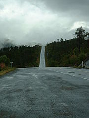 County road from Grong to Sweden
 -
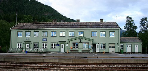 Train station in Grong
 -
 Foss i Grong


References[edit]
- ^ "Navn på steder og personer: Innbyggjarnamn" (in Norwegian). Språkrådet.
- ^ "Forskrift om målvedtak i kommunar og fylkeskommunar" (in Norwegian). Lovdata.no.
- ^ Bolstad, Erik; Thorsnæs, Geir, eds. (26 January 2023). "Kommunenummer". Store norske leksikon (in Norwegian). Kunnskapsforlaget.
- ^ Statistisk sentralbyrå. "Table: 06913: Population 1 January and population changes during the calendar year (M)" (in Norwegian).
- ^ Statistisk sentralbyrå. "09280: Area of land and fresh water (km²) (M)" (in Norwegian).
- ^ Jukvam, Dag (1999). "Historisk oversikt over endringer i kommune- og fylkesinndelingen" (PDF) (in Norwegian). Statistisk sentralbyrå.
- ^ Rygh, Oluf (1903). Norske gaardnavne: Nordre Trondhjems amt (in Norwegian) (15 ed.). Kristiania, Norge: W. C. Fabritius & sønners bogtrikkeri. p. 295.
- ^ "Civic heraldry of Norway - Norske Kommunevåpen". Heraldry of the World. Retrieved 11 February 2023.
- ^ "Grong, Nord-Trøndelag (Norway)". Flags of the World. Retrieved 11 February 2023.
- ^ "Godkjenning av våpen og flagg". Lovdata.no (in Norwegian). Norges kommunal- og arbeidsdepartementet. 6 February 1987. Retrieved 11 February 2023.
- ^ Hansen, Tore; Vabo, Signy Irene, eds. (20 September 2022). "kommunestyre". Store norske leksikon (in Norwegian). Kunnskapsforlaget. Retrieved 14 October 2022.
- ^ "Kommunestyrevalg 2023 - Trøndelag Trööndelage". Valgdirektoratet. Retrieved 6 January 2024.
- ^ "Tall for Norge: Kommunestyrevalg 2019 - Trøndelag". Valg Direktoratet. Retrieved 19 October 2019.
- ^ a b c d "Table: 04813: Members of the local councils, by party/electoral list at the Municipal Council election (M)" (in Norwegian). Statistics Norway.
- ^ "Tall for Norge: Kommunestyrevalg 2011 - Nord-Trøndelag". Valg Direktoratet. Retrieved 19 October 2019.
- ^ "Kommunestyrevalget 1995" (PDF) (in Norwegian). Oslo-Kongsvinger: Statistisk sentralbyrå. 1996. Retrieved 2 April 2020.
- ^ "Kommunestyrevalget 1991" (PDF) (in Norwegian). Oslo-Kongsvinger: Statistisk sentralbyrå. 1993. Retrieved 2 April 2020.
- ^ "Kommunestyrevalget 1987" (PDF) (in Norwegian). Oslo-Kongsvinger: Statistisk sentralbyrå. 1988. Retrieved 2 April 2020.
- ^ "Kommunestyrevalget 1983" (PDF) (in Norwegian). Oslo-Kongsvinger: Statistisk sentralbyrå. 1984. Retrieved 2 April 2020.
- ^ "Kommunestyrevalget 1979" (PDF) (in Norwegian). Oslo: Statistisk sentralbyrå. 1979. Retrieved 2 April 2020.
- ^ "Kommunevalgene 1975" (PDF) (in Norwegian). Oslo: Statistisk sentralbyrå. 1977. Retrieved 2 April 2020.
- ^ "Kommunevalgene 1972" (PDF) (in Norwegian). Oslo: Statistisk sentralbyrå. 1973. Retrieved 2 April 2020.
- ^ "Kommunevalgene 1967" (PDF) (in Norwegian). Oslo: Statistisk sentralbyrå. 1967. Retrieved 2 April 2020.
- ^ "Kommunevalgene 1963" (PDF) (in Norwegian). Oslo: Statistisk sentralbyrå. 1964. Retrieved 2 April 2020.
- ^ "Kommunevalgene og Ordførervalgene 1959" (PDF) (in Norwegian). Oslo: Statistisk sentralbyrå. 1960. Retrieved 2 April 2020.
- ^ "Kommunevalgene og Ordførervalgene 1955" (PDF) (in Norwegian). Oslo: Statistisk sentralbyrå. 1957. Retrieved 2 April 2020.
- ^ "Kommunevalgene og Ordførervalgene 1951" (PDF) (in Norwegian). Oslo: Statistisk sentralbyrå. 1952. Retrieved 2 April 2020.
- ^ "Kommunevalgene og Ordførervalgene 1947" (PDF) (in Norwegian). Oslo: Statistisk sentralbyrå. 1948. Retrieved 2 April 2020.
- ^ "Kommunevalgene og Ordførervalgene 1945" (PDF) (in Norwegian). Oslo: Statistisk sentralbyrå. 1947. Retrieved 2 April 2020.
- ^ "Kommunevalgene og Ordførervalgene 1937" (PDF) (in Norwegian). Oslo: Statistisk sentralbyrå. 1938. Retrieved 2 April 2020.
- ^ Bjerken, Martin (1950). Grong bygdebok for Grong, Harran, Namsskogan og Røyrvik (in Norwegian). Grong kommune. pp. 205–210.
- ^ Seem, Anne Marie (1999). Alle disse dager. Grong 1900–2000 (in Norwegian). Grong kommune. ISBN 9788291134321.
- ^ Strand, Jørgen P. (1990–1993). Grong bygdebok. Gårds- og slektshistorie (in Norwegian). Vol. 1–3. Grong kommune.
- ^ "Grong: Arbeiderpartiet får ordføreren". NRK Trøndelag (in Norwegian). 23 September 2023.
External links[edit]
 Trøndelag travel guide from Wikivoyage
- Municipal fact sheet from Statistics Norway (in Norwegian)
| |||||||||||||||
 | Towns and cities | ||||||||||||||
| Municipalities |
| ||||||||||||||
| |||||||||||||||
| International | |
|---|---|
| National | |