
Juliaca
Juliaca | |
|---|---|
| File:Juliaca-Rinconada.jpg | |
 Flag  Coat of arms | |
| Nickname: Ciudad de Los Vientos (The Windy City) | |
| Country | Peru |
| Region | Puno |
| Province | San Román |
| District | Juliaca |
| Founded | 1826 A.D. 1st |
| City since | 1908 A.D. 1st |
| Government | |
| • Type | Democracy |
| • Mayor | David Mamani Paricahua (2011–2014) |
| Elevation | 3,825 m (12,549 ft) |
| Population | |
| • Total | 225,146(2,007) |
| • Density | 422.6/km2 (1,095/sq mi) |
| Time zone | UTC-5 (PET) |
| • Summer (DST) | UTC-5 (PET) |
| Area code | +51 |
| Website | MuniJuliaca.gob.pe |
Juliaca (Spanish: Juliaca, Quechua: Hullaqa, Aymara: Hullaqa) is San Roman's capital city in the Puno Region, of southeastern Peru. It is the region's largest city with a population of 225,146 inhabitants (2007).[1] On the Altiplano, Juliaca is (3,825 metres (12,549 ft)) above sea level, is located on the Collao Plateau and is northwest of Lake Titicaca (45 km). It is the largest trade center in the Puno region.
Juliaca is near the Chacas lagoon, Maravillas river, and near the ruins of Sillustani.
The city hosts Juliaca's Carnival each year between February and March. During this very popular event participants, dressed in colorful costumes, gather on the streets to dance in the style of the Collao Plateau. Saint Sebastian's feast occurs on January 20 of every year.
Juliaca's citizens rely on cars, trains, and bicycles. It is a major transit point in the region and has strong ties with Peru's southern cities, including Arequipa, Puno, Tacna, Cuzco, Ilo, and with the Bolivian Republic.
Like Chicago, Illinois, it is nicknamed "The Windy City", because of the city's location on the windy Collao Plateau. It is also called the "Sock City" or "Knitting City" because Juliaca was a major center of sock, sweater, and handicraft production. Now the production of clothes, wool and fabrics are industrial processes.

It is also home to Inca Manco Capac Airport, the region's main airport.
Economy
Juliaca is a large trade center for goods and services, and is considered the financial capital of the Puno region. Trade is its principal economic activity, comprising 26.5% of the Labor force. In 2008, Juliaca had 15,439 commercial establishments,[2] which amounts to 41% of trade done in the Puno region.
The city of Juliaca has become a center of capital investment. As a result, poverty has been reduced, and increased per capita income has come to some of its residents.
Climate
Juliaca has an Alpine climate (Köppen Cwc) with cool to cold temperatures most of the year. The average annual precipitation is 610 mm. Winters are dry with very cold nights and mornings, and warm afternoons.


| Climate data for Juliaca, Peru (1961–1990) | |||||||||||||
|---|---|---|---|---|---|---|---|---|---|---|---|---|---|
| Month | Jan | Feb | Mar | Apr | May | Jun | Jul | Aug | Sep | Oct | Nov | Dec | Year |
| Mean daily maximum °C (°F) | 16.7 (62.1) |
16.7 (62.1) |
16.5 (61.7) |
16.8 (62.2) |
16.6 (61.9) |
16.0 (60.8) |
16.0 (60.8) |
17.0 (62.6) |
17.6 (63.7) |
18.6 (65.5) |
18.8 (65.8) |
17.7 (63.9) |
17.1 (62.8) |
| Mean daily minimum °C (°F) | 3.6 (38.5) |
3.5 (38.3) |
3.2 (37.8) |
0.6 (33.1) |
−3.8 (25.2) |
−7.0 (19.4) |
−7.5 (18.5) |
−5.4 (22.3) |
−1.4 (29.5) |
0.3 (32.5) |
1.5 (34.7) |
3.0 (37.4) |
−0.8 (30.6) |
| Average precipitation mm (inches) | 133.3 (5.25) |
108.7 (4.28) |
98.5 (3.88) |
43.3 (1.70) |
9.9 (0.39) |
3.1 (0.12) |
2.4 (0.09) |
5.8 (0.23) |
22.1 (0.87) |
41.1 (1.62) |
55.3 (2.18) |
85.9 (3.38) |
609.4 (23.99) |
| Source: Hong Kong Observatory,[3] | |||||||||||||
Picture gallery
-
 Franciscan Convent.
 -
 White Christ.
 -
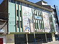 Calceteras Gallery.
 -
 1980's Train in Juliaca.
 -
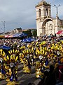 Juliaca´s Carnival.
 -
 Chacas Lagoon.


References
- ^ Peruvian Census
- ^ Peruvian government figures
- ^ "Climatological Information for Juliaca, Peru". Hong Kong Observatory.