Kolonnawa
Appearance
Kolonnawa
කොලොන්නාව கொலன்னாவ | |
|---|---|
town | |
| Coordinates: 6°55′42″N 79°53′42″E / 6.92833°N 79.89500°E | |
| Country | Sri Lanka |
| Province | Western Province |
| District | Colombo District |
| Population (2012[1]) | |
| • Total | 64,887 |
| Time zone | +5.30 |
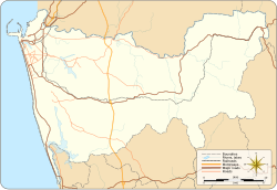
Kolonnawa (Sinhala: කොලොන්නාව, Template:Lang-ta) is a town located on the eastern boundary of Colombo District, Western Province of Sri Lanka. It is bounded by Kelani River to the north, Kotikawatta-Mulleriyawa Pradeshiya Sabha to the East, Kotte Municipal Council to the south and Colombo Municipal Council to the west.
Kolonnawa Urban Council
Zone [2]
- Kolonnawa
- Orugodawatte
- Wellampitiya
Demographics
Kolonnawa Municipality area is a multi-ethnic, multi-religious urban centre. According to the census of 2012, the demographics by ethnicity and religion is as follows:.
| 2012 | Percentage | |
|---|---|---|
| Buddhist | 123,225 | 64.58% |
| Islam | 43,988 | 23.05% |
| Hindu | 12,991 | 6.81% |
| Roman Catholic | 7,327 | 3.84% |
| Other Christian | 3,245 | 1.70% |
| Other | 41 | 0.02% |
| Total | 190,817 | 100.00% |
| Sinhalese | 128,623 | 67.41% |
| Sri Lankan Moor | 40,412 | 21.18% |
| Sri Lankan Tamil | 15,934 | 8.35% |
| Indian Tamil | 2,101 | 1.10% |
| Malay | 1,885 | 0.99% |
| Burgher | 1,301 | 0.68% |
| Other | 487 | 0.26% |
| Sri Lankan Chetty | 57 | 0.03% |
| Baratha | 17 | 0.01% |
| Total | 190,817 | 100.00% |
References
- ^ "Sri Lanka - largest cities (per geographical entity)". World Gazetteer. Retrieved 2012-12-17.
{{cite web}}: External link in|publisher= - ^ "Ward Maps of Colombo District – Kolonnawa Urban Council" (PDF). Archived from the original (PDF) on 2018-09-21. Retrieved 2018-04-14.
- ^ "Department of Census and Statistics Sri Lanka - Population by ethnicity and district according to Divisional Secretary's Division, 2012".
- ^ "Department of Census and Statistics Sri Lanka - Population by divisional secretariat division, religion and sex- 2012" (PDF).

