Long Island Recreation Park
| Long Island Recreation Park South Australia | |
|---|---|
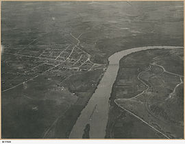
 Aerial view of Murray Bridge including north end of Long Island, circa 1920 (State Library of South Australia B 11533) | |
| Nearest town or city | Murray Bridge |
| Coordinates | 35°7′49.44″S 139°18′1.07″E / 35.1304000°S 139.3002972°E[1] |
| Established | 9 October 1958[2][3] |
| Area | 8 hectares (20 acres)[2] |
| Managing authorities | Department for Environment and Water |
| See also | Protected areas of South Australia |
Long Island Recreation Park is a protected area in the Australian state of South Australia occupying the full extent of Long Island in the Murray River immediately east of the city of Murray Bridge.[4]
The island forming the recreation park first received protected area status on 9 October 1958 as a recreation reserve proclaimed under Crown Lands Act 1929 and to be managed by the Corporate Town of Murray Bridge.[3] On 1 September 1966, it was proclaimed as a fauna sanctuary under the Fauna Conservation Act, 1964-1965.[5] On 8 July 1976, the recreation reserve was resumed under Crown Lands Act 1929 and then proclaimed as the Long Island Recreation Park under the National Parks and Wildlife Act 1972.[6][7]
As of 1980, it was reported as having "aesthetic and recreational value", as being a refuge for waterfowl and as supporting "a dense forest of introduced willow species with emergent Eucalyptus camaldulensis".[8]
The recreation park is classified as an IUCN Category III protected area. In 1980, the recreation park was listed on the former Register of the National Estate.[1][8]
See also[edit]
References[edit]
- ^ a b c "Terrestrial Protected Areas of South Australia (refer 'DETAIL' tab )". CAPAD 2016. Australian Government, Department of the Environment (DoE). 2016. Retrieved 21 February 2018.
- ^ a b "Protected Areas Information System Reserve List" (PDF). Government of South Australia. 9 March 2018. Retrieved 26 April 2018.
- ^ a b McEwin, A. Lyell (9 October 1958). "CROWN LANDS ACT, 1929-1957: HUNDREDS OF MOBILONG AND BURDETT-RECREATION RESERVES RESUMED AND DEDICATED" (PDF). The South Australian Government Gazette. South Australian Government. p. 1016. Retrieved 22 May 2018.
- ^ Boating Industry Association of South Australia (BIA); South Australia. Department for Environment and Heritage (2005), South Australia's waters an atlas & guide, Boating Industry Association of South Australia, p. 61, ISBN 978-1-86254-680-6
- ^ Shard, A.J. (1 September 1966). "FAUNA CONSERVATION ACT, 1964-1965: HUNDREDS OF MOBILONG AND BURDETT—FAUNA SANCTUARY DECLARED" (PDF). The South Australian Government Gazette. South Australian Government. p. 1126. Retrieved 22 May 2018.
- ^ Banfield, D.H. (8 July 1976). "CROWN LANDS ACT, 1929-1975: HUNDRED OF MOBILONG—RECREATION RESERVE RESUMED" (PDF). The South Australian Government Gazette. Government of South Australia. p. 74. Retrieved 28 December 2018.
- ^ Banfield, D.H. (8 July 1976). "NATIONAL PARKS AND WILDLIFE ACT, 1972-1974: LONG ISLAND RECREATION PARK CONSTITUTED" (PDF). The South Australian Government Gazette. Government of South Australia. p. 74. Retrieved 28 December 2018.
- ^ a b "Long Island Recreation Park, Long Island Rd, Murray Bridge, SA, Australia - listing on the now-defunct Register of the National Estate (Place ID 7930)". Australian Heritage Database. Australian Government. Retrieved 22 May 2018.

