
National Register of Historic Places listings in Northwest Portland, Oregon
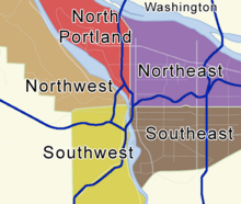
This list presents the full set of buildings, structures, objects, sites, or districts designated on the National Register of Historic Places in Northwest Portland, Oregon, and offers brief descriptive information about each of them. The National Register recognizes places of national, state, or local historic significance across the United States.[1] Out of over 90,000 National Register sites nationwide,[2] Oregon is home to over 2,000,[3] and over one-fourth of those are found partially or wholly in Portland. While these sites are widely spread across all six of Portland's quadrants, heavy concentrations are found in the Downtown and Southwest Hills neighborhoods of the Southwest quadrant, and the Northwest District neighborhood of the Northwest quadrant.
Only historic places within the municipal boundaries of Portland are shown in this list and its four companion lists for the other quadrants. Some sites beyond city limits will appear in other lists showing "Portland" as a general locality, but are excluded here. Although Portland's legal boundaries extend into Clackamas and Washington counties, all of the city's National Register sites lie within Multnomah County.
This National Park Service list is complete through NPS recent listings posted May 3, 2024.[4]
Current listings[edit]
| [5] | Name on the Register | Image | Date listed[6] | Location | Description |
|---|---|---|---|---|---|
| 1 | Charles F. Adams House |  |
December 9, 1981 (#81000513) |
2363 NW Flanders Street 45°31′33″N 122°41′59″W / 45.525716°N 122.699844°W |
Charles Francis Adams (1862–1943) was a prominent Portland banker, art collector, and patron of the Portland Art Museum. This house was designed for him by the eminent firm of Whidden and Lewis, built in the Georgian Revival style in 1904, expanded in 1918, and extensively restored in 1979. Adams lived there for 39 years until his death.[7] |
| 2 | Albers Brothers Milling Company |  |
November 15, 1984 (#84000480) |
1118–1130 NW Front Avenue 45°31′52″N 122°40′34″W / 45.531047°N 122.676205°W |
In the early decades of the 20th century, the German-immigrant Albers brothers built the largest flour and feed milling enterprise on the West Coast, headquartered in Portland and comprising operations in four states. This combined milling, warehousing, shipping, and office facility, built in 1909–11, is the oldest remaining flour or feed mill in the city.[8] |
| 3 | Alphabet Historic District |  |
November 16, 2000 (#00001293) |
Roughly bounded by NW Lovejoy and Marshall Streets, NW 17th Avenue, W Burnside Street, and NW 24th Avenue 45°31′36″N 122°41′42″W / 45.52666°N 122.6949°W |
|
| 4 | American Apartment Building |  |
May 27, 1993 (#93000452) |
2083 NW Johnson Street 45°31′43″N 122°41′39″W / 45.528644°N 122.694241°W |
The 5-story commercial-type building designed by William B. Bell was built in 1911. It is also known as American Ballparc Condominium. Its siding consists of brick and concrete. |
| 5 | American Can Company Complex |  |
September 12, 1996 (#96000996) |
2127 NW 26th Avenue 45°32′17″N 122°42′21″W / 45.538124°N 122.705922°W |
|
| 6 | Mark A. M. Ashley House |  |
March 2, 1979 (#79002126) |
2847 NW Westover Road 45°31′55″N 122°42′32″W / 45.532035°N 122.708873°W |
|
| 7 | W. B. Ayer House |  |
February 22, 1991 (#91000144) |
811 NW 19th Avenue 45°31′43″N 122°41′28″W / 45.528746°N 122.690978°W |
|
| 8 | Ayer–Shea House |  |
June 14, 1982 (#82003741) |
1809 NW Johnson Street 45°31′44″N 122°41′23″W / 45.528773°N 122.689759°W |
|
| 9 | Ballou & Wright Company Building |  |
April 30, 1987 (#87000698) |
327 NW 10th Avenue 45°31′32″N 122°40′54″W / 45.525613°N 122.681542°W |
|
| 10 | Bates–Seller House |  |
August 29, 1979 (#79002127) |
2381 NW Flanders Street 45°31′33″N 122°42′01″W / 45.525715°N 122.700224°W |
|
| 11 | Christine Becker House |  |
February 28, 1991 (#91000142) |
1331 NW 25th Avenue 45°31′57″N 122°42′11″W / 45.532380°N 122.703045°W |
|
| 12 | Belle Court Apartments |  |
November 6, 1986 (#86002966) |
120 NW Trinity Place 45°31′26″N 122°41′28″W / 45.524014°N 122.691035°W |
|
| 13 | Joseph Bergman House |  |
September 1, 1983 (#83002168) |
2134 NW Hoyt Street 45°31′37″N 122°41′43″W / 45.526809°N 122.695259°W |
|
| 14 | Biltmore Apartments |  |
February 20, 1991 (#91000041) |
2014 NW Glisan Street 45°31′34″N 122°41′34″W / 45.526080°N 122.692816°W |
|
| 15 | J. C. Braly House |  |
February 28, 1991 (#91000132) |
2846 NW Fairfax Terrace 45°31′53″N 122°42′35″W / 45.531285°N 122.709781°W |
|
| 16 | Bretnor Apartments |  |
February 20, 1991 (#91000067) |
931 NW 20th Avenue 45°31′47″N 122°41′34″W / 45.529743°N 122.692873°W |
|
| 17 | Broadway Bridge |  |
November 14, 2012 (#12000930) |
Spanning the Willamette River at river mile 11.7 45°31′55″N 122°40′26″W / 45.531816°N 122.673898°W |
This is the largest example of a Rall-type bascule bridge ever constructed, and one of only three such designs still extant in the United States. Completed in 1913, it was an important step in the development of Portland's transportation system, as the city's first Willamette River bridge built on an entirely new alignment in the 20th century.[9] |
| 18 | Broadway Hotel |  |
September 9, 1993 (#93000927) |
10 NW Broadway 45°31′24″N 122°40′38″W / 45.523299°N 122.677126°W |
|
| 19 | Buck Apartment Building |  |
October 25, 1990 (#90001594) |
415 NW 21st Avenue 45°31′33″N 122°41′41″W / 45.525858°N 122.694656°W |
|
| 20 | Burke–Clark House |  |
August 26, 1982 (#82003742) |
2610 NW Cornell Road 45°31′47″N 122°42′18″W / 45.529701°N 122.705113°W |
|
| 21 | Burnside Bridge |  |
November 14, 2012 (#12000931) |
Spanning the Willamette River at river mile 12.7 45°31′23″N 122°40′03″W / 45.523037°N 122.667632°W |
Opened in 1926 as a centerpiece of Portland's transportation system, the Burnside Bridge was embroiled in a public corruption scandal during its development. Part of a three-bridge package funded by a public bond issue, it was one of the final works in bridge engineer Gustav Lindenthal's impressive career.[a] It is one of the country's heaviest bascule bridges, and the earliest to use a concrete deck on the lift span.[10] |
| 22 | Campbell Hotel |  |
February 22, 1988 (#88000098) |
530 NW 23rd Avenue 45°31′36″N 122°41′54″W / 45.526741°N 122.698231°W |
|
| 23 | Campbell Townhouses |  |
February 12, 1980 (#80003360) |
1705–1719 NW Irving Street 715–719 NW 17th Avenue 45°31′41″N 122°41′19″W / 45.528077°N 122.688729°W |
|
| 24 | Cardwell–Holman House |  |
September 21, 2005 (#05001057) |
827 NW 25th Avenue 45°31′56″N 122°42′00″W / 45.532132°N 122.700036°W |
|
| 25 | Clarke–Mossman House |  |
December 6, 2002 (#02001484) |
1625 NW 29th Avenue 45°32′03″N 122°42′40″W / 45.534298°N 122.711211°W |
|
| 26 | Cohn–Sichel House |  |
February 28, 2008 (#08000119) |
2205 NW Johnson Street 45°31′43″N 122°41′48″W / 45.5286°N 122.6968°W |
|
| 27 | Couch Family Investment Development |  |
February 25, 1980 (#80003362) |
1721–1735 NW Irving Street and 718 NW 18th Avenue 45°31′41″N 122°41′21″W / 45.528081°N 122.689145°W |
|
| 28 | Darcelle XV |  |
November 2, 2020 (#100005723) |
208 NW 3rd Ave. 45°31′29″N 122°40′24″W / 45.5247°N 122.6734°W |
|
| 29 | Day Building |  |
October 2, 1978 (#78002310) |
2068 NW Flanders Street 45°31′31″N 122°41′38″W / 45.525381°N 122.693807°W |
|
| 30 | Dayton Apartment Building |  |
December 21, 1981 (#81000515) |
2056–2058 NW Flanders Street 45°31′31″N 122°41′37″W / 45.525387°N 122.693615°W |
|
| 31 | Frank E. Dooly House |  |
October 24, 1980 (#80003364) |
2670 NW Lovejoy Street 45°31′45″N 122°42′21″W / 45.529224°N 122.705814°W |
|
| 32 | Henry E. Dosch Investment Property |  |
June 4, 1987 (#87000886) |
425 NW 18th Avenue 45°31′34″N 122°41′23″W / 45.526109°N 122.689636°W |
|
| 33 | Elizabeth Ducey House |  |
June 1, 1990 (#90000839) |
2773 NW Westover Road 45°31′51″N 122°42′27″W / 45.530773°N 122.707597°W |
|
| 34 | Eastman–Shaver House |  |
July 9, 1985 (#85001528) |
2645 NW Beuhla Vista Terrace 45°31′32″N 122°42′18″W / 45.525618°N 122.705073°W |
|
| 35 | Eugene Apartments |  |
August 26, 1994 (#94001023) |
2030 NW Flanders Street 45°31′31″N 122°41′35″W / 45.525361°N 122.693080°W |
|
| 36 | Fairmount Hotel |  |
May 5, 2000 (#00000448) |
1908–1932 NW 26th Avenue 45°32′11″N 122°42′17″W / 45.536464°N 122.704608°W |
|
| 37 | First Church of Christ, Scientist |  |
October 2, 1978 (#78002314) |
1819 NW Everett Street 45°31′31″N 122°41′23″W / 45.525182°N 122.689846°W |
|
| 38 | First Regiment Armory Annex |  |
August 31, 2000 (#00001017) |
128 NW 11th Avenue 45°31′27″N 122°40′54″W / 45.524166°N 122.681639°W |
Built in 1888 in reaction to anti-Chinese riots along the West Coast, to provide drilling space for the National Guard, this extension to the Portland armory evolved into a de facto cultural center hosting opera, early movies, political events, boxing, concerts, and other events.[11] After standing abandoned for decades, it reopened as a theater in 2006.[12] |
| 39 | G. G. Gerber Building |  |
September 6, 2007 (#07000922) |
210 NW 11th Avenue 45°31′29″N 122°40′55″W / 45.524609°N 122.681872°W |
|
| 40 | Golden West Hotel |  |
February 22, 2022 (#100007456) |
707 NW Everett St. 45°31′31″N 122°40′40″W / 45.5252°N 122.6778°W |
|
| 41 | Bernard and Emma Goldsmith House |  |
October 25, 2018 (#100003054) |
1507 NW 24th Avenue 45°32′01″N 122°42′04″W / 45.533477°N 122.701104°W |
|
| 42 | Joseph Goodman House |  |
May 27, 1993 (#93000455) |
240 NW 20th Avenue 45°31′29″N 122°41′31″W / 45.524753°N 122.692082°W |
|
| 43 | Henry M. Grant House |  |
February 22, 1991 (#91000148) |
3114 NW Thurman Street 45°32′08″N 122°42′51″W / 45.535523°N 122.714073°W |
|
| 44 | Henry Hahn House |  |
September 9, 1993 (#93000918) |
2636 NW Cornell Road 45°31′49″N 122°42′21″W / 45.530328°N 122.705842°W |
|
| 45 | Hazel Hall House |  |
June 19, 1991 (#91000813) |
104–106 NW 22nd Place 45°31′26″N 122°41′50″W / 45.523967°N 122.697181°W |
|
| 46 | Alexander B. and Anna Balch Hamilton House |  |
February 11, 1993 (#93000021) |
2723–2729 NW Savier Street 45°32′05″N 122°42′27″W / 45.534789°N 122.707442°W |
|
| 47 | Harlow Block |  |
October 24, 1980 (#80003366) |
720–738 NW Glisan Street 45°31′35″N 122°40′42″W / 45.526458°N 122.678293°W |
|
| 48 | Harmon–Neils House |  |
February 16, 1984 (#84003080) |
2642 NW Lovejoy Street 45°31′45″N 122°42′19″W / 45.529279°N 122.705269°W |
|
| 49 | Dr. Harry M. Hendershott House |  |
June 19, 1991 (#91000797) |
824 NW Albemarle Terrace 45°31′44″N 122°42′26″W / 45.528986°N 122.707236°W |
|
| 50 | George F. Heusner House |  |
October 19, 1978 (#78002316) |
333 NW 20th Avenue 45°31′32″N 122°41′34″W / 45.525437°N 122.692756°W |
|
| 51 | Hill Hotel |  |
June 9, 1995 (#95000690) |
2255–2261 W Burnside Street 45°31′25″N 122°41′51″W / 45.52354°N 122.6976°W |
This 5-story Beaux Arts building designed by Alexander Charles Ewart was built in 1904 and used as a hotel. It is also known as Victorian Inn. |
| 52 | Capt. Herbert Holman House |  |
February 22, 1991 (#91000136) |
2359 NW Overton Street 45°31′55″N 122°42′00″W / 45.53193°N 122.6999°W |
|
| 53 | Honeyman Hardware Company Building |  |
December 15, 1989 (#89002124) |
832 NW Hoyt Street 45°31′37″N 122°40′47″W / 45.526931°N 122.679745°W |
|
| 54 | Walter B. and Myrtle E. Honeyman House |  |
September 10, 2014 (#14000598) |
2658 NW Cornell Road 45°31′51″N 122°42′23″W / 45.530806°N 122.706386°W |
|
| 55 | Clarissa McKeyes Inman House |  |
February 23, 1990 (#90000275) |
2884 NW Cumberland Road 45°31′43″N 122°42′38″W / 45.528626°N 122.710616°W |
|
| 56 | Irving Street Bowman Apartments |  |
February 23, 1990 (#90000291) |
2004–2018 NW Irving Street 45°31′39″N 122°41′34″W / 45.527546°N 122.692817°W |
|
| 57 | C. D. Johnson House |  |
February 22, 1991 (#91000146) |
2582 NW Lovejoy Street 45°31′46″N 122°42′16″W / 45.529497°N 122.704369°W |
|
| 58 | C. A. Landenberger House |  |
February 29, 1988 (#88000097) |
1805 NW Glisan Street 45°31′36″N 122°41′23″W / 45.526556°N 122.689630°W |
|
| 59 | Lane – Miles Standish Company Printing Plant |  |
March 27, 2007 (#07000262) |
1539 NW 19th Avenue 45°32′02″N 122°41′28″W / 45.533919°N 122.691010°W |
|
| 60 | Lauer Apartment Building |  |
March 5, 1992 (#92000089) |
323–337 NW 17th Avenue 45°31′32″N 122°41′19″W / 45.525480°N 122.688532°W |
|
| 61 | William H. Lewis Model House |  |
March 6, 1990 (#90000274) |
2877 NW Westover Road 45°31′57″N 122°42′36″W / 45.532478°N 122.709866°W |
|
| 62 | Linnea Hall |  |
December 2, 1981 (#81000517) |
2066 NW Irving Street 45°31′39″N 122°41′38″W / 45.527580°N 122.693886°W |
|
| 63 | C. J. Livingston House |  |
January 27, 2012 (#11001064) |
407 NW Albemarle Terrace 45°31′35″N 122°42′20″W / 45.526515°N 122.705429°W |
|
| 64 | Nathan Loeb House |  |
January 20, 1978 (#78002318) |
726 NW 22nd Avenue 45°31′41″N 122°41′47″W / 45.528143°N 122.696264°W |
|
| 65 | Lombard Automobile Buildings |  |
January 26, 2006 (#05001553) |
134 NW 8th Avenue 45°31′27″N 122°40′41″W / 45.524244°N 122.677999°W |
|
| 66 | Dr. K. A. J. and Cora Mackenzie House |  |
May 31, 1996 (#96000625) |
615 NW 20th Avenue 45°31′38″N 122°41′34″W / 45.527318°N 122.692833°W |
|
| 67 | Marshall–Wells Company Warehouse No. 2 |  |
February 23, 1989 (#89000061) |
1420 NW Lovejoy Street 45°31′47″N 122°41′09″W / 45.529674°N 122.685948°W |
|
| 68 | Alexander D. McDougall House |  |
March 18, 1999 (#99000359) |
3814 NW Thurman Street 45°32′22″N 122°43′18″W / 45.539459°N 122.721682°W |
|
| 69 | Natt and Christena McDougall House |  |
March 18, 1999 (#99000358) |
3728 NW Thurman Street 45°32′21″N 122°43′16″W / 45.539297°N 122.721160°W |
|
| 70 | McDougall–Campbell House |  |
February 25, 2005 (#05000095) |
3846 NW Thurman Street 45°32′23″N 122°43′20″W / 45.539637°N 122.722165°W |
|
| 71 | Meier & Frank Delivery Depot | .jpg) |
September 3, 2001 (#01000936) |
1417 NW Everett Street 45°31′31″N 122°41′09″W / 45.525384°N 122.685800°W |
|
| 72 | Meier & Frank Warehouse |  |
August 31, 2000 (#00001021) |
1400–1438 NW Irving Street 45°31′39″N 122°41′09″W / 45.527520°N 122.685844°W |
|
| 73 | Lewis H. Mills House |  |
August 26, 1982 (#82003745) |
2039 NW Irving Street 45°31′40″N 122°41′36″W / 45.527914°N 122.693391°W |
|
| 74 | Montgomery Ward & Company |  |
June 6, 1985 (#85001184) |
2741 NW Vaughn Street 45°32′15″N 122°42′28″W / 45.537472°N 122.707915°W |
|
| 75 | Melinda E. Morgan House |  |
October 25, 1990 (#90001592) |
3115 NW Thurman Street 45°32′10″N 122°42′50″W / 45.536033°N 122.713998°W |
|
| 76 | Paul F. Murphy House |  |
February 22, 1991 (#91000138) |
850 NW Powhatan Terrace 45°31′44″N 122°42′43″W / 45.528992°N 122.711988°W |
|
| 77 | Isaac Neuberger House |  |
October 17, 1990 (#90001512) |
630 NW Alpine Terrace 45°31′38″N 122°42′38″W / 45.527357°N 122.710552°W |
|
| 78 | New Houston Hotel |  |
February 20, 1991 (#91000058) |
230 NW 6th Avenue 45°31′29″N 122°40′35″W / 45.52474°N 122.6765°W |
|
| 79 | Harry T. Nicolai House |  |
October 17, 1990 (#90001511) |
2621 NW Westover Road 45°31′42″N 122°42′21″W / 45.52835°N 122.7057°W |
|
| 80 | North Bank Depot Buildings | ,_March_2000_-_Portland,_Oregon.jpg) |
February 22, 1996 (#96000124) |
1029–1101 NW Hoyt Street 45°31′39″N 122°40′56″W / 45.52755°N 122.6823°W |
|
| 81 | Olympic Apartment Building |  |
February 21, 1997 (#97000128) |
707 NW 19th Avenue 45°31′41″N 122°41′27″W / 45.528011°N 122.690743°W |
|
| 82 | Oregon Cracker Company Building |  |
August 10, 1979 (#79002138) |
616 NW Glisan Street 45°31′35″N 122°40′37″W / 45.526396°N 122.676851°W |
Built around 1897 as a food processing plant, and expanded in 1901, this is one of Portland's finest Romansque Revival buildings. The building also includes early examples of structural features that were innovative for the time, but which later became common.[13] |
| 83 | Ormonde Apartment Building |  |
September 8, 1987 (#87001493) |
2046–2048 NW Flanders Street 45°31′31″N 122°41′36″W / 45.525404°N 122.693423°W |
|
| 84 | Otis Elevator Company Building |  |
February 11, 1988 (#88000095) |
230 NW 10th Avenue 45°31′29″N 122°40′52″W / 45.52465°N 122.6811°W |
|
| 85 | Pacific Coast Biscuit Company Building |  |
March 5, 1998 (#98000212) |
1101–1129 NW Davis Street 45°31′28″N 122°40′57″W / 45.5244°N 122.6825°W |
|
| 86 | Pacific Hardware & Steel Company Warehouse |  |
December 31, 2008 (#08001263) |
2181 NW Nicolai Street 45°32′30″N 122°41′50″W / 45.54155°N 122.697108°W |
|
| 87 | Packard Service Building |  |
January 28, 1994 (#93001570) |
121 NW 23rd Avenue 45°31′27″N 122°41′55″W / 45.524229°N 122.698715°W |
|
| 88 | Pallay Building |  |
November 8, 1985 (#85003503) |
231–239 NW 3rd Avenue 45°31′31″N 122°40′24″W / 45.52518°N 122.6734°W |
|
| 89 | J. J. and Hazel Parker House |  |
October 12, 2023 (#100009462) |
2911 NW Raleigh Street 45°32′02″N 122°42′40″W / 45.5339°N 122.7112°W |
|
| 90 | J. H. Peterson Machine Shop |  |
October 16, 2002 (#02001181) |
1626 NW Thurman Street 45°32′08″N 122°41′17″W / 45.53568°N 122.688°W |
|
| 91 | Pittock Mansion |  |
November 21, 1974 (#74001709) |
3229 NW Pittock Drive 45°31′29″N 122°43′02″W / 45.52472°N 122.7172°W |
|
| 92 | Otho Poole House |  |
February 28, 1991 (#91000150) |
506 NW Hermosa Boulevard 45°31′32″N 122°42′35″W / 45.525572°N 122.70985°W |
|
| 93 | Portland Buddhist Church |  |
January 21, 2004 (#03001476) |
312 NW 10th Avenue 45°31′31″N 122°40′52″W / 45.52526°N 122.6812°W |
[1] |
| 94 | Portland Cordage Company Building |  |
February 11, 1993 (#93000018) |
1313 NW Marshall Street 45°31′51″N 122°41′05″W / 45.53077°N 122.6846°W |
|
| 95 | Portland Fire Station No. 17 |  |
March 12, 1987 (#87000311) |
824 NW 24th Avenue 45°31′44″N 122°42′01″W / 45.528767°N 122.700348°W |
|
| 96 | Portland New Chinatown–Japantown Historic District | .jpg) |
November 21, 1989 (#89001957) |
Bounded by NW Glisan Street, NW 3rd Avenue, W Burnside Street, and NW 5th Avenue 45°31′30″N 122°40′28″W / 45.52496°N 122.6744°W |
|
| 97 | Portland Skidmore/Old Town Historic District |  |
December 6, 1975 (#75001597) |
Roughly bounded by the Willamette River,[14] NW Everett Street, NW/SW 3rd Avenue, and SW Oak Street 45°31′21″N 122°40′18″W / 45.52242°N 122.6718°W |
One of the most impressive historic commercial districts on the West Coast, this is where Portland began and first flourished. The buildings, which date from the mid-to-late-19th century, were built in a variety of High Victorian architectural styles, and many feature cast iron fronts.[15] Also extends into Southwest Portland. |
| 98 | Portland Thirteenth Avenue Historic District |  |
June 15, 1987 (#87000888) |
Along NW 13th Avenue between NW Davis and Johnson Streets 45°31′38″N 122°41′03″W / 45.5272°N 122.6843°W |
|
| 99 | Prager–Lombard House |  |
February 22, 1991 (#91000149) |
2032 NW Everett Street 45°31′29″N 122°41′35″W / 45.524721°N 122.693085°W |
|
| 100 | Regent Apartments |  |
February 20, 1991 (#91000044) |
1975 NW Everett Street 45°31′30″N 122°41′31″W / 45.525121°N 122.691913°W |
|
| 101 | Dr. Leo Ricen House |  |
March 9, 1992 (#92000086) |
2624 NW Overton Street 45°31′54″N 122°42′18″W / 45.5318°N 122.705°W |
|
| 102 | Rose City Electric Automobile Garage |  |
February 22, 1996 (#96000122) |
124 NW 20th Avenue 45°31′27″N 122°41′31″W / 45.524090°N 122.692029°W |
|
| 103 | St. Patrick's Roman Catholic Church and Rectory | .jpg) |
May 1, 1974 (#74001713) |
1635 NW 19th Avenue 45°32′05″N 122°41′28″W / 45.534675°N 122.691033°W |
|
| 104 | Sengstake Building |  |
October 31, 2012 (#12000901) |
310 NW Broadway 45°31′32″N 122°40′39″W / 45.525435°N 122.677365°W |
|
| 105 | Seven Hundred Five Davis Street Apartments |  |
October 10, 1980 (#80003374) |
2141 NW Davis Street 45°31′28″N 122°41′43″W / 45.524349°N 122.695393°W |
This 7-story Neo-Renaissance building designed by Whitehouse & Fouilhoux was built in 1913 and quickly became one of Portland's most fashionable addresses due to its fine design and materials and large rooms. Its original owner, Julia Hoffman (1856–1934), was a major figure in the Portland arts community, both as practitioner and advocate.[b] She lived in the building's penthouse until her death.[16] |
| 106 | Mary J. G. Smith House |  |
December 2, 1981 (#81000519) |
2256 NW Johnson Street 45°31′41″N 122°41′52″W / 45.528137°N 122.697783°W |
|
| 107 | Spokane, Portland and Seattle Railroad Warehouse |  |
October 3, 1996 (#96001071) |
1631 NW Thurman Street 45°32′09″N 122°41′17″W / 45.53571°N 122.688°W |
|
| 108 | Sprague–Marshall–Bowie House |  |
February 5, 1980 (#80003375) |
2234 NW Johnson Street 45°31′41″N 122°41′51″W / 45.528141°N 122.697372°W |
|
| 109 | John A. Sprouse Jr. House |  |
February 19, 1991 (#91000068) |
2826 NW Cumberland Road 45°31′46″N 122°42′30″W / 45.52943°N 122.7084°W |
|
| 110 | Frank C. Stettler House |  |
February 23, 1990 (#90000287) |
2606 NW Lovejoy Street 45°31′47″N 122°42′16″W / 45.52965°N 122.7045°W |
|
| 111 | Francis Marion Stokes Fourplex |  |
February 22, 1996 (#96000121) |
2253 NW Pettygrove Street 45°31′58″N 122°41′52″W / 45.53268°N 122.6977°W |
|
| 112 | Swedish Evangelical Mission Covenant Church |  |
October 7, 1982 (#82001514) |
1624 NW Glisan Street 45°31′34″N 122°41′17″W / 45.526221°N 122.688149°W |
|
| 113 | Sweeney, Straub and Dimm Printing Plant |  |
June 16, 2004 (#04000615) |
535 NW 16th Avenue 45°31′37″N 122°41′17″W / 45.526930°N 122.687933°W |
|
| 114 | Ernest G. Swigert House |  |
February 28, 1991 (#91000134) |
720 NW Warrenton Terrace 45°31′41″N 122°42′49″W / 45.52792°N 122.7136°W |
|
| 115 | Albert H. Tanner House |  |
March 11, 1983 (#83002175) |
2248 NW Johnson Street 45°31′41″N 122°41′51″W / 45.528137°N 122.697582°W |
|
| 116 | Louis and Bessie Tarpley House |  |
August 23, 2007 (#07000843) |
2520 NW Westover Road 45°31′43″N 122°42′12″W / 45.5287°N 122.7034°W |
|
| 117 | Fred E. Taylor House |  |
October 17, 1990 (#90001519) |
2873 NW Shenandoah Terrace 45°31′51″N 122°42′36″W / 45.53075°N 122.7099°W |
|
| 118 | Temple Beth Israel |  |
July 26, 1979 (#79002141) |
1931 NW Flanders Street 45°31′34″N 122°41′27″W / 45.526008°N 122.690956°W |
|
| 119 | Trenkmann Houses |  |
January 30, 1978 (#78002323) |
1704–1734 NW Hoyt Street 45°31′37″N 122°41′20″W / 45.526899°N 122.688870°W |
|
| 120 | Trevett–Nunn House |  |
February 5, 1980 (#80003376) |
2347–2349 NW Flanders Street 45°31′33″N 122°41′58″W / 45.525734°N 122.699501°W |
The 2.5-story residential building was erected in 1891 by the prominent architectural firm Whidden & Lewis in the Colonial Revival style and is located in the Alphabet Historic District. |
| 121 | Trinity Place Apartments |  |
February 23, 1990 (#90000294) |
117 NW Trinity Place 45°31′26″N 122°41′30″W / 45.523955°N 122.691678°W |
|
| 122 | Tudor Arms Apartments |  |
January 28, 1994 (#93001562) |
1811 NW Couch Street 45°31′26″N 122°41′22″W / 45.523770°N 122.689582°W |
|
| 123 | Union Station |  |
August 6, 1975 (#75001595) |
800 NW 6th Avenue 45°31′45″N 122°40′36″W / 45.52915°N 122.6767°W |
|
| 124 | U.S. Customhouse |  |
May 2, 1974 (#74001714) |
220 NW 8th Avenue 45°31′29″N 122°40′43″W / 45.52464°N 122.6785°W |
|
| 125 | U.S. Post Office | .jpg) |
April 18, 1979 (#79002143) |
511 NW Broadway 45°31′37″N 122°40′41″W / 45.526949°N 122.678127°W |
|
| 126 | Frank M. Warren House |  |
June 16, 1989 (#89000509) |
2545 NW Westover Road 45°31′43″N 122°42′12″W / 45.52869°N 122.7034°W |
|
| 127 | Weinhard Brewery Complex | .jpg) |
August 23, 2000 (#00001018) |
1131–1133 W Burnside Street 45°31′23″N 122°40′57″W / 45.52297°N 122.6825°W |
|
| 128 | Weist Apartments |  |
February 23, 1990 (#90000293) |
209 NW 23rd Avenue 45°31′28″N 122°41′56″W / 45.524418°N 122.698756°W |
|
| 129 | Isam White House |  |
October 17, 1991 (#91001557) |
311 NW 20th Avenue 45°31′31″N 122°41′34″W / 45.525148°N 122.692756°W |
|
| 130 | Wickersham Apartments |  |
March 10, 1983 (#83002178) |
410 NW 18th Avenue 45°31′33″N 122°41′21″W / 45.525908°N 122.689122°W |
|
| 131 | George H. Williams Townhouses |  |
March 22, 1984 (#84003097) |
133 NW 18th Avenue 45°31′27″N 122°41′22″W / 45.524050°N 122.689557°W |
|
| 132 | Wilson–South House |  |
January 27, 1999 (#99000065) |
2772 NW Calumet Terrace 45°31′29″N 122°42′32″W / 45.52476°N 122.7089°W |
Former listings[edit]
| [5] | Name on the Register | Image | Date listed | Date removed | Location | Description |
|---|---|---|---|---|---|---|
| 1 | Capt. John A. Brown House | October 26, 1971 (#71001086) | December 13, 2010[17] | 525 NW 19th Ave. |
Demolished in 1973. | |
| 2 | Clarke–Woodward Drug Company Building | March 2, 1989 (#89000121) | August 2, 2000[18] | 911 NW Hoyt Street |
Demolished in 1997. | |
| 3 | United States Steel Corporation Office and Warehouse | January 31, 1994 (#93001561) | October 20, 2010[19] | 2345 NW Nicolai Street 45°32′27″N 122°42′00″W / 45.54089°N 122.6999°W |
Demolished in 2000. |
See also[edit]
- National Register of Historic Places listings in Oregon
- National Register of Historic Places listings in Multnomah County, Oregon
- Listings in neighboring counties: Clackamas, Clark, Columbia, Hood River, Skamania, Washington
- List of National Historic Landmarks in Oregon
- Historic preservation
- History of Portland, Oregon
- Lists of Oregon-related topics
Notes[edit]
- ^ The three bridges in the bond-funded package were the Burnside Bridge, Ross Island Bridge, and Sellwood Bridge (which has since been demolished and replaced). Lindenthal was the supervising engineer for the construction of all three bridges. He was responsible for the design of the Ross Island and Sellwood bridges, but for the Burnside Bridge he adapted a design by Ira G. Hedrick and Robert E. Kremers. Hedrick and Kremers were removed from the project due to the corruption scandal.
- ^ Julia Hoffman's son Lee Hawley Hoffman was the founder of Hoffman Construction Company.
References[edit]
- ^ Andrus, Patrick W.; Shrimpton, Rebecca H.; et al. (2002), How to Apply the National Register Criteria for Evaluation, National Register Bulletin, National Park Service, U.S. Department of the Interior, OCLC 39493977, archived from the original on April 6, 2014, retrieved June 20, 2014.
- ^ National Park Service, National Register of Historic Places Program: Research, archived from the original on February 1, 2015, retrieved January 28, 2015.
- ^ Oregon Parks and Recreation Department, Oregon Historic Sites Database, retrieved August 6, 2015. Note that a simple count of National Register records in this database returns a slightly higher total than actual listings, due to duplicate records. A close reading of detailed query results is necessary to arrive at the precise count.
- ^ National Park Service, United States Department of the Interior, "National Register of Historic Places: Weekly List Actions", retrieved May 3, 2024.
- ^ a b Numbers represent an alphabetical ordering by significant words. Various colorings, defined here, differentiate National Historic Landmarks and historic districts from other NRHP buildings, structures, sites or objects.
- ^ The eight-digit number below each date is the number assigned to each location in the National Register Information System database, which can be viewed by clicking the number.
- ^ Perrin, Marianne M.; Michaelson, Rick (March 13, 1980), National Register of Historic Places Inventory — Nomination Form: Adams, Charles F., House (PDF), archived (PDF) from the original on February 25, 2017, retrieved May 3, 2021.
- ^ Heritage Investment Corporation (October 18, 1984), National Register of Historic Places Inventory — Nomination Form: Albers Brothers Milling Company (PDF), archived (PDF) from the original on February 18, 2017, retrieved September 24, 2013.
- ^ Kramer, George (February 2011), National Register of Historic Places Registration Form: Broadway Bridge (PDF), retrieved October 4, 2013.
- ^ Kramer, George (September 20, 2012), National Register of Historic Places Registration Form: Burnside Bridge (PDF), archived (PDF) from the original on April 26, 2021, retrieved April 25, 2021.
- ^ Portland Center Stage. "The Four Pillars: History". Archived from the original on October 6, 2008. Retrieved December 27, 2008.
- ^ Portland Center Stage. "The Building". Archived from the original on December 1, 2008. Retrieved December 27, 2008.
- ^ Gilbert, Mitch (March 9, 1979), National Register of Historic Places Inventory — Nomination Form: Oregon Cracker Company Building (PDF), retrieved August 24, 2013.
- ^ Source states Harbor Drive, a thoroughfare which has been removed since the particular record was entered into the source database.
- ^ National Park Service. "National Historic Landmark Program: NHL Database". Archived from the original on June 6, 2004. Retrieved December 27, 2008.
- ^ McMath, George A. (March 30, 1980), National Register of Historic Places Inventory — Nomination Form: Seven Hundred Five Davis Street Apartments (PDF), archived (PDF) from the original on May 12, 2017, retrieved April 30, 2021.
- ^ "Weekly List of Actions Taken on Properties: 12/13/10 Through 12/17/10". National Park Service. Retrieved July 29, 2016.
- ^ "Weekly List of Actions Taken on Properties: 7/31/00 Through 8/04/00". National Park Service. August 11, 2000. Retrieved February 18, 2015.
- ^ "Weekly List of Actions Taken on Properties: 10/18/10 Through 10/22/10". U.S. National Park Service. October 29, 2010. Retrieved February 18, 2015.
External links[edit]
- Oregon Parks and Recreation Department, National Register Program
- National Park Service, National Register of Historic Places site
 Media related to National Register of Historic Places in Portland, Oregon at Wikimedia Commons
| Lists by county |   | |
|---|---|---|
| Portland lists | ||
| Other lists | ||
| Topics | |
|---|---|
| Lists by state |
|
| Lists by insular areas | |
| Lists by associated state | |
| Other areas | |
| Related | |
