
North-West Frontier Province
| North-West Frontier Province | |
|---|---|
| Province of British India and Pakistan | |
| 1901–2010 | |
 Coat of arms
| |
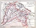
 1947–1955 1970–2010 Location within Pakistan | |
| Area | |
• 1901 | 100,142[1][2] km2 (38,665 sq mi) |
| Population | |
• 1901 | 2,041,534 |
| History | |
• Established | 9 November 1901 |
| 19 April 2010 | |
| Today part of | Pakistan · Khyber Pakhtunkhwa |

_map.gif)

 |
| This article is part of the series |
| Former administrative units of Pakistan |
|---|
The North-West Frontier Province (NWFP; Pashto: شمال لویدیځ سرحدي ولایت, Urdu: شمال مغربی سرحدی صوبہ) was a Chief Commissioner's Province of British India, established on 9 November 1901 from the north-western districts of the Punjab Province. Following the referendum in 1947 to join either Pakistan or India, the province voted hugely in favour of joining Pakistan and it acceded accordingly on 14th August, 1947. It was dissolved to form a unified province of West Pakistan in 1955 upon creation of One Unit Scheme and was re-established in 1970. It was known by this name until 19 April 2010, when it was redesignated as the province of Khyber Pakhtunkhwa following the passing of the Eighteenth Amendment to the Constitution of Pakistan by erstwhile President Asif Ali Zardari.
The province covered an area of 70,709 km2 (27,301 sq mi), including much of the current Khyber Pakhtunkhwa province but excluding the Federally Administered Tribal Areas and the former princely states of Amb, Chitral, Dir, Phulra and Swat. Its capital was the city of Peshawar, and the province was composed of six divisions (Bannu, Dera Ismail Khan, Hazara, Kohat, Mardan, and Peshawar Division; Malakand was later added as the seventh division). Until 1947, the province was bordered by five princely states to the north, the minor states of the Gilgit Agency to the northeast, the province of West Punjab to the east and the province of Balochistan to the south. The Kingdom of Afghanistan lay to the northwest, with the Federally Administered Tribal Areas forming a buffer zone between the two.
History
Formation
The northwestern frontier areas were annexed by the East India Company after the Second Sikh War (1848–49). The territories thenceforth formed a part of Punjab until the province, then known as North-West Frontier Province, was created in 1901 from the north-western districts of the Punjab Province.[3] This region, along with the 'Frontier Tribal Areas', acted as a buffer zone with Afghanistan.
-
 The Punjab in 1880 (included areas of the later North-West Frontier Province)
 -
 Map of the North-West Frontier Province and Kashmir from The Imperial Gazetteer of India (1907-1909)
 -
 Mao of the North-West Frontier Province and neighbouring regions (National Geographic, 1946)

.jpg)

Inside Pakistan
Before the Partition of India, the 1947 North-West Frontier Province referendum was held in July 1947 to decide the future of NWFP, in which the people of the province decided in favor of joining Pakistan. However, the then Chief Minister Dr Khan Sahib, along with his brother Bacha Khan and the Khudai Khidmatgars, boycotted the referendum, citing that it did not have the options of the NWFP becoming independent or joining Afghanistan.[4][5]
As a separate province, the NWFP lasted until 1955 when it was merged into the new province of West Pakistan, under the One Unit policy announced by Prime Minister Chaudhry Mohammad Ali. It was recreated after the dissolution of the One Unit system and lasted under its old nomenclature until April 2010, when it was renamed as the 'Khyber Pakhtunkhwa' province.
Government
The offices of Governor and Chief Minister of the North-West Frontier Province lasted until 14 October 1955.
| Tenure | Governors of the North-West Frontier Province[6] |
|---|---|
| 14 August 1947 – 8 April 1948 | Sir George Cunningham |
| 8 April 1948 – 16 July 1949 | Sir Ambrose Dundas Flux Dundas |
| 16 July 1949 – 14 January 1950 | Sahibzada Mohammad Kursheed |
| 14 January 1950 – 21 February 1950 | Mohammad Ibrahim Khan Jhagra (acting) |
| 21 February 1950 – 23 November 1951 | Ismail Ibrahim Chundrigar |
| 24 November 1951 – 17 November 1954 | Khwaja Shahabuddin |
| 17 November 1954 – 14 October 1955 | Qurban Ali Khan |
| 14 October 1955 | North-West Frontier Province dissolved |
| Tenure | Chief Ministers of the North-West Frontier Province[6] | Political party |
|---|---|---|
| 1 April 1937 – 7 September 1937 | Sir Sahibzada Abdul Qayyum Khan | Non-party government nominee |
| 7 September 1937 – 10 November 1939 | Khan Abdul Jabbar Khan (1st time) | Indian National Congress |
| 10 November 1939 – 25 May 1943 | Governor's rule | |
| 25 May 1943 – 16 March 1945 | Sardar Aurangzeb Khan | Muslim League |
| 16 March 1945 – 22 August 1947 | Khan Abdul Jabbar Khan (2nd time) | Indian National Congress |
| 14 August 1947 | Independence of Pakistan | |
| 23 August 1947 – 23 April 1953 | Abdul Qayyum Khan Kashmiri | Pakistan Muslim League |
| 23 April 1953 – 18 July 1955 | Sardar Abdur Rashid Khan | |
| 19 July 1955 – 14 October 1955 | Sardar Bahadur Khan | |
Demographics
| Year | Pop. | ±% |
|---|---|---|
| 1855 | 1,144,047 | — |
| 1868 | 1,339,566 | +17.1% |
| 1881 | 1,575,943 | +17.6% |
| 1891 | 1,857,519 | +17.9% |
| 1901 | 2,041,534 | +9.9% |
| 1911 | 2,196,933 | +7.6% |
| 1921 | 2,251,340 | +2.5% |
| 1931 | 2,425,076 | +7.7% |
| 1941 | 3,038,067 | +25.3% |
| Source: Census of India [7]: 30 [8] | ||
Historical population and religious counts in North-West Frontier Province were taken in all districts (Hazara, Mardan, Peshawar, Kohat, Bannu, and Dera Ismail Khan), and also included small Trans-Frontier Posts in the Agencies and Tribal Areas.
At independence, there was a clear Muslim Pashtun majority in the North-West Frontier Province, although there were also Hindu and Sikh Pashtun, Hindkowan and Punjabi minorities scattered across the province.
Language
The languages of the North-West Frontier Province included Pashto, Hindko, Kohistani and others, although most of the population spoke Pashto. Prior to the arrival of the British, the official language, for governmental uses and such, was Persian.
Religion
| Religion | Population (1881) |
% (1881) |
Population (1891) |
% (1891) |
Population (1901) |
% (1901) |
Population (1911) |
% (1911) |
Population (1941) |
% (1941) |
|---|---|---|---|---|---|---|---|---|---|---|
| Islam |
1,451,444 | 92.1% | 1,714,490 | 92.3% | 1,882,294 | 92.2% | 2,039,894 | 92.86% | 2,788,797 | 92.52% |
| Hinduism |
111,892 | 7.1% | 118,881 | 6.4% | 128,617 | 6.3% | 119,942 | 5.46% | 180,321 | 5.94% |
| Sikhism |
7,880 | 0.5% | 18,575 | 1% | 26,540 | 1.3% | 30,345 | 1.38% | 57,939 | 1.91% |
| Christianity |
4,728 | 0.3% | 5,573 | 0.3% | 6,125 | 0.3% | 6,585 | 0.3% | 10,889 | 0.36% |
| Others | N/A | N/A | N/A | N/A | N/A | N/A | N/A | N/A | 121 [a] | 0% |
| Total Population | 1,575,943 | 100% | 1,857,519 | 100% | 2,041,534 | 100% | 2,196,766 | 100% | 3,038,087 | 100% |
See also
- Frontier Regions
- Federally Administered Tribal Areas
- Eighteenth Amendment to the Constitution of Pakistan
Notes
References
- ^ Area with Native States in 1901. Province area excluding Native States was 34 169 km2 (13 193 sq mi).
- ^ The Imperial Gazetteer of India 1908, p. 46.
- ^ "Khyber Pakhtunkhwa | province, Pakistan". Encyclopedia Britannica. Retrieved 9 July 2020.
- ^ Meyer, Karl E. (5 August 2008). The Dust of Empire: The Race For Mastery in the Asian Heartland – Karl E. Meyer – Google Boeken. ISBN 9780786724819. Retrieved 10 July 2013.
- ^ "Was Jinnah democratic? – II". Daily Times. 25 December 2011. Retrieved 24 February 2019.
- ^ a b Ben Cahoon, WorldStatesmen.org. "Pakistan Provinces". Retrieved 3 October 2007.
- ^ a b "CENSUS OF INDIA, 1911 VOLUME XII NORTH-WEST FRONTIER PROVINCE" (PDF). Retrieved 23 September 2021.
- ^ a b "CENSUS OF INDIA, 1941 VOLUME X NORTH-WEST FRONTIER PROVINCE". Retrieved 23 September 2021.
References
- The Imperial Gazetteer of India (26 vol, 1908–31), a highly detailed description of all of India in 1901. online edition
External links