
Schenley Bridge
Schenley Bridge | |
|---|---|
 Schenley Bridge, as viewed from South Oakland. | |
| Coordinates | 40°26′29″N 79°56′57″W / 40.4413°N 79.9492°W |
| Locale | Pittsburgh, Pennsylvania |
| Type | Structure |
| Designated | July 26, 2002[1] |
| Designated | 2001 |
| Location | |
 | |
Schenley Bridge connects Schenley Plaza to Schenley Park in Pittsburgh, Pennsylvania. It carries Schenley Drive (between The Carnegie Institute and The Henry Clay Frick Fine Arts Building) over Junction Hollow to Frew Street and Flagstaff Hill.
This bridge in the city's Oakland district is one element of a grand main entrance into the park. Its span is 620 feet and it arches 120 feet above the hollow. Erected in 1897, it replaced a temporary structure by the same name dating from 1890, a year after the park opened.
In 1890, the year after the City of Pittsburgh received the land for Schenley Park, a temporary trestle was constructed across Junction Hollow. The present Schenley Bridge replaced this structure in 1897. One of the original plans was to remove the temporary trestle and re-erect it over Panther Hollow. It has been speculated that the fire which destroyed the Schenley Park Casino near the temporary bridge was also a factor leading to the erection of a wholly new bridge at Panther Hollow. As built, the Schenley Bridge and the Panther Hollow Bridge are near twins—built concurrently.
Schenley Bridge in popular culture

Schenley Bridge and a boiler plant dubbed the Cloud Factory, sited just northeast of the bridge's Oakland abutment, play a special role in The Mysteries of Pittsburgh, the 1988 debut novel by the Pulitzer Prize-winning writer Michael Chabon.
Recently, several love padlocks have started appearing on the bridge.
Gallery
-
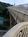 View of Schenley Bridge from one of its outlooks
 -
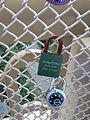 Close-up of one of the lovelocks


References
- ^ "Local Historic Designations". Pittsburgh: Pittsburgh History & Landmarks Foundation. Archived from the original on 21 July 2011. Retrieved 2011-08-11.
{{cite web}}: Unknown parameter|deadurl=ignored (|url-status=suggested) (help)
- Kidney, Walter C. (1997). Pittsburgh's Landmark Architecture: The Historic Buildings of Pittsburgh and Allegheny County. Pittsburgh: Pittsburgh History & Landmarks Foundation. ISBN 0-916670-18-X.
- Toker, Franklin (1994) [1986]. Pittsburgh: An Urban Portrait. Pittsburgh: University of Pittsburgh Press. ISBN 0-8229-5434-6.
External links
- Schenley Bridge (1897) at pghbridges.com
- Schenley Bridge (1890) at pghbridges.com
- Schenley Park website
- Bridges of Schenley Park

| Government |  | |
|---|---|---|
| Economy | ||
| Other topics | ||
40°26′29″N 79°56′57″W / 40.4413°N 79.9492°W
This article related to a building or structure in Pittsburgh is a stub. You can help Wikipedia by expanding it. |
This article about a bridge in Pennsylvania is a stub. You can help Wikipedia by expanding it. |
- Bridges in Pittsburgh
- Bridges in Pittsburgh, Pennsylvania
- Bridges completed in 1890
- Bridges completed in 1897
- Parks in Pittsburgh, Pennsylvania
- City of Pittsburgh historic designations
- Pittsburgh History & Landmarks Foundation Historic Landmarks
- Road bridges in Pennsylvania
- Schenley Park
- Pittsburgh building and structure stubs
- Pennsylvania bridge (structure) stubs