Sierra Bullones
Sierra Bullones | |
|---|---|
 Sierra Bullones, Bohol | |
| Nickname: Golden Town of Bohol | |
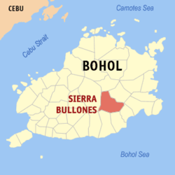
 Map of Bohol with Sierra Bullones highlighted | |
| Coordinates: 9°49′N 124°17′E / 9.82°N 124.28°E | |
| Country | Philippines |
| Region | Central Visayas (Region VII) |
| Province | Bohol |
| District | 3rd district of Bohol |
| Founded | January 5, 18635 January 1863 |
| Barangay | Template:PH barangay parts |
| Government | |
| • Type | Sangguniang Bayan |
| • Mayor | Simplicio Maestrado (LP) |
| • Vice mayor | Rainfredo Buslon |
| • Municipal Council | Members |
| • Representative | Arthur Yap |
| Area | |
| • Total | 198.87 km2 (76.78 sq mi) |
| Population (2020 census)[3] | |
| • Total | 26,095 |
| • Density | 130/km2 (340/sq mi) |
| • Voter (2022)[4] | 17,853 |
| • Language | Boholano dialect Cebuano Eskayan Tagalog |
| Time zone | UTC+8 (PST) |
| ZIP code | 6320 |
| IDD : area code | +63 (0)38 |
| Income class | 3rd class |
| PSGC | 071240000 |
Sierra Bullones is a [[Template:PH plural of the Philippines#Income classification|3rd municipal income class municipality]] in the province of Bohol, Philippines, 71 kilometres (44 mi) from Tagbilaran. According to the 2020 census, it has a population of 26,095.[3] Template:PH electorate
Barangays
Sierra Bullones comprises 22 barangays:
| PSGC | Barangay | Population | ±% p.a. | |||
|---|---|---|---|---|---|---|
| 2020[3] | 2010[5] | |||||
| 071240001 | Abachanan | 7.7% | 2,018 | 1,999 | 0.09% | |
| 071240002 | Anibongan | 2.7% | 698 | 707 | −0.13% | |
| 071240003 | Bugsoc | 9.7% | 2,542 | 2,583 | −0.16% | |
| 071240009 | Cahayag | 1.8% | 479 | 489 | −0.21% | |
| 071240004 | Canlangit | 5.5% | 1,423 | 1,390 | 0.23% | |
| 071240005 | Canta‑ub | 1.4% | 373 | 314 | 1.74% | |
| 071240006 | Casilay | 1.5% | 385 | 407 | −0.55% | |
| 071240007 | Danicop | 3.6% | 946 | 981 | −0.36% | |
| 071240008 | Dusita | 2.4% | 621 | 598 | 0.38% | |
| 071240010 | La Union | 2.5% | 644 | 620 | 0.38% | |
| 071240011 | Lataban | 2.3% | 597 | 512 | 1.55% | |
| 071240012 | Magsaysay | 2.3% | 591 | 580 | 0.19% | |
| 071240014 | Man‑od | 4.3% | 1,134 | 1,072 | 0.56% | |
| 071240013 | Matin‑ao | 5.0% | 1,304 | 1,356 | −0.39% | |
| 071240015 | Poblacion | 10.7% | 2,782 | 2,763 | 0.07% | |
| 071240016 | Salvador | 6.7% | 1,741 | 1,716 | 0.14% | |
| 071240017 | San Agustin | 4.2% | 1,083 | 1,192 | −0.95% | |
| 071240018 | San Isidro | 5.3% | 1,387 | 1,419 | −0.23% | |
| 071240019 | San Jose | 3.4% | 888 | 879 | 0.10% | |
| 071240020 | San Juan | 3.7% | 960 | 979 | −0.20% | |
| 071240021 | Santa Cruz | 3.5% | 924 | 940 | −0.17% | |
| 071240022 | Villa Garcia | 4.7% | 1,225 | 1,202 | 0.19% | |
| Total | 26,095 | 24,698 | 0.55% | |||
Demographics
|
| ||||||||||||||||||||||||||||||||||||||||||||||||
| Source: Philippine Statistics Authority[6][5][7][8] | |||||||||||||||||||||||||||||||||||||||||||||||||
Gallery
-
Paradise Hills Resort, Sierra Bullones
-
Rice terraces in the hills of Sierra Bullones
References
- ^ Municipality of Sierra Bullones | (DILG)
- ^ "Municipal: Sierra Bullones". PSGC Interactive. Quezon City, Philippines: Philippine Statistics Authority. Retrieved 8 January 2016.
- ^ a b c Census of Population (2020). "Region VII (Central Visayas)". Total Population by Province, City, Municipality and Barangay. Philippine Statistics Authority. Retrieved 8 July 2021.
- ^ "Number of Registered Voters by Sex : 2019 National and Local Elections" (PDF). Commission on Elections. 2019.
- ^ a b Census of Population and Housing (2010). "Region VII (Central Visayas)" (PDF). Total Population by Province, City, Municipality and Barangay. National Statistics Office. Retrieved 29 June 2016.
- ^ Census of Population (2015). "Region VII (Central Visayas)". Total Population by Province, City, Municipality and Barangay. Philippine Statistics Authority. Retrieved 20 June 2016.
- ^ Censuses of Population (1903–2007). "Region VII (Central Visayas)". Table 1. Population Enumerated in Various Censuses by Province/Highly Urbanized City: 1903 to 2007. National Statistics Office.
{{cite encyclopedia}}: CS1 maint: numeric names: authors list (link) - ^ "Province of Bohol". Municipality Population Data. Local Water Utilities Administration Research Division. Retrieved 17 December 2016.
External links
Wikimedia Commons has media related to Sierra Bullones.


