
Skjervøy
Skjervøy Municipality
Skjervøy kommune | |
|---|---|
| Skjervø herred (historic name) | |
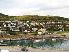
 View of the village of Årviksand | |
 Flag | |
 Troms within Norway | |
 Skjervøy within Troms | |
| Coordinates: 70°05′07″N 20°39′34″E / 70.08528°N 20.65944°E | |
| Country | Norway |
| County | Troms |
| District | Nord-Troms |
| Established | 1 Jan 1838 |
| • Created as | Formannskapsdistrikt |
| Administrative centre | Skjervøy |
| Government | |
| • Mayor (2015) | Ørjan Albrigtsen (KrF/Kp) |
| Area | |
| • Total | 473.94 km2 (182.99 sq mi) |
| • Land | 465.33 km2 (179.66 sq mi) |
| • Water | 8.67 km2 (3.35 sq mi) 1.8% |
| • Rank | #212 in Norway |
| Population (2023) | |
| • Total | 2,790 |
| • Rank | #239 in Norway |
| • Density | 6/km2 (20/sq mi) |
| • Change (10 years) | |
| Demonym | Skjervøyværing[1] |
| Official language | |
| • Norwegian form | Bokmål |
| Time zone | UTC+01:00 (CET) |
| • Summer (DST) | UTC+02:00 (CEST) |
| ISO 3166 code | NO-5542[3] |
| Website | Official website |

Skjervøy kommune (Northern Sami: Skiervvá suohkan; Kven: Kieruan komuuni) is a municipality in Troms county, Norway. The administrative centre of the municipality is the town of Skjervøy on the island of Skjervøya, where most of the inhabitants live. The main industries are fishing and shipbuilding.
The 474-square-kilometre (183 sq mi) municipality is the 212th largest by area out of the 356 municipalities in Norway. Skjervøy is the 239th most populous municipality in Norway with a population of 2,790. The municipality's population density is 6 inhabitants per square kilometre (16/sq mi) and its population has decreased by 4% over the previous 10-year period.[4][5]
General information[edit]
The municipality of Skjervøe (later spelled Skjervøy) was established on 1 January 1838 (see formannskapsdistrikt law). In 1863, the southeastern (inland) part of the municipality (population: 1,677) was separated to form the new Kvænangen Municipality. This left 2,785 people in Skjervøy. Then on 1 January 1886 the southern part of the municipality (population: 1,057) was separated from Skjervøy to form the new Nordreisa Municipality. This left 2,096 inhabitants in Skjervøy.
On 1 January 1890, the Trætten and Loppevolden farms (population: 32) were transferred from Skjervøy to Nordreisa. On 1 January 1965, the Meilands area (population: 12) was transferred to Kvænangen. On 1 January 1972, the parts of Skjervøy lying on the mainland (population: 1,556) were transferred from Skjervøy to Nordreisa, and the uninhabited Mannskarvik farm was transferred to Kvænangen. Then on 1 January 1982 the southern part of the island of Uløya (population: 128) was transferred from Skjervøy to Nordreisa.[6]
On 1 January 2020, the municipality became part of the newly formed Troms og Finnmark county. Previously, it had been part of the old Troms county.[7] On 1 January 2024, the Troms og Finnmark county was divided and the municipality once again became part of Troms county.[8]
Name[edit]
The municipality (originally the parish) is named after the small island of Skjervøya (Old Norse: Skerføy) since the first Skjervøy Church was built there. The first element is skerf which means "rocky ground". The last element is øy which means "island".[9] Historically, the name of the municipality was spelled Skjervøe or Skjervø. On 6 January 1908, a royal resolution changed the spelling of the name of the municipality to Skjervøy.[10]
Coat of arms[edit]
The coat of arms was granted on 27 March 1987. The official blazon is "Argent, a cormorant head erased sable" (Norwegian: I sølv et svart skarvehode). This means the arms have a field (background) with a tincture of argent which means it is commonly colored white, but if it is made out of metal, then silver is used. The charge is the head of a cormorant which has a tincture of sable. The arms are partly canting since the Norwegian word skarf means cormorant and that word is similar to the name Skjervøy. The cormorant also symbolizes the coastal municipality, which (like the bird) is dependent on fishing for its living. The cormorant is also a common bird in the area. The arms were designed by Kåre Bondesen and Jan Roald Andreassen.[11][12][13]
Churches[edit]
The Church of Norway has one parish (sokn) within the municipality of Skjervøy. It is part of the Nord-Troms prosti (deanery) in the Diocese of Nord-Hålogaland.
| Parish (sokn) | Church name | Location of the church | Year built |
|---|---|---|---|
| Skjervøy | Arnøy Church | Arnøyhamn | 1978 |
| Skjervøy Church | Skjervøy | 1728 |
History[edit]
Skjervøy Church dates back to 1728 and it is the oldest wooden church in Troms county. The village of Maursund is an old trading post with well-preserved 19th-century houses.
Government[edit]
All municipalities in Norway are responsible for primary education (through 10th grade), outpatient health services, senior citizen services, welfare and other social services, zoning, economic development, and municipal roads and utilities. The municipality is governed by a municipal council of directly elected representatives. The mayor is indirectly elected by a vote of the municipal council.[14] The municipality is under the jurisdiction of the Nord-Troms og Senja District Court and the Hålogaland Court of Appeal.
Municipal council[edit]
The municipal council (Kommunestyre) of Skjervøy is made up of 19 representatives that are elected to four year terms. The tables below show the current and historical composition of the council by political party.
| Party name (in Norwegian) | Number of representatives | |
|---|---|---|
| Labour Party (Arbeiderpartiet) | 2 | |
| Progress Party (Fremskrittspartiet) | 5 | |
| Conservative Party (Høyre) | 1 | |
| Christian Democratic Party (Kristelig Folkeparti) | 6 | |
| Red Party (Rødt) | 1 | |
| Centre Party (Senterpartiet) | 3 | |
| Socialist Left Party (Sosialistisk Venstreparti) | 1 | |
| Total number of members: | 19 | |
| Party name (in Norwegian) | Number of representatives | |
|---|---|---|
| Labour Party (Arbeiderpartiet) | 2 | |
| Progress Party (Fremskrittspartiet) | 3 | |
| Conservative Party (Høyre) | 1 | |
| Christian Democratic Party (Kristelig Folkeparti) | 6 | |
| Centre Party (Senterpartiet) | 5 | |
| Joint list of the Red Party (Rødt) and the Socialist Left Party (Sosialistisk Venstreparti) | 2 | |
| Total number of members: | 19 | |
| Party name (in Norwegian) | Number of representatives | |
|---|---|---|
| Labour Party (Arbeiderpartiet) | 4 | |
| Progress Party (Fremskrittspartiet) | 3 | |
| Conservative Party (Høyre) | 1 | |
| Centre Party (Senterpartiet) | 4 | |
| Socialist Left Party (Sosialistisk Venstreparti) | 2 | |
| Joint list of the Christian Democratic Party (Kristelig Folkeparti) and the Coastal Party (Kystpartiet) | 5 | |
| Total number of members: | 19 | |
| Party name (in Norwegian) | Number of representatives | |
|---|---|---|
| Labour Party (Arbeiderpartiet) | 3 | |
| Progress Party (Fremskrittspartiet) | 2 | |
| Conservative Party (Høyre) | 2 | |
| Christian Democratic Party (Kristelig Folkeparti) | 1 | |
| Coastal Party (Kystpartiet) | 7 | |
| Centre Party (Senterpartiet) | 2 | |
| Socialist Left Party (Sosialistisk Venstreparti) | 2 | |
| Total number of members: | 19 | |
| Party name (in Norwegian) | Number of representatives | |
|---|---|---|
| Labour Party (Arbeiderpartiet) | 3 | |
| Progress Party (Fremskrittspartiet) | 3 | |
| Conservative Party (Høyre) | 1 | |
| Christian Democratic Party (Kristelig Folkeparti) | 1 | |
| Coastal Party (Kystpartiet) | 7 | |
| Centre Party (Senterpartiet) | 2 | |
| Socialist Left Party (Sosialistisk Venstreparti) | 2 | |
| Total number of members: | 19 | |
| Party name (in Norwegian) | Number of representatives | |
|---|---|---|
| Labour Party (Arbeiderpartiet) | 4 | |
| Progress Party (Fremskrittspartiet) | 2 | |
| Conservative Party (Høyre) | 1 | |
| Christian Democratic Party (Kristelig Folkeparti) | 7 | |
| Centre Party (Senterpartiet) | 2 | |
| Socialist Left Party (Sosialistisk Venstreparti) | 3 | |
| Total number of members: | 19 | |
| Party name (in Norwegian) | Number of representatives | |
|---|---|---|
| Labour Party (Arbeiderpartiet) | 4 | |
| Conservative Party (Høyre) | 3 | |
| Christian Democratic Party (Kristelig Folkeparti) | 14 | |
| Centre Party (Senterpartiet) | 1 | |
| Socialist Left Party (Sosialistisk Venstreparti) | 3 | |
| Total number of members: | 25 | |
| Party name (in Norwegian) | Number of representatives | |
|---|---|---|
| Labour Party (Arbeiderpartiet) | 12 | |
| Conservative Party (Høyre) | 9 | |
| Christian Democratic Party (Kristelig Folkeparti) | 6 | |
| Centre Party (Senterpartiet) | 2 | |
| Socialist Left Party (Sosialistisk Venstreparti) | 3 | |
| Total number of members: | 25 | |
| Party name (in Norwegian) | Number of representatives | |
|---|---|---|
| Labour Party (Arbeiderpartiet) | 5 | |
| Conservative Party (Høyre) | 8 | |
| Christian Democratic Party (Kristelig Folkeparti) | 5 | |
| Centre Party (Senterpartiet) | 3 | |
| Socialist Left Party (Sosialistisk Venstreparti) | 4 | |
| Total number of members: | 25 | |
| Party name (in Norwegian) | Number of representatives | |
|---|---|---|
| Labour Party (Arbeiderpartiet) | 9 | |
| Conservative Party (Høyre) | 6 | |
| Christian Democratic Party (Kristelig Folkeparti) | 4 | |
| Centre Party (Senterpartiet) | 2 | |
| Socialist Left Party (Sosialistisk Venstreparti) | 2 | |
| Liberal Party (Venstre) | 2 | |
| Total number of members: | 25 | |
| Party name (in Norwegian) | Number of representatives | |
|---|---|---|
| Labour Party (Arbeiderpartiet) | 11 | |
| Conservative Party (Høyre) | 6 | |
| Christian Democratic Party (Kristelig Folkeparti) | 4 | |
| Centre Party (Senterpartiet) | 2 | |
| Socialist Left Party (Sosialistisk Venstreparti) | 1 | |
| Liberal Party (Venstre) | 1 | |
| Total number of members: | 25 | |
| Party name (in Norwegian) | Number of representatives | |
|---|---|---|
| Labour Party (Arbeiderpartiet) | 9 | |
| Conservative Party (Høyre) | 4 | |
| Christian Democratic Party (Kristelig Folkeparti) | 4 | |
| Centre Party (Senterpartiet) | 3 | |
| Socialist Left Party (Sosialistisk Venstreparti) | 1 | |
| Liberal Party (Venstre) | 4 | |
| Total number of members: | 25 | |
| Party name (in Norwegian) | Number of representatives | |
|---|---|---|
| Labour Party (Arbeiderpartiet) | 11 | |
| Conservative Party (Høyre) | 2 | |
| Christian Democratic Party (Kristelig Folkeparti) | 4 | |
| Centre Party (Senterpartiet) | 4 | |
| Socialist Left Party (Sosialistisk Venstreparti) | 1 | |
| Liberal Party (Venstre) | 3 | |
| Total number of members: | 25 | |
| Party name (in Norwegian) | Number of representatives | |
|---|---|---|
| Labour Party (Arbeiderpartiet) | 13 | |
| Conservative Party (Høyre) | 2 | |
| Centre Party (Senterpartiet) | 5 | |
| Liberal Party (Venstre) | 5 | |
| Total number of members: | 25 | |
| Party name (in Norwegian) | Number of representatives | |
|---|---|---|
| Labour Party (Arbeiderpartiet) | 18 | |
| Conservative Party (Høyre) | 3 | |
| Socialist People's Party (Sosialistisk Folkeparti) | 1 | |
| Liberal Party (Venstre) | 7 | |
| Local List(s) (Lokale lister) | 2 | |
| Total number of members: | 31 | |
| Party name (in Norwegian) | Number of representatives | |
|---|---|---|
| Labour Party (Arbeiderpartiet) | 17 | |
| Conservative Party (Høyre) | 4 | |
| List of workers, fishermen, and small farmholders (Arbeidere, fiskere, småbrukere liste) | 4 | |
| Joint List(s) of Non-Socialist Parties (Borgerlige Felleslister) | 6 | |
| Total number of members: | 31 | |
| Party name (in Norwegian) | Number of representatives | |
|---|---|---|
| Labour Party (Arbeiderpartiet) | 16 | |
| Communist Party (Kommunistiske Parti) | 2 | |
| List of workers, fishermen, and small farmholders (Arbeidere, fiskere, småbrukere liste) | 7 | |
| Joint List(s) of Non-Socialist Parties (Borgerlige Felleslister) | 6 | |
| Total number of members: | 31 | |
| Party name (in Norwegian) | Number of representatives | |
|---|---|---|
| Labour Party (Arbeiderpartiet) | 16 | |
| Communist Party (Kommunistiske Parti) | 2 | |
| List of workers, fishermen, and small farmholders (Arbeidere, fiskere, småbrukere liste) | 9 | |
| Joint List(s) of Non-Socialist Parties (Borgerlige Felleslister) | 4 | |
| Total number of members: | 31 | |
| Party name (in Norwegian) | Number of representatives | |
|---|---|---|
| Labour Party (Arbeiderpartiet) | 12 | |
| Joint List(s) of Non-Socialist Parties (Borgerlige Felleslister) | 2 | |
| Local List(s) (Lokale lister) | 6 | |
| Total number of members: | 20 | |
| Party name (in Norwegian) | Number of representatives | |
|---|---|---|
| Labour Party (Arbeiderpartiet) | 12 | |
| Joint List(s) of Non-Socialist Parties (Borgerlige Felleslister) | 7 | |
| Local List(s) (Lokale lister) | 1 | |
| Total number of members: | 20 | |
| Party name (in Norwegian) | Number of representatives | |
|---|---|---|
| Labour Party (Arbeiderpartiet) | 13 | |
| Local List(s) (Lokale lister) | 7 | |
| Total number of members: | 20 | |
| Party name (in Norwegian) | Number of representatives | |
|---|---|---|
| Labour Party (Arbeiderpartiet) | 9 | |
| List of workers, fishermen, and small farmholders (Arbeidere, fiskere, småbrukere liste) | 9 | |
| Local List(s) (Lokale lister) | 2 | |
| Total number of members: | 20 | |
| Note: Due to the German occupation of Norway during World War II, no elections were held for new municipal councils until after the war ended in 1945. | ||
Mayors[edit]
- 1837–1838: Jens Schmidt
- 1839–1840: Peder Borch Lund
- 1841–1853: Samuel Bugge Giæver
- 1854–1858: Andreas Qvale
- 1859–1860: Peder Borch Lund
- 1861–1866: Andreas Qvale
- 1867–1868: Simon Kildal Giæver
- 1869–1872: Christian Magelssen
- 1873–1874: Bendiks Bæverdahl
- 1875–1878: Christian Magelssen
- 1879–1880: Johannes Holmboe Giæver
- 1881–1892: John Hagen (V)
- 1893–1894: Ivar Lund
- 1895–1896: Peder Martin Blyth Daae
- 1897–1901: Johan Georgsen
- 1902–1913: Marcelius Hansen (V)
- 1914–1922: Thorvald Hoseth Giæver
- 1923–1925: Marcelius Hansen (V)
- 1926–1941: Rønning Østgaard (Bp)
- 1945-1945: Nils Jacobsen
- 1945-1945: Peder Rasmus Dyrkoren
- 1945-1945: Thorvald Hoseth Giæver
- 1946–1963: Lars Hallen (Ap)
- 1964–1971: John Steffensen (Ap)
- 1972–1982: Aksel Jørgensen (V)
- 1983–1995: Kurt Leif Strøm (H)
- 1995–2011: Roy Waage (KrF/K)
- 2011–2015: Torgeir Johnsen (K/Sp)
- 2015–present: Ørjan Albrigtsen (KrF)
Geography[edit]
The island municipality is surrounded by the Norwegian Sea to the north, Ullsfjorden to the west, Lyngenfjorden to the southwest, Reisafjorden to the southeast, and Kvænangen fjord to the east. The municipality consists of several islands, the major one being Arnøya, with the villages of Årviksand, Akkarvik, and Arnøyhamn. Most people, however, live on the relatively small island of Skjervøya, where more than 2,316 people live in the central village of Skjervøy with its sheltered harbour.[35] The other islands include Haukøya, Kågen, Laukøya, Vorterøya, and the northern half of Uløya. Kågen and Skjervøya are connected by the Skjervøy Bridge. Kågen is connected to the mainland by the Maursund Tunnel.
Climate[edit]
Skjervøy has continental subarctic climate. The Köppen Climate Classification subtype for this climate is "Dfc". The Norwegian Meteorological Institute has been operating a weather station in Skjervøy since 1936.[36][37]
| Month | Jan | Feb | Mar | Apr | May | Jun | Jul | Aug | Sep | Oct | Nov | Dec | Year |
|---|---|---|---|---|---|---|---|---|---|---|---|---|---|
| Mean daily maximum °C (°F) | −1 (30) |
−1 (30) |
1 (34) |
4 (39) |
8 (46) |
12 (54) |
15 (59) |
14 (57) |
11 (52) |
6 (43) |
2 (36) |
0 (32) |
6 (43) |
| Daily mean °C (°F) | −4 (25) |
−4 (25) |
−2 (28) |
1 (34) |
6 (43) |
9 (48) |
12 (54) |
12 (54) |
8 (46) |
4 (39) |
0 (32) |
−2 (28) |
3 (38) |
| Mean daily minimum °C (°F) | −7 (19) |
−6 (21) |
−4 (25) |
−1 (30) |
3 (37) |
7 (45) |
9 (48) |
8 (46) |
5 (41) |
1 (34) |
−3 (27) |
−5 (23) |
1 (33) |
| Average rainfall mm (inches) | 25.7 (1.01) |
25.1 (0.99) |
25.7 (1.01) |
30 (1.2) |
42.5 (1.67) |
52.8 (2.08) |
61 (2.4) |
56 (2.2) |
63.5 (2.50) |
71.2 (2.80) |
42.2 (1.66) |
32.6 (1.28) |
528.3 (20.8) |
| Average snowfall mm (inches) | 330 (13.0) |
327 (12.9) |
214 (8.4) |
120 (4.7) |
12 (0.5) |
0 (0) |
0 (0) |
0 (0) |
1 (0.0) |
71 (2.8) |
210 (8.3) |
311 (12.2) |
1,596 (62.8) |
| Average precipitation days (≥ 1 mm) | 11.4 | 10.5 | 9.9 | 9.3 | 9.3 | 9.4 | 9.8 | 9.7 | 11.2 | 13.7 | 11.5 | 12.7 | 128.4 |
| Average rainy days (≥ 1 mm) | 3.1 | 2.8 | 3.8 | 5.9 | 8.9 | 9.4 | 9.8 | 9.7 | 11.1 | 11.1 | 5.6 | 4.2 | 85.4 |
| Average snowy days (≥ 1 mm) | 5.1 | 4.7 | 3.7 | 2 | .1 | 0 | 0 | 0 | 0 | 1 | 3.1 | 5.1 | 24.8 |
| Mean daily daylight hours | 1.5 | 7.3 | 11.8 | 16.4 | 22.5 | 24 | 23.7 | 18 | 13.2 | 8.8 | 3.2 | 0 | 12.5 |
| Source 1: WeatherSpark.com[38] | |||||||||||||
| Source 2: Weatherbase.com[39] | |||||||||||||
Transportation[edit]
The Hurtigruten (coastal cruise and cargo ship service) stops at the village of Skjervøy. There is also a scheduled express ferry operated by Boreal Transport Nord AS with intermediate stops between the village of Skjervøy and the city of Tromsø. The undersea Maursund Tunnel connects this island with the mainland to the south. There are also ferry connections between the islands of Arnøya and Laukøya offered by both Boreal Transport Nord AS and Torghatten Nord AS. Sørkjosen Airport offers flights to Tromsø and several destinations in Finnmark.
Notable people[edit]
- Leonhard Seppala (1877 - 1967) Norwegian-Kveni dog musher, brought up in Skjervøy
- Knut Werner Hansen (born 1951 in Skjervøy) a Norwegian politician, county Mayor of Troms
- Hanne Grete Einarsen (born 1966) Norwegian-Sami artist, brought up in Skjervøy
- Odd-Karl Stangnes (born 1968 in Skjervøy) a Norwegian football coach and former player
- Kristina Torbergsen (born 1987 in Skjervøy) a Norwegian politician
- Ørjan "TheViper" Larsen (born 1991 in Skjervøy) a Norwegian Age of Empires II player
Media gallery[edit]
-
 Part of Skjervøy village
 -
 Part of Skjervøy village
 -
 Old photo of Skjervøy Church
 -


References[edit]
- ^ "Navn på steder og personer: Innbyggjarnamn" (in Norwegian). Språkrådet.
- ^ "Forskrift om målvedtak i kommunar og fylkeskommunar" (in Norwegian). Lovdata.no.
- ^ Bolstad, Erik; Thorsnæs, Geir, eds. (26 January 2023). "Kommunenummer". Store norske leksikon (in Norwegian). Kunnskapsforlaget.
- ^ Statistisk sentralbyrå. "Table: 06913: Population 1 January and population changes during the calendar year (M)" (in Norwegian).
- ^ Statistisk sentralbyrå. "09280: Area of land and fresh water (km²) (M)" (in Norwegian).
- ^ Jukvam, Dag (1999). "Historisk oversikt over endringer i kommune- og fylkesinndelingen" (PDF) (in Norwegian). Statistisk sentralbyrå.
- ^ Mæhlum, Lars, ed. (24 December 2019). "Troms og Finnmark". Store norske leksikon (in Norwegian). Kunnskapsforlaget. Retrieved 26 December 2019.
- ^ "Fylkesinndelingen fra 2024" (in Norwegian). Regjeringen.no. 5 July 2022.
- ^ Rygh, Oluf (1911). Norske gaardnavne: Tromsø amt (in Norwegian) (17 ed.). Kristiania, Norge: W. C. Fabritius & sønners bogtrikkeri. p. 176.
- ^ "Norsk Lovtidende. 2den Afdeling. 1908. Samling af Love, Resolutioner m.m". Norsk Lovtidend (in Norwegian). Kristiania, Norge: Grøndahl og Søns Boktrykkeri: 24. 1908.
- ^ "Civic heraldry of Norway - Norske Kommunevåpen". Heraldry of the World. Retrieved 28 January 2023.
- ^ "Skjervøy, Troms (Norway)". Flags of the World. Retrieved 28 January 2023.
- ^ "Godkjenning av våpen og flagg". Lovdata.no (in Norwegian). Norges kommunal- og arbeidsdepartementet. 27 March 1987. Retrieved 28 January 2023.
- ^ Hansen, Tore; Vabo, Signy Irene, eds. (20 September 2022). "kommunestyre". Store norske leksikon (in Norwegian). Kunnskapsforlaget. Retrieved 14 October 2022.
- ^ "Kommunestyrevalg 2023 - Troms Romsa". Valgdirektoratet. Retrieved 6 January 2024.
- ^ "Tall for Norge: Kommunestyrevalg 2019 - Troms og Finnmark". Valg Direktoratet. Retrieved 26 October 2019.
- ^ a b c d "Table: 04813: Members of the local councils, by party/electoral list at the Municipal Council election (M)" (in Norwegian). Statistics Norway.
- ^ "Tall for Norge: Kommunestyrevalg 2011 - Troms Romsa". Valg Direktoratet. Retrieved 26 October 2019.
- ^ "Kommunestyrevalget 1995" (PDF) (in Norwegian). Oslo-Kongsvinger: Statistisk sentralbyrå. 1996. Retrieved 18 March 2020.
- ^ "Kommunestyrevalget 1991" (PDF) (in Norwegian). Oslo-Kongsvinger: Statistisk sentralbyrå. 1993. Retrieved 18 March 2020.
- ^ "Kommunestyrevalget 1987" (PDF) (in Norwegian). Oslo-Kongsvinger: Statistisk sentralbyrå. 1988. Retrieved 18 March 2020.
- ^ "Kommunestyrevalget 1983" (PDF) (in Norwegian). Oslo-Kongsvinger: Statistisk sentralbyrå. 1984. Retrieved 18 March 2020.
- ^ "Kommunestyrevalget 1979" (PDF) (in Norwegian). Oslo: Statistisk sentralbyrå. 1979. Retrieved 18 March 2020.
- ^ "Kommunevalgene 1975" (PDF) (in Norwegian). Oslo: Statistisk sentralbyrå. 1977. Retrieved 18 March 2020.
- ^ "Kommunevalgene 1972" (PDF) (in Norwegian). Oslo: Statistisk sentralbyrå. 1973. Retrieved 18 March 2020.
- ^ "Kommunevalgene 1967" (PDF) (in Norwegian). Oslo: Statistisk sentralbyrå. 1967. Retrieved 18 March 2020.
- ^ "Kommunevalgene 1963" (PDF) (in Norwegian). Oslo: Statistisk sentralbyrå. 1964. Retrieved 18 March 2020.
- ^ "Kommunevalgene og Ordførervalgene 1959" (PDF) (in Norwegian). Oslo: Statistisk sentralbyrå. 1960. Retrieved 18 March 2020.
- ^ "Kommunevalgene og Ordførervalgene 1955" (PDF) (in Norwegian). Oslo: Statistisk sentralbyrå. 1957. Retrieved 18 March 2020.
- ^ "Kommunevalgene og Ordførervalgene 1951" (PDF) (in Norwegian). Oslo: Statistisk sentralbyrå. 1952. Retrieved 18 March 2020.
- ^ "Kommunevalgene og Ordførervalgene 1947" (PDF) (in Norwegian). Oslo: Statistisk sentralbyrå. 1948. Retrieved 18 March 2020.
- ^ "Kommunevalgene og Ordførervalgene 1945" (PDF) (in Norwegian). Oslo: Statistisk sentralbyrå. 1947. Retrieved 18 March 2020.
- ^ "Kommunevalgene og Ordførervalgene 1937" (PDF) (in Norwegian). Oslo: Statistisk sentralbyrå. 1938. Retrieved 18 March 2020.
- ^ Friis, Guttorm (1984). Firma Kåre Renø, Skjervøy, femti år, 1984. Reker og rekeproduksjon. Kirke- og handelsstedet Skjervøy (in Norwegian). Skjervøy: Skjervøy kommune. pp. 118–120.
- ^ Statistisk sentralbyrå (1 January 2012). "Urban settlements. Population and area, by municipality". Archived from the original on 13 November 2012.
- ^ "Climate Summary". Retrieved 26 February 2023.
- ^ "Skjervøy". Yr.no. Norwegian Meteorological Institute. Retrieved 26 February 2023.
- ^ "Climate and Average Weather Year Round". weatherspark.com. Retrieved 25 February 2023.
- ^ "Monthly - Weather averages summary". weatherbase.com. Retrieved 25 February 2023.
External links[edit]
- Municipal fact sheet from Statistics Norway (in Norwegian)
- 41 kg cod caught on fishing rod April 2010 (with pictures) (in Norwegian)
- Visit Tromso January 2018 list of Express Boats and Ferry service for Tromso.
- Boreal Transport Nord Nord AS January 2018 list for ferry routes by ferry operator for Troms county
| |||||||
 | Towns and cities | ||||||
| Municipalities |
| ||||||
| |||||||
| International | |
|---|---|
| National | |
| Geographic | |