South Jeolla Province
34°45′N 127°0′E / 34.750°N 127.000°E Template:Infobox Korean Provinces South Jeolla Province, or Jeollanam-do, is a province in the southwest of South Korea. The province was formed in 1896 from the southern half of the former Jeolla province, remained a province of Korea until the country's division in 1945, then became part of South Korea. Gwangju was the capital of the province, until the provincial office moved to the southern village of Namak, Muan County in 2005.
Geography
The province is part of the Honam region, and is bounded on the west by the Yellow Sea, on the north by Jeollabuk-do Province, on the south by Jeju Strait, and on the east by Gyeongsangnam-do.
There are almost 2,000 islands along the coastline, about three quarters of which are uninhabited. The coastline is about 6,100 kilometres (3,800 mi) long. Some of the marine products, in particular oyster and seaweed cultivation, are leading in South Korea.
The province is only partially mountainous. The plains along the rivers Seomjin, Yeongsan and Tamjin create a large granary. There is abundant rainfall in the area, which helps agriculture. The province is also home to the warmest weather on the peninsula. This helps to produce large amounts of agricultural produce, mainly rice, wheat, barley, pulses and potatoes. Vegetables, cotton and fruits are also grown in the province.
A small amount of gold and coal is mined in the province, but industries have also been developed in the area.
Administrative divisions
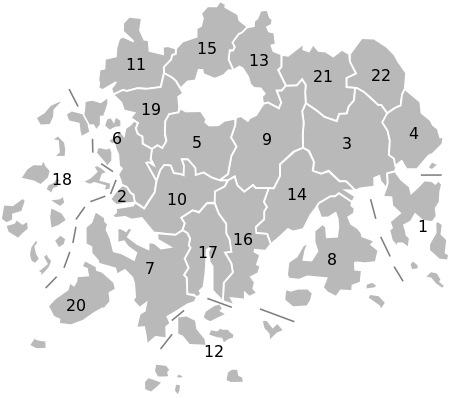
Jeollanam-do is divided into 5 cities (si) and 17 counties (gun). Listed below is the name of each entity in English, hangul, and hanja.
| Map | # | Name | Hangul | Hanja | Population (2010) |
|---|---|---|---|---|---|

| |||||
| — City — | |||||
| 1 | Yeosu | 여수 | 麗水 | 269,937 | |
| 2 | Mokpo | 목포 | 木浦 | 249,960 | |
| 3 | Suncheon | 순천 | 順天 | 258,670 | |
| 4 | Gwangyang | 광양 | 光陽 | 137,810 | |
| 5 | Naju | 나주 | 羅州 | 78,679 | |
| — County — | |||||
| 6 | Muan County | 무안군 | 務安郡 | 68,462 | |
| 7 | Haenam County | 해남군 | 海南郡 | 66,042 | |
| 8 | Goheung County | 고흥군 | 高興郡 | 63,392 | |
| 9 | Hwasun County | 화순군 | 和順郡 | 62,219 | |
| 10 | Yeongam County | 영암군 | 靈巖郡 | 58,748 | |
| 11 | Yeonggwang County | 영광군 | 靈光郡 | 48,663 | |
| 12 | Wando County | 완도군 | 莞島郡 | 46,777 | |
| 13 | Damyang County | 담양군 | 潭陽郡 | 41,027 | |
| 14 | Boseong County | 보성군 | 寶城郡 | 40,166 | |
| 15 | Jangseong County | 장성군 | 長城郡 | 38,507 | |
| 16 | Jangheung County | 장흥군 | 長興郡 | 35,763 | |
| 17 | Gangjin County | 강진군 | 康津郡 | 34,204 | |
| 18 | Sinan County | 신안군 | 新安郡 | 33,222 | |
| 19 | Hampyeong County | 함평군 | 咸平郡 | 30,995 | |
| 20 | Jindo County | 진도군 | 珍島郡 | 28,565 | |
| 21 | Gokseong County | 곡성군 | 谷城郡 | 27,272 | |
| 22 | Gurye County | 구례군 | 求禮郡 | 22,419 | |
Sister cities and provinces
 Gyeongsan, South Korea
 Sichuan Province, People's Republic of China
 Ipswich, Australia
 Oregon, United States of America[1]
 Arizona, United States of America
See also
References
- ^ "Background Brief on International Trade" (PDF). Retrieved 2008-07-21.

