
Talk:French Guiana
| This is the talk page for discussing improvements to the French Guiana article. This is not a forum for general discussion of the article's subject. |
Article policies
|
| Find sources: Google (books · news · scholar · free images · WP refs) · FENS · JSTOR · TWL |
| Archives: 1 |
| This It is of interest to the following WikiProjects: | ||||||||||||||||||||||||||||||||||
| ||||||||||||||||||||||||||||||||||


Find sources: Google (books · news · scholar · free images · WP refs) · FENS · JSTOR · TWL
Clearly largest Region in France[edit]
The official prefecture site literally says its 91000 square km. The largest Region in France is only 84 061 Butchstead (talk) 10:17, 8 October 2021 (UTC)
- Well this article says 91,000, Regions of France says 83,534. Further, this article says French Guiana is the second largest, and R egions of France shows French Guiana in second place, after Nouvelle-Aquitaine with 84,036. So either the latter article is wrong about the population and both articles are wrong about French Guiana being only in second place, or else this article is wrong about the population and both articles are correct about it being in second place. It might be better to identify a reliable source that isn't French Guiana's own website, and then rectify both numbers and footnote them. Largoplazo (talk) 12:23, 8 October 2021 (UTC)
- ...Ok here is a reliable source alongside the official prefecture site (which is a reliable source). The book France's Overseas Frontier lists the area as 91000 km. Butchstead (talk) 03:56, 9 October 2021 (UTC)
- I find sources that say 90,000, 83,846, 83,934, 84,000, 86,504, etc. I'm not really feeling myself in a position to judge their respective reliability, but it really is puzzling where this diversity of figures comes from. Largoplazo (talk) 11:17, 9 October 2021 (UTC)
- Unsure what the particulars for any source may be, but there's lots of potential for variation. There's including or excluding territorial waters, including or excluding EEZ, and including or excluding various disputed territory. CMD (talk) 12:25, 9 October 2021 (UTC)
- Well the prefecture website and the book are good sources. — Preceding unsigned comment added by Butchstead (talk • contribs) 08:31, 11 October 2021 (UTC)
- Unsure what the particulars for any source may be, but there's lots of potential for variation. There's including or excluding territorial waters, including or excluding EEZ, and including or excluding various disputed territory. CMD (talk) 12:25, 9 October 2021 (UTC)
- I find sources that say 90,000, 83,846, 83,934, 84,000, 86,504, etc. I'm not really feeling myself in a position to judge their respective reliability, but it really is puzzling where this diversity of figures comes from. Largoplazo (talk) 11:17, 9 October 2021 (UTC)
- ...Ok here is a reliable source alongside the official prefecture site (which is a reliable source). The book France's Overseas Frontier lists the area as 91000 km. Butchstead (talk) 03:56, 9 October 2021 (UTC)
I never saw this discussion. Last month or so, I saw an anon change the number and look into it. It appeared that questions had been raised in the French National Assembly as well.[1] The 91,000 figure was a guesstimation from 1936(!), and the total area was defined as 83,846 km2 in 2005 by surface projection. KittenKlub (talk) 13:24, 10 December 2021 (UTC)
The flag again[edit]
Per https://www.drom-com.fr/categories/presentation-generale-11314/articles/le-drapeau-guyanais-167.htm, from Drom.Com, "le portal du droit outre-mer" (the overseas legal portal), in 2017, "Il n'y a pas de drapeau guyanais officiel adopté dans un texte précis ou encore validé par le corps électoral" (no official Guianese flag has been has been spelled out as such in any text or validated by the electoral body). Therefore, there no Guianese flag can be presented as the official flag of French Guiana in the infobox. Largoplazo (talk) 03:37, 9 December 2021 (UTC)
- Let me add a little background. The yellow and green flag was created and adopted by the Regional Council. The French government didn't approve, and therefore, there is no specific flag. The reason why people keep adding that flag, is that quite a number of official organisations ignore the order to remove the flag, so it is quite common as an unofficial, unapproved flag. KittenKlub (talk) 07:52, 9 December 2021 (UTC)
- I suppose we could get a general consensus that flags placed in that slot don't have to be official as long as they're commonly used, but at the moment I don't believe we have that. Yet—you're saying that (despite being ignored) the French government is issuing orders to remove this flag? In that case I'd say Wikipedia has no business identifying it as the department's official flag—it's the opposite of that, an outlaw flag! Largoplazo (talk) 09:24, 9 December 2021 (UTC)
- Largoplazo IIRC, the French government stated that only the French flag is valid according to the Constitution.[2] I don't think that there are strict orders to take it down though. The French wiki [:fr:Drapeau de la Guyane] is severely lacking references, however it states that many institutions and municipalities display the unofficial flag. Also the French Guiana football uses the unofficial flag.KittenKlub (talk) 10:31, 9 December 2021 (UTC)
- I suppose we could get a general consensus that flags placed in that slot don't have to be official as long as they're commonly used, but at the moment I don't believe we have that. Yet—you're saying that (despite being ignored) the French government is issuing orders to remove this flag? In that case I'd say Wikipedia has no business identifying it as the department's official flag—it's the opposite of that, an outlaw flag! Largoplazo (talk) 09:24, 9 December 2021 (UTC)
Why have the "(more than one-seventh the size of Metropolitan France)" and " (Its population is less than 1⁄200 that of Metropolitan France.)"[edit]
Why not write them both as unicode fractions, or both as words (i.e. one-twohundreth) — Preceding unsigned comment added by 2.109.102.65 (talk) 08:37, 31 March 2022 (UTC)
- See MOS:FRACTIONS. Spell out fractions when the numerator and denominator are each a single word. ("Two-hundredth" is two words. "Twohundreth" doesn't exist.)
- Also, Unicode fractions shouldn't be used. That isn't a Unicode fraction you're seeing, it's a fully written-out "1/200", but with special formatting applied by the {{frac}} template. Largoplazo (talk) 11:15, 31 March 2022 (UTC)
Read the section of the WP:LQUOTE essay titled "Wikipedia is not bounded by external guides, anyway". The second and third paragraphs of this section have 4 different examples of wrong and right reasons Wikipedia's manual of style follows special rules for punctuation. Can you write a similar sentence that starts with "We avoid Unicode fractions, not because...but because..."?? Georgia guy (talk) 11:30, 31 March 2022 (UTC)
- The "but because" part is in the earlier version of my response, above, written:
- when I thought the OP meant that a single Unicode fraction representing 1/200 was being used and
- before I discovered that it wasn't such a single character. before I discovered that the rendering of "1/200" was produced by a template.
- Another reason would be that it would impede accessibility if screenreaders don't know how to interpret such characters.
- This was before it occurred to me that Unicode also doesn't have a character for 1/200.
- The "not because" would be "not because we have anything against Unicode characters per se". Largoplazo (talk) 16:39, 31 March 2022 (UTC)
French Guiana border with the Netherlands?[edit]
Is the statement that French Guiana shares a border with the Netherlands still correct? It seems to me that it isn't since Surinams independence. Is it possible that someone used an outdated source for this? — Preceding unsigned comment added by 95.90.205.97 (talk) 21:36, 9 May 2022 (UTC)
- The word "Netherlands" appears nowhere in the article, so I'm not sure what you're referring to. Largoplazo (talk) 22:49, 9 May 2022 (UTC)
- Very sorry about this. You are right, the claim is in the article about France, not French Guiana. I got lost. 95.90.205.97 (talk) 18:59, 10 May 2022 (UTC)
- France borders the Kingdom of the Netherlands on the island of Saint Martin. The France article until recently read "France borders Belgium, Luxembourg, Germany, Switzerland, Monaco, Italy, Andorra, and Spain in Europe, as well as the Netherlands, Suriname, and Brazil in the Americas." The problem started when someone added "via its overseas territory in French Guiana" to that sentence. I have changed it to "via its overseas territories in French Guiana and Saint Martin" now, but I wouldn't mind changing it back to the original sentence altogether. Pinatyaimi (talk) 07:58, 11 May 2022 (UTC)
- Very sorry about this. You are right, the claim is in the article about France, not French Guiana. I got lost. 95.90.205.97 (talk) 18:59, 10 May 2022 (UTC)
Flag[edit]

I see that there has been some conversation about whether to include the popular but unofficial flag. It seems that perhaps people have tried to place that flag where an official flag would go, and I agree that that would be inappropriate.
However, I strongly say that the flag needs to go somewhere in the article. Wikipedia is not censored, and the flag should be discussed in its proper context even if some are offended by it. The text at Flag of French Guiana#Other flags could be simply copied and pasted into this article, perhaps at Politics or Culture or even Sports (since the flag does have an official use with respect to the regional soccer team).
--BlueMoonlet (t/c) 05:41, 8 August 2022 (UTC)
- What censorship is taking place? What importance do secondary sources about French Guiana place the flag at? CMD (talk) 08:25, 8 August 2022 (UTC)
- "Wikipedia is not censored" doesn't mean false information should be left in place. The flag should not be presented in a space meant for "The Flag of French Guiana" because officially there is no flag of French Guiana. If people are using it unofficially, in sufficient numbers or with sufficient frequency that it isn't unencyclopedic trivia, then that can be mentioned article, probably in the manner of "While French Guiana has no official flag, a flag is often used unofficially ..." with the image of it in the margin. Largoplazo (talk) 11:23, 8 August 2022 (UTC)
Nitpick at hard to follow sentences in the introduction[edit]
"French Guiana is the second-largest region of France (more than one-seventh the size of Metropolitan France)..." [I don't think "more than" translates seamlessly into English, try "about"]
Sentence ending "...much less" didn't follow on from the information at the beginning.
When talking about France-Brazil border: "Suriname in the west" should be changed to "to the west". 2A02:C7F:6059:2A00:74AE:E0CD:F177:C344 (talk) 03:10, 18 December 2022 (UTC)
- If the area of French Guiana is greater than one-seventh the area of Metropolitan France and less than one-sixth of its area, then "more than", to me, is exactly the right way to say it.
- Yes, the "much less" doesn't work. I think it's meant to be "let alone". Also, it should be "fully integrated into".
- I agree, "Suriname to the west". Largoplazo (talk) 12:49, 18 December 2022 (UTC)
The flag again[edit]
@User:Judeinator9001: "Other articles are misinforming readers, so we should be consistent and give them the same misinformation here" isn't how Wikipedia works. The flag of France is not the flag of French Guiana. It flies over French Guiana, sure, just as the US flag flies over Michigan, but just as the US flag isn't the flag of Michigan, the French flag isn't the flag of French Guiana. Largoplazo (talk) 23:11, 23 January 2023 (UTC)
Isle Royale[edit]
The caption under the picture of Devil's Island ... under the "Environment" paragraph ... links to the wrong "Isle Royale". The link is to what is now Cape Breton Island in Canada, North America. It should be to the island off the coast of French Guiana. 216.211.242.32 (talk) 03:10, 10 November 2023 (UTC)
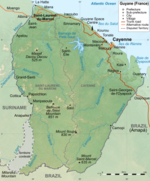
Map claiming disputed territory is undisputably French[edit]
This map will not do. The border dispute is objectively there, and Wikipedia will not take either party's position.
Look at the maps of Borders of Suriname or Guyana. This is how we present this article as well.
Not ALL maps need to focus on border disputes, but there need to be a prominent map where it is made clear Wikipedia is not claiming that, say, the land between the Litani and the Marouini is undisputably French territory.
CapnZapp (talk) 15:42, 7 December 2023 (UTC)
- I should add that I have edited the French (and German) Wikipedias as well. Since I don't know the language I will have to ask someone else to persuade those communities of the inappropriateness of the now removed map. CapnZapp (talk) 15:48, 7 December 2023 (UTC)
- Most maps on Wikipedia show the effective situation, as is common on many maps elsewhere. The dispute should be covered, but the existence of a dispute does not mean we show Belize with a a map of half of it, or have our map of South Korea have to point out the entire territory remains disputed. CMD (talk) 16:00, 7 December 2023 (UTC)
- I agree with you, i am advocating neutrality here for a while now, and in my opinion it is being applied selectively. Do you know how hard it was to get a few maps of Suriname corrected here which at least acknowledges the disputed areas.
- As a neutral platform, Wikipedia should reflect this neutrality across all its content, including the articles featuring maps of Guyana and French Guiana. These disputed territories should be clearly marked not only on Suriname’s maps but also on those of Guyana and French Guiana, given that these disputed involve multiple states and are not one-sided. Absence of these disputed areas on Suriname’s maps and their lack of demarcation on the maps of Guyana and French Guiana can mislead Wikipedia’s readers.
- i have here a list with Neutral maps, i am busy with consensus on the Dutch Wiki at the moment, a few minor changes are expected shortly. If consensus is reached, i would like someone else to change the maps, because some editors are guaranteed to revert it if i will edit it.
- This is a list of Neutral maps of French Guiana that include the disputed area. its a work in progress updated here
Description Neutral map Not neutral Map French Guiana Basic Map Including Disputed area With Suriname


Guyane map (French Guiana) including Disputed Area

French Guiana Locator Map 
Arrondissement Saint-Laurent-du-Maroni 

Arrondissement Saint-Georges 

Arrondissement Cayenne 

Locator map of Arrondissements of French Guiana


French Guiana Arrondissement and Communes Map

Map of the communes of French Guiana


N2 French Guiana map Replaced with Neutral map that shows Both N1 and N2


Route nationale 1 French Guiana map N2 French Guiana map Replaced with Neutral map that shows Both N1 and N2

Map showing the Main Roads near Cayenne, Capital of French Guiana N1, N2, N3, N4

Flag map of French Guiana (France) Pending 
French Guiana Arrondissements and Communes


Locator map of Awala-Yalimapo 

Locator map of Mana 

Locator map of Saint-Laurent-du-Maroni 

Locator map of Apatou 

Locator map of Grand-Santi 

Locator map of Papaichton 

Locator map of Saül 

Locator map of Maripasoula 

Locator map of Camopi 

Locator map of Saint-Georges 

Locator map of Ouanary 

Locator map of Régina 

Locator map of Roura 

Locator map of Saint-Élie 

Locator map of Iracoubo 

Locator map of Sinnamary 

Locator map of Kourou 

Locator map of Macouria 

Locator map of Montsinéry-Tonnegrande 

Locator map of Matoury 

Locator map of Cayenne 

Locator map of Remire-Montjoly 
Map of Kalina population, South America,
Pending 
Guyane department location map Pending 
Guyane department relief location map 


_including_Disputed_Area.png)


.svg)


- SurinameCentral (talk) 01:25, 4 January 2024 (UTC)
- None of these maps make it clear who claims vs who controls, despite the compromise I reached with you at Talk:Guyana–Venezuela territorial dispute#Request Neutral maps to be used (Guyana-Suriname border). Better to leave them alone instead. JM (talk) 20:26, 5 January 2024 (UTC)
- This is neutrality, what is shown on BBC. anything else is just partial bias. The borders were never settled between the TWO NATIONS, so tell me how this is acceptable here, while neutrality is preached? you gave your opinion about it, and i don't agree with it. what you write is for me not neutral. SurinameCentral (talk) 21:12, 5 January 2024 (UTC)
- First of all, you DID agree to compromise at the time. Second of all, this has already been gone over at Wikipedia:Neutral point of view/Noticeboard#South American river maps. Third of all, if you think I'm biased, then take it to Wikipedia:Neutral point of view/Noticeboard, and you'll have outside opinions. JM (talk) 21:21, 5 January 2024 (UTC)
- and look how that turned out, all of the edits were reverted. The incorrect and misleading maps still stand. Go see who reverted them and then continue to see what happened to those river maps that I made neutral versions of. The maps that I had previously places there were of the full borders of Suriname, of course that is completely unacceptable for Wikipedia, but when I added the neutral maps those were reverted too by a user 😂
- I honestly have no hope Wikipedia will ever be truly neutral regarding this matter. Full map of Suriname bad, all must be neutral. Full claimed map of Guyana and French Guiana, perfectly fine. Leave like this don’t touch. SurinameCentral (talk) 21:57, 5 January 2024 (UTC)
- So you're saying you won't take it to the NPOV noticeboard because you believe that you won't get an outcome in your favour? That should be a sign to you that you could be POV-pushing and should reconsider your actions. JM (talk) 22:02, 5 January 2024 (UTC)
- why are you twisting my comment around. i never wrote i am not going to post it there, i will when i have more time to do so.
- it will require some time to formulate it and write it there.
- - Stating the facts here is seen as POV Pushing. if you can give your opinions on what you consider neutral, i can give mine too. SurinameCentral (talk) 22:19, 5 January 2024 (UTC)
- So you're saying you won't take it to the NPOV noticeboard because you believe that you won't get an outcome in your favour? That should be a sign to you that you could be POV-pushing and should reconsider your actions. JM (talk) 22:02, 5 January 2024 (UTC)
- First of all, you DID agree to compromise at the time. Second of all, this has already been gone over at Wikipedia:Neutral point of view/Noticeboard#South American river maps. Third of all, if you think I'm biased, then take it to Wikipedia:Neutral point of view/Noticeboard, and you'll have outside opinions. JM (talk) 21:21, 5 January 2024 (UTC)
- This is neutrality, what is shown on BBC. anything else is just partial bias. The borders were never settled between the TWO NATIONS, so tell me how this is acceptable here, while neutrality is preached? you gave your opinion about it, and i don't agree with it. what you write is for me not neutral. SurinameCentral (talk) 21:12, 5 January 2024 (UTC)
- None of these maps make it clear who claims vs who controls, despite the compromise I reached with you at Talk:Guyana–Venezuela territorial dispute#Request Neutral maps to be used (Guyana-Suriname border). Better to leave them alone instead. JM (talk) 20:26, 5 January 2024 (UTC)
- Please note: The user SurinameCentral was banned for disruptive editing on January 6, 2023 in relation to POV maps. This may be taken into consideration when reviewing the above discussion. It is important to keep the international borders image as is, while using a secondary image to display the disputed areas if need be. The proposed images by SurinameCentral gives the viewer no idea where the disputed land resides. MacDonald2024 (talk) 16:40, 7 January 2024 (UTC)
- C-Class vital articles
- Wikipedia level-4 vital articles
- Wikipedia vital articles in Geography
- C-Class level-4 vital articles
- Wikipedia level-4 vital articles in Geography
- C-Class vital articles in Geography
- C-Class Overseas France articles
- Top-importance Overseas France articles
- All WikiProject Overseas France pages
- C-Class South America articles
- Top-importance South America articles
- C-Class French Guiana articles
- Top-importance French Guiana articles
- French Guiana articles
- WikiProject South America articles
- C-Class France articles
- High-importance France articles
- All WikiProject France pages