Uqturpan County
This article needs additional citations for verification. (December 2009) |
Wushi (Uqturpan) County
乌什县 • ئۇچتۇرپان ناھىيىسى | |
|---|---|
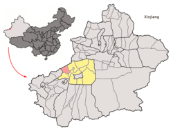
 Location of the county | |
| Country | China |
| Province | Xinjiang |
| Prefecture-level divisions | Aksu Prefecture |
| Time zone | UTC+8 (China Standard) |
Uqturpan (Wushi) County or Uchturpan County (Chinese: 乌什县; Uyghur: ئۇچتۇرپان ناھىيىسى, Учтурпан Наһиүиси, romanized: Uchturpan Nahiyisi, lit. 'Uqturpan Nah̡iyisi') is a county in the Xinjiang Uyghur Autonomous Region under the administration of Aksu Prefecture. It has an area of 9,012 square kilometres (3,480 sq mi) and as of the 2002 census[update] a population of 180,000.
History
Uchturpan is best known for the anti-Qing uprising of the local Turkic (later "Uyghur") people in 1765. Legend says that a local rebel leader was married to Iparhan, known as the "Fragrant Concubine" a descendant of Apaq Khoja. During the turmoil, many fled, and the thousands who remained were killed by Sino-Manchu forces. Later, the area was repopulated by migrants from what is now Southern Xinjiang.[1]
References
- ^ Laura J. Newby, "'Us and Them' in Eighteenth and Nineteenth Century Xinjiang," in Ildikó Bellér-Hann, et al., eds., Situating the Uyghurs between China and Central Asia (2007), p. 26.
41°12′50″N 79°13′23″E / 41.21389°N 79.22306°E
