Watton, East Riding of Yorkshire
| Watton | |
|---|---|
Location within the East Riding of Yorkshire | |
| Population | 259 (2011 census)[1] |
| OS grid reference | TA016501 |
| Civil parish |
|
| Unitary authority | |
| Ceremonial county | |
| Region | |
| Country | England |
| Sovereign state | United Kingdom |
| Post town | DRIFFIELD |
| Postcode district | YO25 |
| Dialling code | 01377 |
| Police | Humberside |
| Fire | Humberside |
| Ambulance | Yorkshire |
| UK Parliament | |
Watton is a village and civil parish in the East Riding of Yorkshire, England. The village is situated on the A164 road, about 6 miles (9.7 km) north of Beverley and 6 miles (9.7 km) south of Driffield.
According to the 2011 UK census the civil parish of Watton had a population of 259,[1] an increase on the 2001 UK census figure of 238.[2]
History
In the 6th century Watton was home to a Frankish saint, Monegunda[3] of Watton[4] and in the 13th century to William de Malton, master-mason who built Beverley Minster[5] was buried here. The Venerable Bede in his Ecclesiastical History of the English People tells of a miracle of Saint John of Beverley that took place in Watton. It is also the setting for the 12th-century miracle story De Sanctimoniali de Wattun.

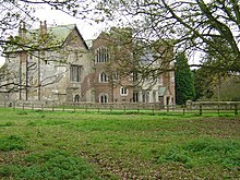
Watton is the location for Watton Priory which was a Gilbertine double monastery founded in 1150 by Eustace fitz John.[6] The present building dates mainly from the 14th and 15th centuries, although it has earlier origins, and a house was added in the 19th century. It is a Grade I listed building.[7][8] The priory was dissolved in 1539 by Henry VIII. The Nun of Watton, famous from Ailred of Rievaulx's De Sanctimoniali de Wattun, is noted for her pregnancy while in the priory.
Near to the priory is the Church of St Mary which was designated a Grade I listed building in September 1966 and is now recorded in the National Heritage List for England, maintained by Historic England.[9] The church building is primarily of 15th century construction but some 13th century materials remain,[10] while the south porch, and north vestry are dated 1859. The parapet to tower is 20th century.
Etymology
The origin of the word Watton is uncertain, but suggestions include:[11][12]
- Old English wád, or woad, and ton meaning small farming settlement; or
- waden meaning ford; or from waétan meaning watery.
References
- ^ a b UK Census (2011). "Local Area Report – Watton Parish (1170211283)". Nomis. Office for National Statistics. Retrieved 27 February 2018.
- ^ UK Census (2001). "Local Area Report – Watton Parish (00FB154)". Nomis. Office for National Statistics. Retrieved 26 February 2020.
- ^ Monegunda is a female name meaning "overprotective" and was known from medieval France.
- ^ Farmer, David (2011). The Oxford Dictionary of Saints. Oxford University Press.
- ^ Malton, William de. A Dictionary of Architecture and Landscape Architecture. Oxford University Press.
- ^ "Forbidden love in Watton". Where I Live - Humber. BBC. 9 January 2006. Retrieved 27 August 2010.
- ^ Historic England. "Watton Abbey (1161550)". National Heritage List for England. Retrieved 2 August 2013.
- ^ Historic England. "Watton Abbey (1161550)". National Heritage List for England. Retrieved 2 May 2013.
- ^ Historic England. "Church of St Mary (1083772)". National Heritage List for England. Retrieved 2 August 2013.
- ^ "Church of St Mary, Watton". British Listed Buildings. Retrieved 13 March 2014.
- ^ "Watton :: Survey of English Place-Names". epns.nottingham.ac.uk. Retrieved 12 October 2021.
- ^ Ekwall, Eilert (1960). The concise Oxford dictionary of English place-names (4 ed.). Oxford: Oxford University Press. p. 501. ISBN 0-19-869103-3.
- Gazetteer — A–Z of Towns Villages and Hamlets. East Riding of Yorkshire Council. 2006. p. 11.
External links
- Watton in the Domesday Book

