Willamina, Oregon: Difference between revisions
ClueBot NG (talk | contribs) m Reverting possible vandalism by 69.168.117.193 to version by YFdyh-bot. False positive? Report it. Thanks, ClueBot NG. (1406236) (Bot) |
|||
| Line 97: | Line 97: | ||
==References== |
==References== |
||
{{reflist}} |
{{reflist}} |
||
Mark soderberg lives here |
|||
Tyson Day lives here too |
|||
==External links== |
==External links== |
||
Revision as of 17:29, 17 December 2012
Willamina, Oregon | |
|---|---|
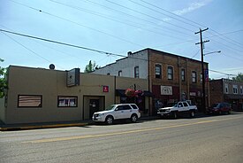
 Main Street in downtown | |
 Location in Oregon | |
| Country | United States |
| State | Oregon |
| Counties | Yamhill, Polk |
| Incorporated | 1903 |
| Government | |
| • Mayor | Vernon Mosser |
| Area | |
| • Total | 0.9 sq mi (2.3 km2) |
| • Land | 0.9 sq mi (2.3 km2) |
| • Water | 0.1 sq mi (0.04 km2) |
| Elevation | 225 ft (68.6 m) |
| Population (2000) | |
| • Total | 1,844 |
| • Density | 2,138.0/sq mi (827.9/km2) |
| Time zone | UTC-8 (Pacific) |
| • Summer (DST) | UTC-7 (Pacific) |
| ZIP code | 97396 |
| Area code | 503 |
| FIPS code | 41-82350Template:GR |
| GNIS feature ID | 1163355Template:GR |
| Website | www.ci.willamina.or.us |
Willamina is a city in Polk and Yamhill Counties in the U.S. state of Oregon. The population was 1,844 at the 2000 census, with an unofficial estimated population of 1,885 in 2006.[1]
The Yamhill County portion of Willamina is part of the Portland–Vancouver–Beaverton, OR-WA Metropolitan Statistical Area, while the Polk County portion is part of the Salem, OR Metropolitan Statistical Area.
History
The history of the city of Willamina dates back to 1846 when a settler named Willamina Williams fell off her horse and into a creek which was subsequently named after her.[2]
Geography
According to the United States Census Bureau, the city has a total area of 0.9 square miles (2.3 km²), of which, 0.9 square miles (2.2 km²) of it is land and 0.04 square miles (0.1 km²) of it (2.25%) is water.
The city lies near the intersection of Oregon Route 18, Oregon Route 18 Business, and Oregon Route 22 next to the South Yamhill River. The communities of Shipley and Sheridan are to the east, and Valley Junction is to the west.
Demographics
As of the censusTemplate:GR of 2000, there were 1,844 people, 666 households, and 480 families residing in the city. The population density was 2,138.0 people per square mile (827.9/km²). There were 715 housing units at an average density of 829.0 per square mile (321.0/km²). The racial makeup of the city was 84.22% White, 0.16% African American, 9.82% Native American, 0.16% Asian, 0.05% Pacific Islander, 1.84% from other races, and 3.74% from two or more races. Hispanic or Latino of any race were 3.42% of the population.
There were 666 households out of which 39.0% had children under the age of 18 living with them, 52.1% were married couples living together, 13.4% had a female householder with no husband present, and 27.9% were non-families. 22.7% of all households were made up of individuals and 7.4% had someone living alone who was 65 years of age or older. The average household size was 2.77 and the average family size was 3.19.
In the city the population was spread out with 32.4% under the age of 18, 9.1% from 18 to 24, 28.3% from 25 to 44, 19.8% from 45 to 64, and 10.4% who were 65 years of age or older. The median age was 32 years. For every 100 females there were 99.6 males. For every 100 females age 18 and over, there were 90.8 males.
The median income for a household in the city was $32,326, and the median income for a family was $37,250. Males had a median income of $30,082 versus $22,432 for females. The per capita income for the city was $13,349. About 10.9% of families and 14.3% of the population were below the poverty line, including 17.2% of those under age 18 and 7.7% of those age 65 or over.
Climate

The overall climate of Willamina can be considered Mediterranean. This is characteristic of areas with wet and mild winters and warm and dry summers.
Willamina receives an average of 51.45" of precipitation per year based on the Western Regional Climate Center averages from 1971–2000. Willamina's highest annual precipitation was 84.33" in 1996 and the lowest was 32.28" in 1944. Willamina's wettest month was December 1996 with 22.00". Willamina has had 20 months since 1935 in which no precipitation has fallen, the most recent being August 2005.
On average Willamina receives 10.5" of snowfall annually. The highest seasonal snowfall was 73.6" in the winter of 1949-1950 and the lowest has been none on many occasions. Willamina's snowiest month was January 1950 with 68.6".
Temperature data is not collected at the Willamina weather station.
References
- ^ PSU:Population Research Center
- ^ "City of Willamina, OR". Retrieved 12/04/2012.
{{cite web}}: Check date values in:|accessdate=(help)
Mark soderberg lives here Tyson Day lives here too
External links
![]() Media related to Willamina, Oregon at Wikimedia Commons
Media related to Willamina, Oregon at Wikimedia Commons


