
Bath, Maine: Difference between revisions
No edit summary |
|||
| Line 151: | Line 151: | ||
* [http://www.smccme.edu/docs.php?section=1&navid=137&levelfour=138&docid=131 Southern Maine Community College at Bath] |
* [http://www.smccme.edu/docs.php?section=1&navid=137&levelfour=138&docid=131 Southern Maine Community College at Bath] |
||
* [http://www.learn.maine.edu/bath/ University College at Bath/Brunswick] |
* [http://www.learn.maine.edu/bath/ University College at Bath/Brunswick] |
||
==Climate== |
|||
{{Weather box |
|||
|location = Bath, ME |
|||
|single line = Yes |
|||
|Jan record high F = 61 |
|||
|Feb record high F = 59 |
|||
|Mar record high F = 73 |
|||
|Apr record high F = 84 |
|||
|May record high F = 94 |
|||
|Jun record high F = 100 |
|||
|Jul record high F = 98 |
|||
|Aug record high F = 104 |
|||
|Sep record high F = 95 |
|||
|Oct record high F = 85 |
|||
|Nov record high F = 74 |
|||
|Dec record high F = 68 |
|||
|year record high F = 104 |
|||
|Jan high F = 31 |
|||
|Feb high F = 34 |
|||
|Mar high F = 43 |
|||
|Apr high F = 54 |
|||
|May high F = 65 |
|||
|Jun high F = 74 |
|||
|Jul high F = 80 |
|||
|Aug high F = 79 |
|||
|Sep high F = 70 |
|||
|Oct high F = 59 |
|||
|Nov high F = 48 |
|||
|Dec high F = 37 |
|||
|year high F = 56 |
|||
|Jan low F = 10 |
|||
|Feb low F = 14 |
|||
|Mar low F = 23 |
|||
|Apr low F = 33 |
|||
|May low F = 43 |
|||
|Jun low F = 52 |
|||
|Jul low F = 58 |
|||
|Aug low F = 57 |
|||
|Sep low F = 48 |
|||
|Oct low F = 37 |
|||
|Nov low F = 29 |
|||
|Dec low F = 17 |
|||
|year low F = 35 |
|||
|Jan record low F = -49 |
|||
|Feb record low F = -25 |
|||
|Mar record low F = -10 |
|||
|Apr record low F = 13 |
|||
|May record low F = 27 |
|||
|Jun record low F = 34 |
|||
|Jul record low F = 37 |
|||
|Aug record low F = 37 |
|||
|Sep record low F = 28 |
|||
|Oct record low F = 18 |
|||
|Nov record low F = 1 |
|||
|Dec record low F = -21 |
|||
|year record low F = -49 |
|||
|Jan precipitation inch = 4.06 |
|||
|Feb precipitation inch = 3.57 |
|||
|Mar precipitation inch = 4.55 |
|||
|Apr precipitation inch = 4.47 |
|||
|May precipitation inch = 4.11 |
|||
|Jun precipitation inch = 3.57 |
|||
|Jul precipitation inch = 3.31 |
|||
|Aug precipitation inch = 3.15 |
|||
|Sep precipitation inch = 3.71 |
|||
|Oct precipitation inch = 4.19 |
|||
|Nov precipitation inch = 4.87 |
|||
|Dec precipitation inch = 4.47 |
|||
|year precipitation inch = 48.03 |
|||
|source 1 = <ref>{{cite web |
|||
|url=http://www.weather.com/outlook/health/fitness/wxclimatology/monthly/graph/USME0021 |title=Average Weather for Bath, ME - Temperature and Precipitation |publisher=Weather.com |accessdate=August 27, 2010}}</ref> |
|||
|date=August 2010 |
|||
}} |
|||
==Sites of interest== |
==Sites of interest== |
||
Revision as of 01:54, 31 August 2010
Bath, Maine | |
|---|---|
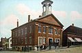
 Bath City Hall | |
 Seal | |
| Nickname: City of Ships | |
 Location of Bath in Maine | |
| Country | United States |
| State | Maine |
| County | Sagadahoc |
| Incorporated (town) | February 17, 1781 |
| Incorporated (city) | June 14, 1847 |
| Area | |
| • Total | 13.2 sq mi (34.3 km2) |
| • Land | 9.1 sq mi (23.6 km2) |
| • Water | 4.1 sq mi (10.7 km2) |
| Elevation | 62 ft (19 m) |
| Population (2000) | |
| • Total | 9,266 |
| • Density | 1,016.8/sq mi (392.6/km2) |
| Time zone | UTC-5 (Eastern (EST)) |
| • Summer (DST) | UTC-4 (EDT) |
| ZIP code | 04530 |
| Area code | 207 |
| FIPS code | 23-03355 |
| GNIS feature ID | 0561723 |
Bath is a city in Sagadahoc County, Maine, in the United States. As of the 2000 census, the city population was 9,266. It is the county seat of Sagadahoc CountyTemplate:GR. Located on the Kennebec River, Bath is a port of entry with a good harbor. The city is popular with tourists, many drawn by its 19th-century architecture. It is home to the Bath Iron Works and Heritage Days Festival, held annually on the Fourth of July weekend.
Bath is part of the Portland–South Portland–Biddeford, Maine Metropolitan Statistical Area.
History

Abenaki Indians called the area Sagadahoc, meaning "mouth of big river." It was a reference to the Kennebec River, which Samuel de Champlain explored in 1605. Popham Colony was established in 1607 downstream, together with Fort St. George. The settlement failed due to harsh weather and lack of leadership, but the colonists built the New World's first oceangoing vessel constructed by English shipwrights, the Virginia of Sagadahoc. It provided passage back to England.[citation needed]
The next settlement at Sagadahoc was about 1660, when land titles were purchased from an Indian sagamore known as Robinhood.[1] Incorporated as part of Georgetown in 1753, Bath was set off and incorporated as a town on February 17, 1781. It was named by the postmaster, Dummer Sewell, after Bath in Somerset, England. In 1844, a portion of the town was set off to create West Bath. On June 14, 1847, Bath was incorporated as a city, and in 1854 designated county seat. Land was annexed from West Bath in 1855.[citation needed]
Several industries developed in the city, including lumber, iron and brass, with trade in ice and coal. But Bath is renowned for shipbuilding, which began here in 1743 when Jonathan Philbrook and his sons built 2 vessels. Since then, roughly 5,000 vessels have been launched in the area, which at one time had more than 200 shipbuilding firms. Bath became the nation's fifth largest seaport by the mid-1800s, producing clipper ships that sailed to ports around the world. The last commercial enterprise to build wooden ships in the city was the Percy & Small Shipyard, which was acquired for preservation in 1971 by the Maine Maritime Museum. But the most famous shipyard is the Bath Iron Works, founded in 1884 by Thomas W. Hyde. It has built hundreds of wooden and steel vessels, mostly warships for the U.S. Navy.[1] During World War II, Bath Iron Works launched a new ship every 17 days. The shipyard is a major regional employer, and operates today as a division of the General Dynamics Corporation.[citation needed]
The city is noted for its Federal, Greek Revival, and Italianate architecture, including the 1858 Custom House and Post Office designed by Ammi B. Young. Bath is sister city to Shariki (now Tsugaru) in Japan, where the locally-built full rigged ship Cheseborough was wrecked in 1889. Scenes from the movies Message in a Bottle (1999) and The Man Without a Face (1993) were filmed in the city.
-
 Custom House in c. 1905
 -
 Library Park in 1917
 -
 Old City Hall in 1909
 -
 Front Street in c. 1920


Geography
Bath is located at 43°54′59″N 69°49′21″W / 43.91639°N 69.82250°W (43.916293, -69.822565)Template:GR.
According to the United States Census Bureau, the city has a total area of 13.2 square miles (34.3 km²), of which, 9.1 square miles (23.6 km²) of it is land and 4.1 square miles (10.7 km²) of it (31.12%) is water. Situated at the head of Casco Bay, Bath is drained by the Kennebec River.
Demographics
| Census | Pop. | Note | %± |
|---|---|---|---|
| 1860 | 8,076 | — | |
| 1870 | 7,371 | −8.7% | |
| 1880 | 7,874 | 6.8% | |
| 1890 | 8,723 | 10.8% | |
| 1900 | 10,477 | 20.1% | |
| 1910 | 9,396 | −10.3% | |
| 1920 | 14,731 | 56.8% | |
| 1930 | 9,110 | −38.2% | |
| 1940 | 10,235 | 12.3% | |
| 1950 | 10,644 | 4.0% | |
| 1960 | 10,717 | 0.7% | |
| 1970 | 9,679 | −9.7% | |
| 1980 | 10,246 | 5.9% | |
| 1990 | 9,799 | −4.4% | |
| 2000 | 9,266 | −5.4% | |
| sources:[2] | |||
As of the censusTemplate:GR of 2000, there were 9,266 people, 4,042 households, and 2,344 families residing in the city. The population density was 1,016.8 people per square mile (392.7/km²). There were 4,383 housing units at an average density of 481.0/sq mi (185.8/km²). The racial makeup of the city was 94.92% White, 1.60% Black or African American, 0.58% Native American, 0.47% Asian, 0.13% Pacific Islander, 0.68% from other races, and 1.62% from two or more races. Hispanic or Latino of any race were 1.76% of the population.
There were 4,042 households out of which 29.7% had children under the age of 18 living with them, 40.8% were married couples living together, 13.1% had a female householder with no husband present, and 42.0% were non-families. 34.1% of all households were made up of individuals and 13.0% had someone living alone who was 65 years of age or older. The average household size was 2.26 and the average family size was 2.91.
In the city the population was spread out with 25.0% under the age of 18, 8.4% from 18 to 24, 29.5% from 25 to 44, 23.0% from 45 to 64, and 14.1% who were 65 years of age or older. The median age was 37 years. For every 100 females there were 91.4 males. For every 100 females age 18 and over, there were 86.9 males.
The median household income in the city was $36,372, and the median family income was $45,830. Males had a median income of $35,064 versus $22,439 for females. The per capita income for the city was $19,112. About 9.3% of families and 11.8% of the population were below the poverty line, including 17.5% of those under age 18 and 9.6% of those age 65 or over.
Education

- Bath School Department
- Dike-Newell Elementary, grades K-3
- Fisher-Mitchell Elementary, grades 3-5
- Bath Middle School — serves 430 students in grades 6-8 as of 2006. The school's mascot is the Destroyers, a type of ship built by the Bath Iron Works. The school colors are blue and white.
- Morse High School — The Morse High Shipbuilders (team). Sports include Cross Country, Football, Cheerleading, Swimming, Basketball, Tennis, Indoor/Outdoor Track & Field, Softball, Baseball. Clubs include the International Club, O Ambassadors Club, Anime Club, and more.
- Hyde School, a private boarding school
- Southern Maine Community College at Bath
- University College at Bath/Brunswick
Climate
| Climate data for Bath, ME | |||||||||||||
|---|---|---|---|---|---|---|---|---|---|---|---|---|---|
| Month | Jan | Feb | Mar | Apr | May | Jun | Jul | Aug | Sep | Oct | Nov | Dec | Year |
| Record high °F (°C) | 61 (16) |
59 (15) |
73 (23) |
84 (29) |
94 (34) |
100 (38) |
98 (37) |
104 (40) |
95 (35) |
85 (29) |
74 (23) |
68 (20) |
104 (40) |
| Mean daily maximum °F (°C) | 31 (−1) |
34 (1) |
43 (6) |
54 (12) |
65 (18) |
74 (23) |
80 (27) |
79 (26) |
70 (21) |
59 (15) |
48 (9) |
37 (3) |
56 (13) |
| Mean daily minimum °F (°C) | 10 (−12) |
14 (−10) |
23 (−5) |
33 (1) |
43 (6) |
52 (11) |
58 (14) |
57 (14) |
48 (9) |
37 (3) |
29 (−2) |
17 (−8) |
35 (2) |
| Record low °F (°C) | −49 (−45) |
−25 (−32) |
−10 (−23) |
13 (−11) |
27 (−3) |
34 (1) |
37 (3) |
37 (3) |
28 (−2) |
18 (−8) |
1 (−17) |
−21 (−29) |
−49 (−45) |
| Average precipitation inches (mm) | 4.06 (103) |
3.57 (91) |
4.55 (116) |
4.47 (114) |
4.11 (104) |
3.57 (91) |
3.31 (84) |
3.15 (80) |
3.71 (94) |
4.19 (106) |
4.87 (124) |
4.47 (114) |
48.03 (1,220) |
| Source: [3] | |||||||||||||
Sites of interest

Notable people


- Connie Chung, journalist.[citation needed]
- Edward Davis, buccaneer/engineer.[citation needed]
- Samuel Davis, congressman.
- Claude Demetrius, songwriter.
- Emma Eames, singer.
- Henry Gannett, geographer.
- Charles Frederick Hughes, admiral.
- William King, governor.
- George F. Magoun, first president of Iowa College, now Grinnell College.
- Freeman H. Morse, congressman & mayor.
- Amos Nourse, physician & senator.
- Maury Povich, TV Personality.[citation needed]
- Harold M. Sewall, ambassador.
- Sumner Sewall, governor.
- Silas Soule, abolitionist & soldier.
- Francis B. Stockbridge, senator.
- Peleg Tallman, congressman.
- William Zorach, sculptor.
References
Notes
Further reading
- History of Bath and Environs, Sagadahoc County, Maine, 1607-1894. By Parker McCobb Reed. Published 1894. Full image at books.google.
- History of Bath, Maine
- Historical Sketch of Bath, Maine
- History of Destroyers at Bath Iron Works
External links
- Maine Eastern Railroad
- City of Bath, Maine
- Patten Free Library
- Bath Historical Society
- Sagadahoc Preservation, Inc.
- Main Street Bath
- DeLorme Map of Bath, Maine
- Aerial photo
- Maine's First Ship -- Reconstructing the Virginia
- Maine Maritime Museum
Municipalities and communities of Sagadahoc County, Maine, United States | ||
|---|---|---|
| City | 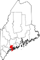 | |
| Towns | ||
| Unorganized territory | ||
| CDPs | ||
| Other villages | ||